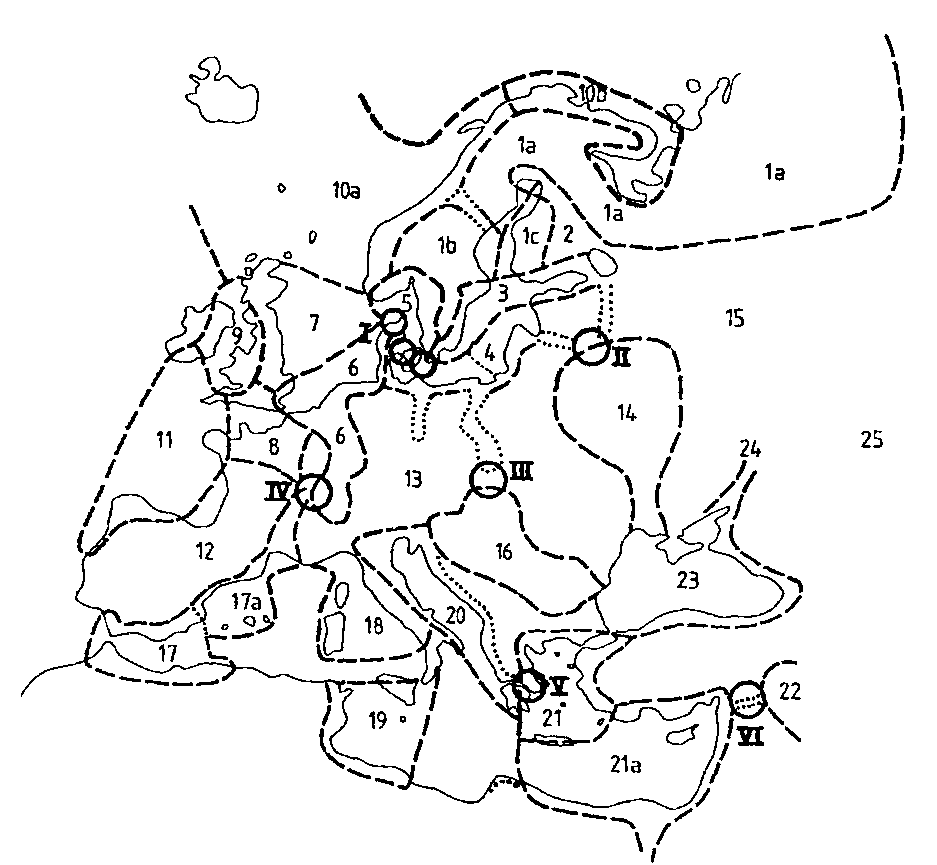
The archaeological concept combining sea and land would be the maritime cultural landscape. It means that the starting point for the subject of maritime archaeology is maritime culture. The maritimity of people is conditional, i.e. a cultural factor. If you do not possess a population attuned to maritime preoccupations, even if a current population is residing at the sea shore, there is no maritime culture. On the other hand maritime (the transport aspect) culture follows the boat and its crew, even inland. Basically the dependence and the exploitation of the waters could be as fundamental in lakes and waterways as on the sea itself (on the Swedish lake Vänern see Westerdahl in print & in prep.). I am not going to give any details here of the elements and categories of remains constituting this landscape, nor of its many aspects. That has been and will be done elsewhere (cf Westerdahl 1986, 1987-89, 1991b and in pr.). But I want to point out that both are meant to unite sea and land, archaeology and its little brother at the shore. The reason for their present separation is partly the apparent narrowness of the diving mask. It is not the question of underwater contra land archaeology. To the present author, the main concern would be to broaden the perspective of maritime archaeology in instruction as well as in research to all aspects of the maritime cultural landscape. Two concepts will be taken up. One is directly related to ships and ship construction: traditional zones of transport geography; transport zones for short. This concept expresses at least one aspect of the maritime cultural landscape, the landscape of transportation or, if you like, of communication. The theory of transport zones should be dissolved into these two component parts, which can be considered separately:
However, these rules are not indeed intended as natural laws: similar natural prerequisites do not necessarily lead to the same result/ adaptation, in this case the same boat type. There are many aspects of function and of identity, of the same significance as embodied by the linguistic term "neighbour opposition." Cultural and thereby also ethnic factors may be of direct importance, although it may sometimes be hard to distinguish which aspect is the dominant if the boat traditions coincide with distinct human ecosystems. Some possible questions arisen out of my own inconstancy are: "Saamish" boats or inland adaptation? (Westerdahl 1988). Perhaps the stakes would be even less clear concerning the "West-Slavonic" boats, but are they possibly "just" regional adaptations along the southern shores of the Baltic? (Westerdahl 1985a, b). At the transition to another zone there are often found natural obstacles of different kinds (the river mouth banks, other sediments in sea routes, mountain ranges, rapids or cataracts, with portages, hauling or carrying sites, dangerous points, promontories and shallows/ banks. They mean the reloading of cargo and the change of means of transport at a well-defined site (transit/ion point, transit/ion/ pivot ), for an accompanying water or land transport in the new zone. Some of these transit points are sometimes temporary, especially in an area of mobile quaternary deposits. In the Scandinavian area there are two dangerous points par préference, The Skaw/ Skagen on Jutland and Falsterbo Reef in Scania. The Skaw is the dividing line between the North Sea and the Kattegat. If the Limfiord passage through Jutland was closed, which happened several times during ancient times the Reef was an almost unsurmountable barrier to shipping (at least from around 1150). The northernmost tip of Jutland appeared at times as a sandy archipelago. From the outside (W.) of the Reef an earlier outlet for passages to and fro Norway, called the Sløj channel, closed around 1100. It was infinitely safer in passages fro the North Sea to the Baltic to go overland at the root of Jutland (cf the early prominence of Ribe, Hamburg and other Atlantic sites) or in exceptional cases to sail directly to South Norway and to hug the present Swedish west coast southward. Skippers valiantly doubling the Reef, ummelandsfarer, presumably in cogs, are known from historical sources around 1255, but seem to have existed for some time then. At Falsterbo/Skanör emerged the most important maritime market sites of Northern Europe, presumably because of this position. Ships from the Sound and from the North Sea anchored to the north, ships from the Baltic to the south. Thus, both kinds avoided doubling the Reef. Traffic over the isthmus closed the deals, but even some waterways were open, one of them dug as a canal for small barges (indicated also by its place name, Ammerännan ). Herring caught in enormous quantities up to the late 16th century by tens of thousands of fishermen of fairly long-range origins supplied the everyday mass product. The market revenue supplied one-third of the income of the Danish king, who may once have initiated both fishing and trade and who strictly controlled the proceedings. Already in a Nordic itinerary to the Holy Land from the end of the 11th century the first point mentioned after Ribe is zincfal in flandriam. At the nearby entrepot which we know as Bruges met already both overland traffic from Central Europe (e.g. the Champagne fairs) and shipping from the North, ultimately also shipping from the Mediterranean (in 1297). When the two latter both passed Bruges regularly directly to destinations in the Mediterranean and to the North Bruges lost its role (beginnings of the 14th century: according to Braudel 1985 "the victory of the sea over the land", i. e. the "Isthmus of France"). The final and irreversible sanding in of the river Zwin came later and was just the seal of the doom. These three examples clearly show the diversified character of the transit points. The concept covers a whole hierarchy of related sites, large and small, important and fairly insignificant ones of (perhaps) merely local interest. Fundamentally, the zones consist of seven different types or categories:
Fig 3: Coastal transport zones of Europe. Roughly this order of zone types is possibly of some chronological significance. The extended kind of ferry zones can very plausibly be illustrated by the find sites of the oldest plankbuilt boats of Northern Europe: the British Bronze Age vessels of the Ferriby type: the Humber and Severn/Bristol channel estuaries and the Dover (-Calais) passage. To return to the main period of rock carvings of the North, the astounding conformity of the ship figures, which make up by far the most common figurative pattern, must point to basically the same types of boat. These types also belongs to the Early Iron Age as shown by the find of the Hjortspring boat (c 350 BC) of the island of Als, south Denmark. It couldn't possibly be unique in its kind. A recent find in north central Sweden (at Själevad close to Örnsköldsvik) of an almost identical thwart as in the Hjortspring boat but made of presumably local pine instead of oak as this is north of the oak line could indicate that these boats were used in all Scandinavia (Jansson 1994). The latter site is situated at the northern limit of rock carvings with Bronze Age ship motives. These paddled canoes must be adapted to a scenario of rapid but limited water movement, including attacks, in very calm and sheltered coastal or inland waters. Such warrior craft presumably were copied rapidly by any `peer polity´ in the area of interaction. That area of cultural interaction could also be delimited and subdivided by other cultural elements, such as the coastal cairns and the rock carvings. But there appears to be a fundamental difference between these adaptations and that of the big rowing boats and early sailing ships. In the early Middle Ages can be assumed in each coastal zone or corridors at least different route system: one hugging the coast very closely, one farther out relying on night havens at promontories etc. and one outer route, the utleid of Nordic tradition (Westerdahl 1990a). Each relates to at least one ship-type. Such a pattern is very unlikely during the Bronze Age. The zones that I have sketched may therefore have got their approximate limits in the North with the first iron-clinkered rowing ships of the Nydam type (the find itself dated to 310 AD, but the `type´ is certainly earlier). The Mediterranean zones of corresponding sizes must have been in existence already during the Bronze Age of that area. Another important difference is the simple and obvious one, between the big ships of each period and the smaller ships, relating to small-scale shipping of the same period. The large ships are reasonably more apt to change than the small ones, being influenced more rapidly by international trade and the changes in grand-scale shipbuilding (e. g. Crumlin-Pedersen 1997: 17), and accordingly the old zonal pattern with their ship-types survive only at a smaller-scale level, developing into new variations. They seldom appear as anything but functional survivals. But the division according to ship types would presumably be drawn at the same zonal borders as before. The older traditional transport zones are later superimposed by new dynamic zones concurrently with economic processes, but survive thus more or less in small-scale shipping for a long time. Political influence may induce a change in the main direction of traffic but still within the zone or the corridor. Other changes affect ship building in the relevant zones to a considerable degree. Mixtures of ship building "traditions" appear to be normal. If two zones become one, the amalgamation produces a new ship type adapted to conditions in the extended zone but with traits taken from both preceding zones. A classical instance would be the Gallo-Roman river vessels of the Rhine (Ellmers 1969, Arnold 1975, 1980, 1992 etc., later critique on their "Celtic" character by Höckmann on the lines of de Weerd 1988). An apt subtitle would be bottom-based constructions (after Fred Hocker). These vessels gradually extend their operations into tidal waters along the English Channel (first centuries AD) and the Low Countries (Marsden 1976, 1994). From there comes the obvious but largely archaeologically unknown transition of the Proto-cog on a great scale from the Waddenzee at the North Sea to the south part of the Baltic c AD 1200 (the first finds at N. Jutland). As the end product we seem to get standardized vessels of the Bremen type c 1350-1400 (published by the Deutsches Schiffahrtsmuseum of Bremerhaven), with traits from the North Sea and from the Baltic, but still with some ancestral details revealing their origins on the river shores of the Rhine (Crumlin-Pedersen 1965, cf Ellmers 1985, partly with another interpretation). There are also more local smaller zones with relatively distinct boats, even boat types, at the coast as well as in larger river systems. In the case of my field area, the Norrland coast of Sweden, the borders of these zones run roughly parallel to the coast. The waterfront zone (which historically is a variable entity due to the rapid land uplift), with continuous agrarian settlements from the Middle Iron Age (the centuries around the year 0), but intermittent streaks of cultivation and animal husbandry back to the Neolithic. It displays coastal boats and lower river or estuary vessels of a distinctly common character with other parts of the coastal transport zone (which parts I originally called `maritime cultural areas´). Inland follow the Medieval settlement areas of the coastal zone (50-60 kms as the crow flies, with the lake types and the river boats used between the estuary and the first rapids upstream. The inland zone is the immense forest and mountain continuum of ca. 400 kms across the Scandinavian peninsula, where the inland boats, originally Saamish, display various adaptations to the roadless interior, to the rapids, the portage stretches and to its poor supply of iron. This zone was only settled in an agrarian sense during the last three centuries (on the amphibian transport patterns of this Zavoloshe zone, extending into Finland and Russia see Westerdahl 1996, 1997). I presume that these considerations on transport zones would help in an analysis of the connection between patterns in water and land transport. They will also offer an alternative to the prevalent model of explanation of variation in boat building. This model presupposes that fundamentally repetitive traditions of boat construction is the overall explanation, and that innovations from various centres of diffusion are the most important causes of change. However, I cannot deny totally the value of such partial approaches. Additionally, this concept offers an alternative view of the definition of a ship type. The ship type is accordingly not just another archaeological type or implement. The functions of this floating combination of technological compounds could not be reduced to a simple archaeological type. It should rather be defined in the process of explaining its use, of delimiting the vessel´s function from river to sea, from more or less closed transport zones to the open sea and then on to new zones that are gradually established along the way of change. The ship type concept thus would appear to be fruitfully bound up with the concept of the transport zones. In this interpretation the active, and rational adaptation is put onto the primary level, but cultural, cognitive and in a certain sense "irrational" or for that matter "dynamic" factors are still in the picture. Thus could adaptation be intentional or unintentional or even illusory (not only to the present observer). The differences of river boats may not always appear as independent types, but rather as variations of details . As an example we may take the varieties of the Wisla and in its tributaries (Smolarek 1985, Litwin 1995). The same rules seem to be prevalent in the descriptions of Francois Beaudoin (1985, 1986) on the local boats of the rivers and coasts of France. The identity of the type is perhaps mainly expressed in a particular type name. Of course that may still be referred to as local tradition or identity. To me the differences between West Slavonic and South Scandinavian ships appear, as mentioned above, to be at least essentially of the same order. Thus they belong to coasts of the same basic character but display local although distinct details. Conservatism may certainly play a role in this evaluation, but substantially on a rational basis. Innovations could be diffused, no doubt, but they do not in themselves explain change. Sometimes innovations only work partially, and they are modified according to -well, not tradition then, but rather to the conditions of their usage. For acceptance of an innovation is needed both receptivity at the right moment and suitable socioeconomic conditions. In history ship building has developed by leaps in a way that must have had a total economic as well as cultural shift of paradigm as its foundation (Westerdahl 1992, 1994a, 1995, cf Varenius 1992, Bill 1995: 202). Due to lack of space I will deal with the important political factors in a later contribution. Maritime enclaves / nichesThis concept has more to do with the social origins of shipping and shipbuilding or -if you like- with the social aspect of the maritime cultural landscape.
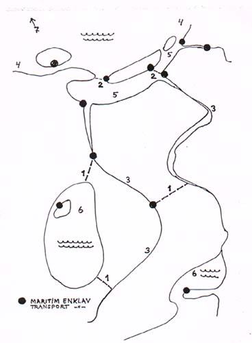
Maritime enclaves. These enclaves/ niches are areas outside of the towns with permanent settlements, where a large majority (up to 80 %) of the inhabitants are engaged in maritime activities and where maritime cultural experience and tradition have been accumulated from generation to generation. Fishing is their primary activity. Their character is clearly indicated by comparisons with other neighbouring areas which display quite another structure. Very probably their full development in shipping presuppose urban contractors, i.e. they come into existence in the North mainly during the High Middle Ages. There are also found transport enclaves of approximately the same character along inland waterways. Before the Trollhätte canal (finished in 1800) 900 horses called edsmärrar with their drivers employed curious hauling gear basically for iron cargoes on Edsvägen, the Isthmus Road, between Lake Vänern and the Göta älv river, illustrated in a drawing by Linnaeus in 1746. Several such long portages in Russia during the Middle Ages are known (e. g. in Kerner 1946). The barge-handling families of central Europe are mobile, but certainly have had the same tendency to gather in larger colonies. Even floating timber (on rafts) would produce concentrations (cf Unterrodach in Frankenwald, Germany, according to Piot/ Schweizer 1985). Such enclaves connected to land roads were particularly common before the railways, in a case with which I am particularly familiar a number of agrarian parishes in N. Västergötland, effecting cargo traffic between Stockholm and Gothenburg (Carlsson 1956: 165).
Boat transport, by Linnaeus in 1746. The significance of these enclaves appears to be limited in time. During later centuries their shipowners and captains often get absorbed by great port cities (on the absorption into Gothenburg of the enclave of the Onsala peninsula of Halland, Sweden: Sandklef 1973). Often the enclave is found in barren lands, with a weak supporting capacity from an agrarian point of view. In a traditional transport zone one or several enclaves more or less monopolize maritime (transport) activities within a zone. This tendency would seem to appear as particularly common in inland waterways. An example is offered by the Swedish lake Vänern (Westerdahl in pr: Inland boats..., in prep). In many cases these niches have been secondarily "created", from a very modest beginning in local experience, along with inland canal works by the intentional intercession and sometimes privileges of authorities/ governments. The role of some river enclaves of France has been retold by Braudel (1989/1986). In coastal zones their role is often replaced by harbour cities, with which they have a certain cultural affinity, although in a `dispersed´ sense. In my original research area (Westerdahl 1987-89) there were found no urban centres. Here I am therefore content to refer to Rudolph (1980) on the culture of the ports and harbour cities. Fishing was one of the fundamental pillars in many coastal towns, too. In this way a maritime experience had been built up on boats also for the navigational art of shipping which certainly reminds you of the occupational hierarchy of maritime enclaves. Christer Westerdahl, 1998 Inst of Archaeology and Ethnology ReferencesArnold, Béat: 1975. The Gallo-Roman Boat from the Bay of Bevaix, Lake Neuchatel, Switzerland. In: IJNA 4.1.: 123-126. Arnold, Beat: 1980: Some remarks on caulking in Celtic boat construction. In: IJNA 6/7 1977 : 293-267. Arnold, Béat: 1992. Batellerie gallo-romaine sur le lac de Neuchatel. Tomes 1-2. Sainte-Blaise. Beaudoin, Francois: 1985. Bateaux des fleuves de France. Douarnenez. Beaudoin, Francois: 1986. Bateaux des cotes de France. Douarnenez. Bill, Jan: 1995. Getting into business. Reflections of a market economy in medieval Scandinavian shipbuilding. I: Olsen, O/ Rieck, F/ Skamby Madsen, J (Eds): 1995. Shipshape. Essays for Ole Crumlin-Pedersen: 195-202. Roskilde. Braudel, Fernand: 1972 (1949). The Mediterranean and the Mediterranean World in the Age of Philip II: La Méditerranée et le monde Méditerranéen à l´époque de Philippe II. Paris 1949. Braudel, Fernand: 1985. La dynamique du capitalisme. Paris. Braudel, Fernand: 1989 (1986). The Identity of France: L´identité de la France, Paris 1986. Brendalsmo, Jan & Røthe Gunnhild: 1992. Haugbrot eller de levendes forhold til de døde -en komparativ analyse. In: Medeltidsarkeologisk Tidskrift (META) 92 1-2: 84-119. Carlsson, Sten: 1956. Bonden i svensk historia III. Stockholm. Carpenter, Stephen: 1991: Fra undervannsarkeologi til maritim arkeologi. Hovedfagsopgave i arkeologi, ISV, University of Tromsø. Unpublished seminar paper. Carpenter, Stephen: 1992. Fra råseil til radar- om bruken av maritime symboler. In: Ottar 5/92: 42-47. Casson, Lionel: 1964. Illustrated History of Ships & Boats. New York. Casson, Lionel: 1971. Ships and Seamanship in the Ancient World. Princeton, N J. Cieslak, E (Ed): 1978. Historia Gdanska Tom I do roku 1454. Gdansk. Crumlin-Pedersen, Ole: 1965. Cog-Kogge- Kaag. Træk af en frisisk skibstypes historie. In: Handels- og Søfartsmuseet på Kronborg. Årbog 1965: 81- 144. Crumlin-Pedersen, Ole: 1997. Viking-Age Ships and Shipbuilding in Hedeby/ Haithabu and Schleswig. Roskilde. Eames, Aled: 1981. Ships and Seamen of Anglesey 1558-1918. National Maritime Museum Modern Maritime Classics Reprint No. 4. Greenwich. Edlund, Lars-Erik (Ed.): 1994. Kulturgränser myt eller verklighet? DIABAS 4. Umeå university. Umeå. Ellmers, Detlev: 1969. Keltischer Schiffbau. In: Jahrbuch des Römisch-ermanischen Zentralmuseums Mainz (RGZM) Band 16. Mainz Ellmers, Detlev: 1972. Frühmittelalterliche Handelsschiffahrt im Mittel- und Nordeuropa. Neumünster. Diss. Ellmers, Detlev: 1985. Frisian and Hanseatic Merchants sailed the Cog. In: Bang- Andersen, B/ Greenhill, B/ Grude, E H (Eds): The North Sea. A Highway of Economic and Cultural Exchange, Character-history. Stavanger, Oslo etc: 79-95. Filipowiak, Wladyslaw: 1994. Shipbuilding at the Mouth of the River Odra (Oder). In: Westerdahl, Christer (Ed): Crossroads in Ancient Shipbuilding. Proceedings of Sixth International Symposium on Boat and Ship Archaeology, Roskilde 1991. Oxbow Monograph 40. : 83-96. Oxford. van Gennep, Arnold: 1960. The Rites of Passage. Chicago. French original Granlund, John: 1956. How Fishermen Became Burghers. In: Arctica. Studia ethnographica Upsaliensia XI: Uppsala. Granlund, John: 1978. Hur fiskare blev borgare. Stadsetnologiska studier i Söderhamn. I: Hälsingerunor 1978: 18-53. Norrala. Hodder, Ian: 1990. The Domestication of Europe. Structure and Contingency in Neolithic Societies. Oxford. Jankuhn, H/ Nehlsen, H/ Roth, H (Hrsg): 1978. Zum Grabfrevel in vor- und frühgeschichtlicher Zeit. Untersuchungen zum Grabraub und "haugbrot" in Mittel- und Nordeuropa. Abhandl. Akad. Wiss. Göttingen Phil. Hist Kl.3, 113. Jansson, Seth: 1994. Nordsvensk Hjortspringbåd? I: Marinarkæologisk Nyhedsbrev fra Roskilde 2 (maj 194): 16ff. Kerner, Robert J: 1946.. The Urge to the Sea. The Course of Russian History. The role of rivers, portages, ostrogs, monasteries and furs. Berkeley/ Los Angeles. Kobylinski, Zbigniew: 1988. Things as Symbols. The Boat in the Early Medieval Culture of Northern Europe. In: Archaeologia Polona XXVII: 185-200. Warszawa. Kobylinski, Zbigniew: 1995. Ships, Society, Symbols and Archaeologists. I: Crumlin-Pedersen, O./ Munch Thye, B. (Eds): 1995. The Ship as Symbol. Publications of the National Museum, Studies in Archaeology & History Vol I.: 9-19. Litwin, Jerzy: 1995. Polskie szkutnictwo ludowe XX. wieku. Gdansk. Marsden, Peter: 1976. A boat of the Roman period found at Bruges, Belgium, in 1899, and related types. In: IJNA 5.1.: 23-55. Marsden, Peter: 1994. Ships of the Port of London. 1st to eleventh century AD. English Heritage, Southampton. Mollat de Jourdain, Michel: 1992. L´Uomo e il mare nella civiltá occidentale: a Ulisse a Cristoforo Colombo. Atti del Convegno Genova 1-4 guigno 1992: 87-95. Genova. Offprint. Osler, A/ Barrow, A: 1993. Tall Ships Two Rivers -Six Centuries of sail on the rivers Tyne and Wear. Newcastle upon Tyne/ Keepdate. Piot, Gilles/ Schweizer, Birgit: 1985. Arbeits- und Lebenswelt eines Flösserdorfes am Beispiel von Unterrodach. In: Keweloh, H-W (Ed): Flösserei in Deutschland: 118-147. Stuttgart. Rudolph, Wolfgang: 1980. Die Hafenstadt. Eine maritime Kulturgeschichte. Oldenburg etc. An English translation exists. Rulewicz, Marian: 1994. Robolówstwo Gdanska na tle osrodków miejskich Pomorza od IX doXII wieku. Gdanskie Towarzystwo Naukowe. Prace Komisji Archeologicznej Nr 11/ Gdansk Wczesnosredniowieczny Tom X. Gdansk. Sandklef, Albert: 1973. Allmogesjöfart på Sveriges västkust 1575-1850. Inst för västsvensk kulturforskning. Skr 10. Lund. Severin, Tim: 1982 (1991). The Sindbad voyage. London. Sherratt, Andrew: 1996. Why Wessex? The Avon route and river transport in later British prehistory. I: Oxford Journal of Archaeology Vol 15(2): 211-234. Smolarek, Przemyslaw: 1963. Zabytki szkutnictwa skandynawskiego. Prace Muszeum Morskiego w Gdansku Tom I. Gdansk. Smolarek, Przemyslaw: 1969. Studia nad szkutnictwem Pomorza Gdanskiego X-XIII w. Prace Muzeum Morskiego w Gdansku Tom III. Gdansk. Smolarek, Przemyslaw: 1985. Vistula Cargo-Ships from the XVI-XVIII Centuries. In: Cederlund, C O (Ed): Postmedieval Boats and Ship Archaeology. BAR Int. Ser. 256/ Swedish National Maritime Museum Report No.20, Greenwich/Stockholm. Sognnes, Kalle: 1994. Ritual Landscapes. Toward a Reinterpretation of Stone Age Rock Art in Trøndelag, Norway. In: Norwegian Archaeological Review Vol 27, No 1 1994: 29-50. Varenius, Björn: 1992. Det nordiska skeppet. Teknologi och samhällsstrategi i vikingatid och medeltid. Stockholm Studies in Archaeology 10. Diss. Stockholm. de Weerd, Maarten: 1988. Schepen voor Zwammerdam. Bouwijze en herkomst van enkele vaartuigtypen in West- en Middeneuropa uit de Romeinse tijd en de Middeleeuwen in archeologisch perspectief. Amsterdam. Diss. Westerdahl, Christer: 1985a. Holznägel und Geschichte. In: Eine schiffarchäologische Hypothese. In: Deutsches Schiffahrtsarchiv 8 1985: 7-42. German, somewhat longer version (cf below) Westerdahl, Christer: 1985b. Treenails and History. In: In honorem Evert Baudou. Archaeology and Environment 4. Umeå: 395-414. English, somewhat shorter version (cf above). Westerdahl, Christer: 1986. Die maritime Kulturlandschaft. I: Deutsches Schiffahrtsarchiv 9 1986: 7-58. Bremerhaven. Westerdahl, Christer: 1987-89. Norrlandsleden I-II. Beskrivning av det maritima kulturlandskapet. Källor till det maritima kulturlandskapet. Arkiv för norrländsk hembygdsforskning XXIII-XXIV. Härnösand. Westerdahl, Christer: 1988. Saamish river boats- and a functional survival. I: Filgueiras, O.L. (Ed): Local Boats I-II, 4th ISBSA Oporto/ Lisbon 1985. BAR Intern. Series 438 I-II: 141-172. Westerdahl, Christer: 1990a. The Maritime Itinerary of the Tax Register of King Valdemar Sejr of Denmark (1202-41). In: Deutsches Schiffahrtsarchiv 13: 325-375. Westerdahl, Christer: 1990b. En kulturgräns ur maritim synpunkt. I: Nurmi, V. (Ed): Bottnisk Kontakt V: 33-38. Raumo. Westerdahl, Christer: 1991b. The maritime cultural landscape. I: The International Journal of Nautical Archaeology (I J N A): 5-14. London. Westerdahl, Christer: 1992. The use of maritime space in the Baltic. I: Pre-printed Papers Vol 2 Maritime Studies: Ports and Ships. Medieval Europe, York 1992: 61-79. Westerdahl, Christer: 1993. Links between sea and land. In: Coles, J/ Fenwick, V/ Hutchinson, G (Eds): A Spirit of Enquiry. Essays for Ted Wright: 91-95. Exeter. Westerdahl, Christer: 1994a. Maritime cultures and ship types: brief comments on the significance of maritime archaeology. I: IJNA 23.4: 265-270. London etc. Westerdahl, Christer: 1994b. Kulturgränszonen i norra Ångermanland. Dess yttringar under ett längre tidsperspektiv och några förslag till förklaringar. In: Edlund, L-E (Ed): 1994: 309-327. Westerdahl, Christer: 1995. Traditional transport zones in relation to ship types. I: Olsen, O./ Rieck, F./ Skamby Madsen, J (Eds): Shipshape. Essays for Ole Crumlin-Pedersen: 213-230. Roskilde. Westerdahl, Christer: 1996. Amphibian transport systems in Northern Europe. A survey of a medieval way of life. In: Fennoscandia Archaeologica XIII (1996): 69- 82. Westerdahl, Christer: 1997. Vodno-sukhoputniye transportniye sistemi v severnoy Evrope: srednekovaya model´. In: Rossiskaya Arkheologiya 4/ 1997: 61-78. Westerdahl, Christer: in pr. Inlandwater boats and shipping in Sweden. The Great Lakes. The application of a theory on transport zones and maritime enclaves, In: Seventh International Symposium on Boat and Ship Archaeology (ISBSA). Tatihou, France 1994. Archéonautica, Paris. Another version in Swed: Forum navale 52: 51-68. Stockholm 1997. Westerdahl, Christer: in pr. Maritime Kulturlandschaften am Beispiel des Ostseeraums. Einführung in die Tagungsthematik. In: Siedlungsforschung 1997. Bonn. Westerdahl, Christer: in prep. Äldre vänersjöfart. En maritim inlandskultur. Skärhamn. Wheeler, Mortimer: 1955. Rome outside the imperial frontiers. Harmondsworth. Zbierski, Andrzej: 1964. Port Gdanski na tle miasta w X-XII wieku. Gdanskie Towarzystwo Naukowe. Gdansk. Diss. |

 Back to Nordic Underwater Archaeology