The concept of transport zones
Transport craft have undergone extensive processes of adaptation and transformation. Some have
been better suited for their function than others. These are the subject of this study. Generally
speaking, vessels are thought to reflect their functions. But the theme is not merely their
obvious adaptation to certain categories of goods or passengers. The present author would like
to present another aspect: that of transport zones, which determine sailing capacity and
construction. The vessels implied are also adapted to the conditions of the route in concern and
to the character of the harbours (havens) for which they are intended. This is mainly seen in their
hull form. For the latter addition I have been supported by my present researcher colleague in
Roskilde, Jan Bill, who is the main proponent of this interpretation. But it must be pointed out
that the `adaptation´ is cultural or cognitive, meaning that the factual effects of it may not have
been the intended! The boat types in question are so-to-speak `cognitive´ or `intended´ types.
salient lines and points
 The hypothesis of transport zones may appear as merely another rigid nature determinist and
functionalist approach. Nonetheless, there are undoubtedly many demonstrable instances of shipping
where timeless conditions determine the fundamentals of adaptation. Still, the point is admitted.
The author´s main defence is simply the deeply cultural essence of the transport corridors, the
routes and the organization of transport, which rather express social practice and the
ever-changing habits and mental maps, the social space of the users of that practice. Culture is
largely a response to nature.
The hypothesis of transport zones may appear as merely another rigid nature determinist and
functionalist approach. Nonetheless, there are undoubtedly many demonstrable instances of shipping
where timeless conditions determine the fundamentals of adaptation. Still, the point is admitted.
The author´s main defence is simply the deeply cultural essence of the transport corridors, the
routes and the organization of transport, which rather express social practice and the
ever-changing habits and mental maps, the social space of the users of that practice. Culture is
largely a response to nature.
To the present author, maritime social practice is more or less identical with `maritime
culture´ (Westerdahl 1994b in press), a concept which may be
criticized from many corners, since there are by definition no clear-cut `cultures´ anyway (e g
Kahn 1989). In this light it is maintained that the maritime
landscape perspective and transport zone concepts may very well be used dynamically, to cover some
of the complex interplay between nature and culture. And certain elements in nature are indeed more
culture-related than others. Among these we find the watersheds and the transit points of traffic.
The notion of something particular on this side and some other thing on the other side is deeply
imbedded in human culture. The realities of transportation have obvious implications on pictures of
the world and on mythology.
Among the other problems in this approach is also the (intentional) underestimation of local
(even dynastic) shipbuilding traditions, but that has to be dealt with in another context. The
zones alone do not explain all details of boatbuilding. To form a theory of human behaviour one
would need a perspective and suitable concepts and terms (Burström
1989) The present author believes that in the case of maritime transportation the formal
perspective would be the maritime cultural landscape and its material and immaterial remains, under
and above water (Westerdahl 1991a). The crucial point to
maritime archaeologists would be the conceptual and intellectual transition to land conditions. The
discussion of the current concept with attendant terms would be one of the basal aspects.
The limits of these zones are thus determined in a corresponding way by economy and ship
technology (construction, navigation). Transit points between zones mean change of craft
(vessel), with reloading. These zones have obviously sometimes been recorded by way of
maritime itineraries . Some of the itineraries have been used by the present author to
illustrate the pattern of transport zones, if they seem to conform with the archaeological
distribution of goods/ artifacts, preferably bulky and heavy goods. Another current experience
would be that borders of transport zones may develop into limits of cultural areas and regions.
Individuals or groups have certainly transcended their contemporary zones, particularly during
some periods. One of these periods in the north was the Viking Age (AD 800-1050). For example there
is an early Norse itinerary for the Mediterranean and the Holy Land, an unusual jump in the
circumstances of the age. We know from historical sources a considerable number of other such
feats, not only for looting on the coasts. But the general pattern is breakthrough of the transport
zones in definite stages and a steady evolution of ever-increasing areas covered by the zones.
Their only sensible archaeological application in North Europe seems to be prehistoric conditions,
Iron Age and early medieval shipping, roughly the times depicted by Detlev Ellmers in his
fundamental work of 1972. It is also worth to be noted that the old transport zones have existed
up to our own times as a strong undercurrent beside the traffic on the High Seas, a kind of
"gesunkenes Kulturgut." As such they often remain over time what the present author calls
maritime cultural regions. The distinction between those two categories, zones of transport
geography and maritime cultural regions/areas, would require another treatment. The present author
hopes to return to this subject. However, in this brief proposal a few cases can be exemplified. In
the mind of an ancient coastal mariner mainly hugging the coast they would appear largely as
different maritime perspectives or different kinds of maritime or transport space .
The river case
A river system can often be identified as a zone of transport geography. Its boat types
accordingly differ from the neighbouring river system. One of the first attempts to characterize
conditions from the evidence of ship finds in Danish rivers and estuaries was made by
Crumlin-Pedersen (1990). Every major Polish river or even
tributary thus seems to be a self-contained transport system with adapted boat types, even if
variations sometimes are insignificant (Litwin 1990). The same
basic facts are apparent in French rivers (Beaudoin 1985).
Although studies of inland vernacular boatbuilding are curiously limited it appears that most
navigable European rivers display this pattern. The transition to another zone of transport occurs
at the estuary or mouth of the river. Details of local geography determine the localization of the
site of transit.
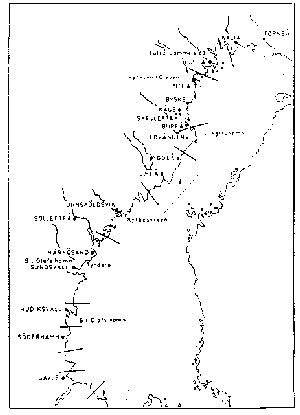
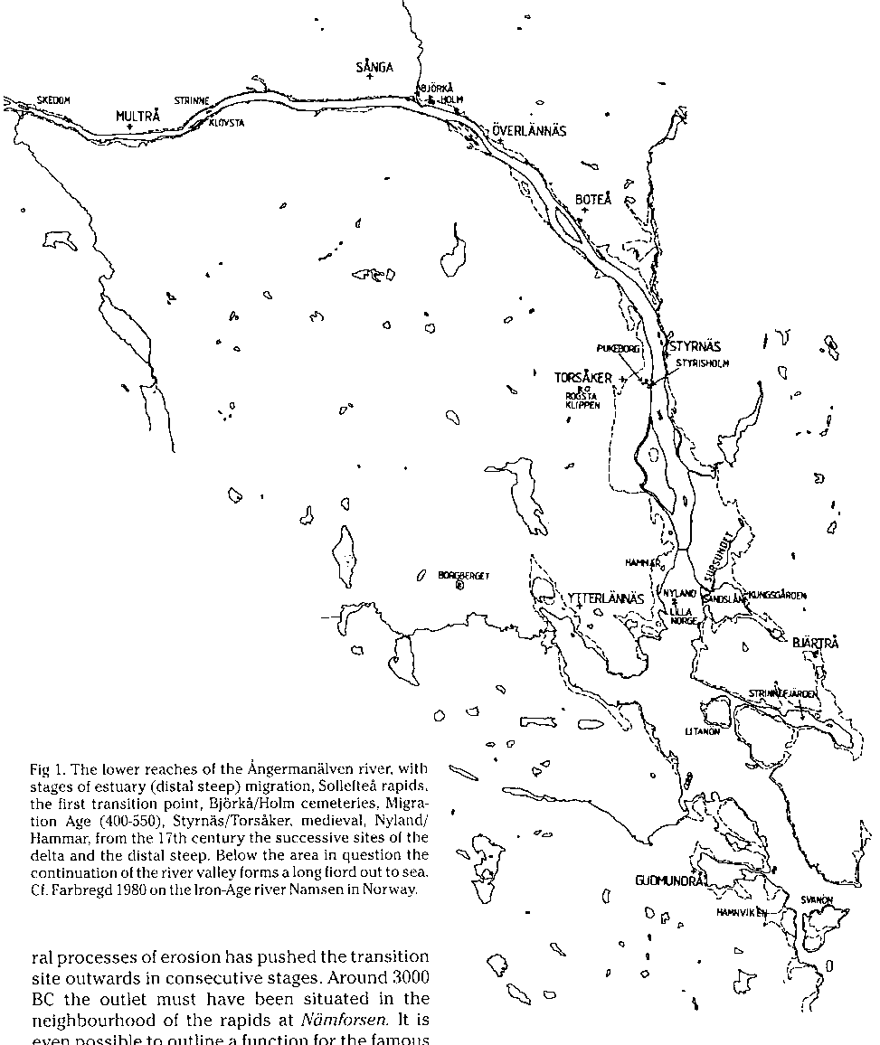
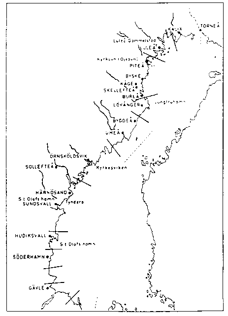
fig 1: The lower reaches of the Ångermanälven river
with stages of estuary (distal step) migration
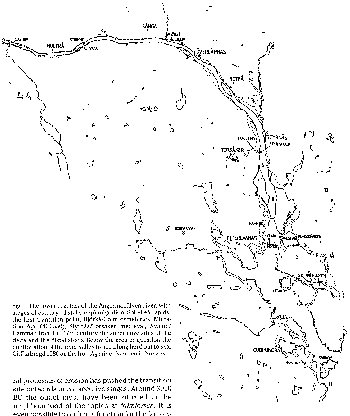 The present author will illustrate the system at the estuary or delta area of the Ångermanälven
river in middle Sweden (fig 1). Here the land upheaval together with natural processes of erosion
has displaced the transit site outwards in consecutive stages. Around 3000 BC the outlet must have
been situated in the neighbourhood of the rapids at Nämforsen. It is even possible to sketch
a function for the famous field of rock carvings in this light (Westerdahl 1991b).
The present author will illustrate the system at the estuary or delta area of the Ångermanälven
river in middle Sweden (fig 1). Here the land upheaval together with natural processes of erosion
has displaced the transit site outwards in consecutive stages. Around 3000 BC the outlet must have
been situated in the neighbourhood of the rapids at Nämforsen. It is even possible to sketch
a function for the famous field of rock carvings in this light (Westerdahl 1991b).
Somewhere later during the later part of prehistory the estuary must have been situated at
Sollefteå. Even in recent times the rapids here were the limit for the navigable reaches of the
lower river. These two sites, the rapids of Nämforsen and Sollefteå, form the first and second
transit points (Swed. brytpunkter ) of transportation in the river during historical
times (Westerdahl 1989a: 219).
During the Iron Age (c AD 500, Migration Age) it appears as if the richly furnished barrow
cemeteries of Holm and Björkå indicate the site of the river estuary, possibly of delta character.
In the Middle Ages the Torsåker/ Styrnäs area takes this place. Here the northernmost medieval
castle of Sweden proper, Styrisholm, was erected on an island in the delta (e g Wallander 1989). On
the other side of the river arose the remarkable double towers of a church, Styrnäs, by analogy
indicating a deanery and originally possibly part of a royal mansion. Place names and ancient
monuments indicate the multi-facetted functions of a central place. During the 17th century up to
recent times the outlet of the river has been Hammar and Nyland.
It seems that this pattern generally belongs to the estuary area of a navigable river. The basic
prerequisites for the significance of harbour techniques as the origins of settlement have been
outlined by Ellmers (1978). A general survey on riverine aspects of Iron Age archaeology in south
Scandinavia was delivered by Hårdh (1986). But only the advantageous process of land upheaval in
the Baltic north makes for a chronological differentiation in space which enhances the pedagogical
value of this demonstration. I have chosen to characterize the estuary area as one of the
prototypes for the classification of maritime cultural centres (e g Westerdahl 1989a, with
refs; Engl summ p 314). Thus, there is also a meaningful relationship to central places of the
land.
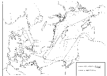
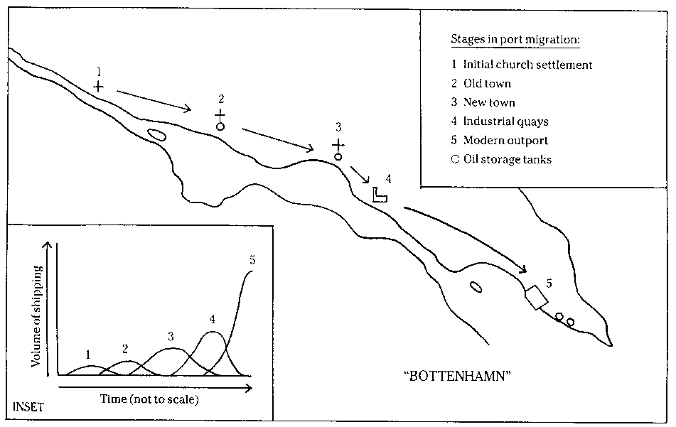
fig 2: The Bottenhamn model, according to Ian Layton
 The migration of town ports and their predecessors downstream a northern Norrland river has been
well illustrated by the Bottenhamn model of Ian Layton (fig 2, cf Layton 1981). However,
there is of course no immediate adaptation to the land upheaval. The central sites remain for a
long time before being moved to the new place. It is also reasonable to assume that the transit
site originally is situated a certain distance upstream from the distal steep. The term distal
steep (Swedish distalbrant) applies to the area where the fresh river waters mingle with
the salty -here rather brackish- water of the sea. The sedimentation of coarse riverine material
stops at this locality and the natural land forms of the bottom takes over. In this case with its
dramatic bedrock topography the distal steep today sinks down to 35 m or more below sea level
(Arnborg 1958-59). This is the area where the inland boat types meet those of the coast, to provide
reloading to types better suited to the following zone of transportation.
The migration of town ports and their predecessors downstream a northern Norrland river has been
well illustrated by the Bottenhamn model of Ian Layton (fig 2, cf Layton 1981). However,
there is of course no immediate adaptation to the land upheaval. The central sites remain for a
long time before being moved to the new place. It is also reasonable to assume that the transit
site originally is situated a certain distance upstream from the distal steep. The term distal
steep (Swedish distalbrant) applies to the area where the fresh river waters mingle with
the salty -here rather brackish- water of the sea. The sedimentation of coarse riverine material
stops at this locality and the natural land forms of the bottom takes over. In this case with its
dramatic bedrock topography the distal steep today sinks down to 35 m or more below sea level
(Arnborg 1958-59). This is the area where the inland boat types meet those of the coast, to provide
reloading to types better suited to the following zone of transportation.
It is not a primary concern for us here to identify material evidence of boats with historical
names of vessel types. The preliminary ambition is only to differentiate between the vessel
types used.
For the upper reaches of the river it can be surmised that the Saamish sewn boats (håp,
derived from Finnish haapio, South Saamish vints) were used (Ehrenmalm 1743; Korhonen
1982a, 1982b, Westerdahl 1987). Their area of action would be restricted to the river valley north
of Nämforsen. In the 18th century it was displaced even further upstream, pari passu the process of
colonization (Ehrenmalm op cit: 96f). During that time the three-straked boats of the farmers took
over below the market site of Åsele. Below Sollefteå a certain boat type had been constructed for
the transports on the main river current down to the distal steep, the co-called haxe
(derived from Finnish haaksi). At the reloading point sea-going vessels took over the cargo.
The curious fact is, however, that the term haxe seems to have migrated or rather to have
been extended to the later vessel type. This brings into focus the cleavage of transport patterns
north and south of the province of Ångermanland (below: and Friberg 1951, 1983).
The haxe is first mentioned in 1556 in the parish of Torsåker, at that time the main
transit area immediately upstream of the distal steep. No other parish in the province has got a
haxe on this occasion, which is an official account of vessels available in the county. The present
author imagines that this is the first regular indication of reloading in Norrland, since
the specific function of the flat-bottomed haxe in the area henceforward up to the end of
the 19th century is the transport of goods from the river area down to the reloading port of the
estuary and back. Everywhere in Sweden except in Norrland the term refers to a Finnish-built ship.
The intricate pattern of time-bound attributions of the vessel type name well illustrates the
problems of the identification of boat types referred to above.
Another example of a local transport zone in connection with a spacious estuary or delta area is
the Vistula lagoon. The mostly protected waters between Gdansk (former Danzig), Elblag
(Elbing), Kaliningrad (Königsberg) and its outport Baltijsk (Pillau) in the southern Baltic Sea
were plied by the characteristic flat-bottomed bording boat type. The bording is
mentioned in this area from AD 1270 onwards (Ellmers 1972: 13ff). Its skippers formed a particular
guild of the Gdansk/ Danzig township in historical times. Obviously the term bording is
derived from, the Scandinavian term byrdingr, which seems generally to denote a small cargo
ship during the early Middle Ages (10th-12th centuries AD, not the least used on Gotland: the
Skuldelev 3 find seems to be of this type). The function of the bording has thus largely
been to provide transport from the rivers on the lagoon for reloading to sea-going vessels. This is
a slightly different adaptation than in the case of the haxe of Ångermanälven. Nevertheless,
the bording type is easily discerned in pictorial representations and would probably
be so if found under water.
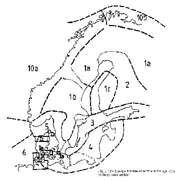
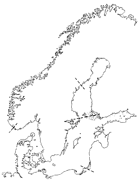
Transverse border zones
fig 3: The transverse cultural
borderline of central north Sweden.
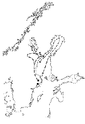 In a recent discussion on cultural boundaries within the north (Edlund /ed/ 1994) the present
author has outlined such a border zone (fig 3) in the northern part of the province of Ångermanland
(mostly referring to Ångermanland nolaskogs, i e north of the Skuleskogen coastal forest,
although the zone extends southward to the Ångermanälven river valley; Westerdahl 1989b, 1994c in
press). This border zone has a direct connection with transport geography.
In a recent discussion on cultural boundaries within the north (Edlund /ed/ 1994) the present
author has outlined such a border zone (fig 3) in the northern part of the province of Ångermanland
(mostly referring to Ångermanland nolaskogs, i e north of the Skuleskogen coastal forest,
although the zone extends southward to the Ångermanälven river valley; Westerdahl 1989b, 1994c in
press). This border zone has a direct connection with transport geography.
To the north of the zone long-range communication was in historical times almost exclusively
upheld on water by farmers and town merchants in summer, by way of ships and boat types designed
for this purpose. This concerned both transports to the inner Bothnian and from it. South of the
zone the farmers of historical times brought their produce to the southern parts, such as
Stockholm, in sledges on winter snow and ice.
This pattern can already be discerned during the Middle Ages in the voyages of examination in
Norrland by the Catholic archbishops of Uppsala. They always went along the southern coast and
inland by sledges in winter, but never north of the parishes Nora and Nordingrå in Ångermanland.
The churches of the inner parts of the Bothnian, on the other hand, were examined only by way of a
ship voyage in summer directly to the northmost river valleys (e g the Torne river). The
archbishops dealt with all the current parishes on the way back, even some south of the zone of
transition indicated above (Friberg I 1951: 88ff with map p 90). The prelates accordingly only
followed the contemporary pattern of transportation. The boat terms epitomizing in historical times
the two zones of the Swedish north would be the haxe for the southern, restricted, zone and
the färdbåt/fälbåt -later specialized for sealing- for the thorough-going route from the
extreme north (below). The ship type/s/ of the archbishops was probably of another, more regional,
i e less local, character.
The ethnologist Phebe Fjellström has, moreover, observed and tentatively described a cultural
borderline north of the Skellefteå river, indicating West Finnish presence and, to some extent,
colonization, during the late Iron Age and the Early Middle Ages. This influence is undoubtedly to
understand in maritime transport terms (Fjellström e g 1987, 1988).
Possibly the boat term epitomizing this zone would be the karvas / karbas, with the
implications inferred by Korhonen (1987; with a Germanic lineage for the term). This inland rowing
boat type evidently was adapted for hauling and carrying at portages.
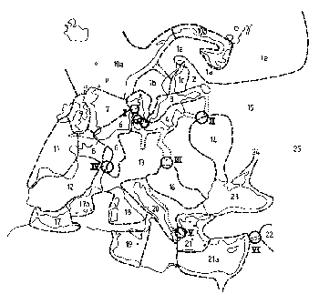
Longitudinal border zones
fig 4: Longitudinal transport zones of northern Ångermanland.
 The cultural elements used to describe the transverse border zones above reveal that the land in
general could be subdivided along its longitudinal axis, at least during the Middle Ages (northern
Ångermanland, fig 4):
The cultural elements used to describe the transverse border zones above reveal that the land in
general could be subdivided along its longitudinal axis, at least during the Middle Ages (northern
Ångermanland, fig 4):
1) The waterfront zone
This zone is extended conventionally 1 km inland from regular waterways. The processes of land
upheaval determine the details and the subsequent shrinkage -or displacement- of the zone. This
corresponds to the Iron Age agrarian colonization zone of Norrland. Generally speaking, this zone
displays approximately the same cultural pattern along the whole coast of Norrland, as expressed in
vernacular boat-building from the island Singö in Roslagen, Uppland (Klein 1933: 306). This
maritime cultural region could, if other elements be taken into consideration, be subdivided
into smaller maritime cultural areas (e g Westerdahl 1980: 10f). However, the aspect of
local subdivision does not concern us further in this context, except as an indication of local
transport zones (fig 5). Common traits are furthermore to be expected with the whole of
Scandinavia and even with the Baltic region in general, The unifying factor can obviously be
interpreted as long range shipping, fishing and hunting during the Viking Age and forward. All
maritime cultural centres are of course to be found within this zone. Innovations and news would
have reached the zone not much later than Stockholm or Danzig (Gdansk).
2) The coastal zone
It is interpreted as the agrarian colonization zone, in the Middle Ages extending
to a general transition approximately 40-50 kms from the coast, as the crow flies, interspersed
with strong elements of hunting and fishing. The agrarian area is established by way of the first
complete land registers from the 1530´s onward. The coastal zone thus seems to be identical with
the area of medieval colonization. The purely agrarian elements seem, however, to be concentrated
very close to the coast, just a few tens of miles inside the waterfront zone. In the interior parts
of this zone is found at least one of the transverse cultural borderlines within upper
Norrland referred to above, i e in northern Ångermanland.
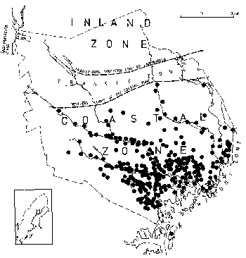
fig 5: Maritime cultural areas and local
transport zones of the Norrland coast.
 3) The inland zone
This comprises an immense area of a depth of about 400 kms across Scandinavia. This zone largely
appears to incorporate nomadic or seminomadic cultural elements found much farther northward and
eastward, and is accordingly to be interpreted in general as a counterpart to the long-range
relationships of the waterfront zone. In this case, the unifying factor must be attributed to
traffic on snow and ice during the winter. In summer waterways were mostly utilized in a transverse
pattern, following the rivers and lake systems, except along the mountain ridges, where the
longitudinal crossings from one river valley to another reappear from the pattern of the
waterfront. In this case material for study has been supplied by historical sources and oral
tradition. Certainly subdivisions in this respect might be found also here, but it is not the
concern of the present study. The inland zone was first colonized, by agrarian settlers from
within, as well as from the outside, after AD 1674, most of it in fact from the 18th century
onward.
The zonal pattern is illustrated by fig 4 at the transverse cultural border zone of northern
Ångermanland, covering more than 100 kms inland. This pattern shows variations, but the current
area is a singularly suitable example along the Norrland coast. Transit zones of
transportation are indicated, not only at the rivers but also at the end of lake systems. It is
possible, that hunters/ exploiters from settled areas, even used an amphibian system, where vessels
were left at points or even rebuilt to sledges for the advent of winter conditions. This might be
the origin of the boat-like Laplander´s sledge and one of the reasons for the survival of
sewn boats, which could be disassembled, carried in parts and, as above, rebuilt (note
2). Sites of local markets are found in the current transit zones in historical times.
The relationship of these inland transport zones to medieval boat types thus appears to be
fairly clear:
a) Waterfront zone: Sea-going, decked or partly decked, sailing vessels, originally
applied from the outside. Possibly called skuta (Olaus Magnus 1555:4.10) or, in the case
of the northern zone, färdbåt or fälbåt, literally `travel boat´(the term surviving
as the name of the sealing boat of historical times).
b) Coastal zone: Undecked working boats of a local character with square sail on a
single mast, up to 12 m length, probably called haxe in an early stage (first mention at
the Ångermanälven river in 1556), occasionally for sea transport.
c) Inland zone: Saamish sewn river boats (håp, vints), even used in moderate
rapids, of the traditional type, carried overland at portages by a single rower. The
bulkhead-like stem and stern ribs were later transferred to the boats of the colonizers
(Westerdahl 1987, 1988, 1994a in press). In the 18th century iron rivet fastenings rapidly
replaced sewing. These boats were often built along the upper reaches of the rivers, left or sold
at the transit points downstream and never brought back. They may therefore for a long time have
constituted a considerable part of vessels available in the estuary area of the coastal zone. The
cross-country conveyor adapted for calm waters in the northeast (zone 2 below) would possibly be
called karvas/ karbas (Korhonen 1987).
Largely, details of construction in these vessel types adapted for their transport zones remain
for analysis. In some better known cases indications have been made (e g the southern Saamish river
boat; cf Westerdahl 1987). However, every detail could not be expected to give functional
information. Tradition, confined to local areas -sometimes, but not always, to local transport
zones- and to local boatbuilders, always has taken its toll.
Maritime itenaries and transport zones
During the Viking Age and the Middle Ages a few maritime itineraries give other information than
is available in other material on the sailing routes. The first mention concerns Ottar´s voyage c
AD 900 from Hálogaland in north Norway by way of the market of Kaupang (Skiringssal) south Norway
down to Hedeby (Haithabu) in Slesvig, south Jutland (Lund, ed 1984). Maybe this could be considered
to reflect a transport zone in the Viking Age. It is to be surmised that this is not the only
instance of the use of this route, even by Ottar himself. A reconstruction of the (night) ports of
call of Ottar in south Scandinavia has been made by Crumlin Pedersen (1984, on material from e g
Ekblom 1940). An alternative, although less likely, route is proposed by Schnall (1981). The North
Norwegians´ route to the south shrunk considerably during the monopoly of the Hanseatic merchants
at Bergen, corresponding to the Bothnian trade restrictions in the northern Baltic.
The second mention appears in the same text. Wulfstan records a voyage from Hedeby along the
coast uninterruptedly to Truso (probably Janów Pomorski at lake Druzno in present-day Poland:
Jagodzinski 1988), i e without any calls, presumably at a safe distance from the coast, as
indicated by the sounding lead (Crumlin-Pedersen 1984). This may also represent a stage in the
turn-over of the riches of Central and Eastern Europe along the Wisla river system by way of the
Elblag tributary outlet.
fig 6: The coastal route of the land register of king Valdemar
 The next case is the itinerary in King Valdemar´s Tax Register of
c AD 1300 (fig 6, cf Westerdahl 1990) which covers the stretch from Blekinge, at that time a part
of Denmark by way of the Swedish southeast coast to the Sea of Åland and Reval (Tallinn) in the Bay
of Finland (here called mare estonum: `the Estonian Sea´). It is very probable that Scania,
where this itinerary seems to start, represents an important transit zone. Sailing past the justly
feared Horn of Scania at Skanör/ Falsterbo, the origin of the very name Scania and
Scandinavia (original Latin form Scadinavia, from Germanic ´scathan-auju`, "Damage
Sands", cf Svennung 1963), has been avoided. Ships were intended for and constructed to reach this
point but not further into or out of the Baltic during the great herring fisheries and markets of
the 13th and 14th centuries. Possibly this is even the origin of the term for the later ship type
scho/o/ner (´ship /bound/ for Scania´, Dutch Scho/o/nen).
The next case is the itinerary in King Valdemar´s Tax Register of
c AD 1300 (fig 6, cf Westerdahl 1990) which covers the stretch from Blekinge, at that time a part
of Denmark by way of the Swedish southeast coast to the Sea of Åland and Reval (Tallinn) in the Bay
of Finland (here called mare estonum: `the Estonian Sea´). It is very probable that Scania,
where this itinerary seems to start, represents an important transit zone. Sailing past the justly
feared Horn of Scania at Skanör/ Falsterbo, the origin of the very name Scania and
Scandinavia (original Latin form Scadinavia, from Germanic ´scathan-auju`, "Damage
Sands", cf Svennung 1963), has been avoided. Ships were intended for and constructed to reach this
point but not further into or out of the Baltic during the great herring fisheries and markets of
the 13th and 14th centuries. Possibly this is even the origin of the term for the later ship type
scho/o/ner (´ship /bound/ for Scania´, Dutch Scho/o/nen).
In the opinion of the present author, this part of Øresund was avoided otherwise. Instead the
principal routes into the Baltic went by way of the Danish isles: Storstrøm/ Ulvsund to the channel
of Nyord and Ulvshale at the tip of Møn island, the latter mentioned as ulfshala on a late
11th century Gotlandic rune stone (Stenkumla nr 207: Jansson et al, 1978:198ff), and further on
directly to the obvious passage between The Sand Hammer (Sandhammaren, SE Scania) and The
Rock Hammer (Hammeren, Bornholm). The Grønsund or Guldborgsund passages were chosen into
or out of the southern Baltic/ Vendland.
The itinerary of king Valdemar may therefore represent another main zone of transport geography
in the Baltic of the 10th-14th century, even if transports often went by the open sea and not only
hugged the coast closely as indicated by the place names of the text.
The pivot of Denmark
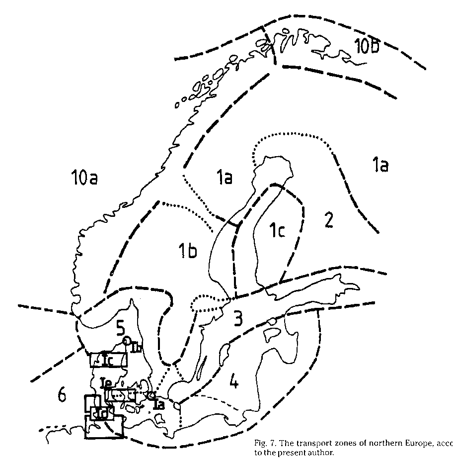
fig 7: The transport zones of northern Europe
 Denmark (with Scania) generally forms the most important transit zone or region during the early
Middle Ages. (Fig 7). This situation also gives a prominent reason for the maritime
importance of the Danish realm in the north. Part of statehood -not only in the north- is the
establishment of safe and controlled routes on land and at sea. It may be that the chronology of
piling barriers and sacrificial finds of Jutland indicate that the roots of protostate Denmark is
to be found along the Lille Belt. If so, it may be interesting to test the hypothesis that this
maritime control centre travelled successively eastwards with royal power, in the 12th century to
be found at the Store Belt/ Storstrøm region to the southwest of Zealand and finally comprised the
Skanør/ Falsterbo market point with the attendant control of The Sound (Øresund), stabilized as the
royal customs at Helsingør/ Elsinore in the Late Middle Ages. The central position of Denmark thus
in many ways reflects the position between those two seas or zones, the Kattegatt/Skagerack and the
southern Baltic. But Denmark is indeed a triple pivot. The third sea or zone is the North sea. This
fact was pointed out by Ole Crumlin-Pedersen in his well-founded motivations for the establishment
of the Center for Maritime Archaeology of the National Museum, of which he is now the director.
Denmark (with Scania) generally forms the most important transit zone or region during the early
Middle Ages. (Fig 7). This situation also gives a prominent reason for the maritime
importance of the Danish realm in the north. Part of statehood -not only in the north- is the
establishment of safe and controlled routes on land and at sea. It may be that the chronology of
piling barriers and sacrificial finds of Jutland indicate that the roots of protostate Denmark is
to be found along the Lille Belt. If so, it may be interesting to test the hypothesis that this
maritime control centre travelled successively eastwards with royal power, in the 12th century to
be found at the Store Belt/ Storstrøm region to the southwest of Zealand and finally comprised the
Skanør/ Falsterbo market point with the attendant control of The Sound (Øresund), stabilized as the
royal customs at Helsingør/ Elsinore in the Late Middle Ages. The central position of Denmark thus
in many ways reflects the position between those two seas or zones, the Kattegatt/Skagerack and the
southern Baltic. But Denmark is indeed a triple pivot. The third sea or zone is the North sea. This
fact was pointed out by Ole Crumlin-Pedersen in his well-founded motivations for the establishment
of the Center for Maritime Archaeology of the National Museum, of which he is now the director.
The political aspects of the control of these maritime "watersheds" could well be compared to
the inland extension of the first Russian (the Kievan Rus etc) states precisely to the real
watersheds (Nozov 1992)
Transports from the Rhine end up at the Elbe or at the narrowest part of south Jutland and are
reloaded for the Baltic in Hedeby or Slesvig. The route corridor to Jutland proper ends up at Ribe,
one of the earliest market towns of north Europe during the 8th-9th centuries. Certain cargoes may
have passed northward through the Limfjord bay (or channel) to the other side. Unfortunately
it could only be used by shallow-draft vessels, unsuited for heavy cargoes and for sailing the
Atlantic. This route was closed for a many centuries by sand around 1150. But the Skaw (Skagen) was
still avoided. Then, in the first part of the 13th century, the "ummelandsfarer" ("those who travel
round the land") are mentioned for the first time (privileges for the Scania market by King Abel of
Denmark) in 1251 and it is no coincidence that the cogs ("duo
coggonibus") are mentioned for the first time in AD 1202 in connection with a siege of Riga in
Livonia (Westerdahl 1990: 358).
It seems therefore appropriate to assign the ship type name cog (Kogge) precisely to the
zone of transport geography from the delta mouth of the Rhine and attendant rivers to Jutland
(Crumlin-Pedersen 1965, 1983a). Traffic from the Baltic usually ended up for turn-over and
reloading at the paramount depot of Bruges/Sluys ("zincfal in flandriam" in the
Mediterranean itinerary of Adam of Bremen; scholion c AD 1100; 1978: 437). Mediterranean cargoes
did neither go further. The break-through of this zone was made only during the 15th century, when
the Bruges entrepot successively lost its importance. The symbolic ship type of the new transport
zone uniting the Mediterranean and the Baltic may perhaps be the holk (hulc) or the nao/
caraque. It is maybe proper to use a Romance term, but it is possible that the ship type in
question was in fact an amalgamation of northern (lower hull clinkered?) and southern (rig?)
influences. The remainder is in essence the technology of the three-masted ship and of regular
navigation in the High Seas.
The other late medieval transport zones of northwest Europe are partly indicated by the Low
German "Seebuch" (fig 6, cf Koppmann 1876) of the 15th, partly the 16th century. A number of
breakthroughs of zones were directly related to economic and political developments. Certain
zones could even be barred by monopolies or other administrative action. In a Bothnian
context we find the so-called Bothnian trade restrictions, which limited the radius of legal action
to the maritime space north of Stockholm or Åbo (Turku) in Finland. We have already mentioned the
impact of Hanseatic trade as well as transport monopoly in Norway. This complex is however not
the immediate concern of the present study.
As to the Mediterranean the present author would like to refer to the fascinating work on the
times of Philip II of Spain by Fernand Braudel (1972). The long perspectives offered by those minor
seas within the Mediterranean are to a degree directly relevant for the theme of this study. Also
here characteristic ship types for each zone are mentioned by Braudel (op cit, Ch 2, Seas and
Coasts, and passim: here fig 8).
The north and the south thus mingle to form a maritime archaeological material to reflect the
useful concepts la longue durée and also les conjonctures of the Annales School (cf
Knapp /ed/ 1991)
It would be interesting in the future to contrast the two concepts of maritime and other
cultural areas/ regions and zones of transportation . The present author is convinced
that a study of this holistic nature is of much avail to understand to what an extent -if at all-
maritime culture is different from an inland-bound cultural concept. And apparently such an
undertaking will also help us to understand how cultural relationships on land are dependent on
maritime transport zones with corresponding boat types.
List of preliminary transport zones of Europe
fig 8: European transport zones
 It should be noted from the beginning that a cartographic representation of such a dynamic element
as the transport zones will inevitably make for simplifications and downright "mistakes" (although
some of them are more or less intentional). Moreover, the almost inevitable mixture of cultural and
transport traits makes it difficult just to cultivate the transportation aspect. Moreover, many
maritime borders must be represented too far inland just for convenience. At best, the result of
this stage of the demarcation work illustrates the difficulties of the concept rather than the
petrification of borders. Borders are always to be looked upon as areas, not solid lines on a map,
where several layers of transport patterns display variable limits. Smaller zones, such as that of
the bording (above) or other long-distance ferrying, are not outlined at all, not to confuse
the picture. Note the central pivots of Denmark and Greece and other central transit areas inland
(Roman numerals).
It should be noted from the beginning that a cartographic representation of such a dynamic element
as the transport zones will inevitably make for simplifications and downright "mistakes" (although
some of them are more or less intentional). Moreover, the almost inevitable mixture of cultural and
transport traits makes it difficult just to cultivate the transportation aspect. Moreover, many
maritime borders must be represented too far inland just for convenience. At best, the result of
this stage of the demarcation work illustrates the difficulties of the concept rather than the
petrification of borders. Borders are always to be looked upon as areas, not solid lines on a map,
where several layers of transport patterns display variable limits. Smaller zones, such as that of
the bording (above) or other long-distance ferrying, are not outlined at all, not to confuse
the picture. Note the central pivots of Denmark and Greece and other central transit areas inland
(Roman numerals).
1a. Zavoloshe. The inland zone of subarctic northern
Fennoscandia and Russia north of the portages (Russ. volok). The consequences of the
topography and the constant differences between summer and winter traffic are more obvious than
elsewhere.
1b. The inland zone of central Sweden and Norway, to some extent corresponding to 1a, but more
adapted to slowly running waterways than parts of that zone. Portages abound, nevertheless. To this
zone belong extensive lakes.
1c. Western Finland with its river and lake systems, around the fundamental portage of
Maanselkä, The Land Esker, largely heading westwards. More or less a by-product of the other zones.
On this map the area is sketched a little too schematically.
2. The area upstreams Maanselkä, and the transport corridor along the large lakes north from
Ladoga by way of e g Oulunjoki (Ule älv) to the inner Bothnian and partly inland. May have been
used much earlier than the Carelians proper, e g by prehistoric Comb Ceramic (or other
Proto-Fenno-Ugrian(?)-speaking) groups.
3. "Ostsæ/ Eystrasalt". The maritime transport zone along the Swedish eastern coast by way of
Åland to the Finnish Bay. Indicated partly by the itinerary from Utlängan (utlengi) i
Blekinge to Reval (ræueælburg, presently Tallinn) of the tax register of King Valdemar Sejr
of Denmark (dated c 1300; cf Westerdahl 1990). This is, in part incidentally, the main Swedish axis
of expnsion during the Middle Ages (e g Klinge 1984), but also a cultural communication line in
prehistory, both ways. This zone is divided in the south, by way of Bornholm, and communicates
neatly with 4. On the lie Gotland and Hiumaa (Dagö), which probably both represent transit points.
The dominant position of Gotland in Baltic prehistory may thus partly represent a transportation
pattern, the island facing two major zones. This zone is the main model for the coast-hugging
character of traditional maritime zones. It is not intended, however, to be identical with one
single sailing route.
4.The "Beltic" sea/ zone (see Svennung 1953). The southern zone of the Baltic, from the Danish
islands and the present-day coasts of Germany, Poland and the Baltic countries up to the Gulf of
Riga/Hiumaa, can be subdivided at the level of Bornholm. The early central position of that island
seems to be largely overlooked, were it not for the extremely interesting Germanic Iron Age site of
Sorte Muld. The brief itinerary of Wulfstan c 900 from Hedeby to Truso in the delta area of
the Wisla represents an obvious illustration of the zone, but also the traditional routes across
the small inner sea between the Danish islands and the southern Baltic coast. This is the main
expansion axis of the Danish realm during the High Middle Ages, but with an obviously much older
ancestry. The transit points seem to be situated in the Belts and along Skåne (Scania).
5. "Westsæ", Kattegat/ Skagerack, the second `sea´ of Danish kingship, with cultural
predecessors at least back to the Pre-Roman and Roman Iron Age. Transit points in the north at
Lindesnes and Lista in Norway (northern limit of recent boatbuilding traditions, using treenails
instead of nails, in west Sweden/ north Jutland/ south Norway). Included in the zone are the areas
around the largest lake of Scandinavia, Vänern, east (and parts of west Jutland, with a temporarily
passable transit area at Limfjorden) and the central part of south Norway (Viken). The justly
feared Skaw (Skagen, transit point Ia) is doubled by regular shipping at first in the 12th century.
The zone corresponds with nr 4 mainly at the transit point of Falsterbo/Skanör (Ia) with its
extremely dangerous reefs, making for exchange passing from two havens on either side of the
isthmus. In a larger perspective the whole land barrier of the Danish islands (cf the position of
the early Roman Iron Age trading place Lundeborg/ Gudme on the Great Belt; Thomsen 1992, Thomsen et
al, 1993) with Scania (perhaps as a whole; cf Fabech 1993) appears as transit points (Ie).
6. "Nordsæ." The zone between southern Jutland and the Rhine and Schelde estuaries, including
the river systems up to Switzerland. A model zone for the hypothesis by way of the analysis of
ancestry of the cog, as it appears already in the classical work by Ole Crumlin-Pedersen (1965), a
river ship type first adapted for the Channel and later for coast-hugging routes of the North Sea.
If there was an open passage at Limfjorden it may have made possible the direct route to zone 5,
but normally land transport followed somewhere below the root of Jutland (transit point Id; a more
complex picture than presented hitherto appears in Crumlin-Pedersen 1992). The outlet of west
Denmark (Jutland) clearly has been found at Ribe, and this town plays a fundamental role in the
area even during the High Middle Ages. Ultimately in the 12th century Limfjorden is definitely
closed (once more) and the Skaw is rounded by the first ummelandsfarer. It thus
possible that the variable conditions of the sandy tongues of the western Limfjorden entrance may
have determined the areas of this zone. The present author feels, however, that the distribution of
certain long distance find categories in the Pre-Viking Iron Age indicates that the zonal pattern
must be considered rather final. The cog-initiated hypothesis gives a good case for the dynamic
character of transport zones in general, particularly since Crumlin-Pedersen is able to show how
the construction of the ship type adapted to this zone (6) changes at the stage of the
ummelandsfarer. But the suggestion that this is due to the new surroundings in the Kattegatt/
Skagerack or the Baltic does not necessarily follow. The dominant idea is that the cog receives its
new traits from Scandinavian ship building traditions in zone 5, but no scientific reason has so
far been offered for the take-over of technical traits. Admittedly there is also a problem in the
lack of intermediate stages between the Roman time river ships and the medieval cogs.
7. The North Sea with western Britain and its corridors to west Norway. This zone appears as a
kind of byproduct, having delineated the others, but seems to be a fairly common route corridor
westwards in Nordic literature (e g Stokoe 1957).
8. The northern French rivers systems, the south part of Britain and the south part of the
Channel.
9. The Irish Sea, originally based on common cultural tradition among the Celtic peoples.
10a. The Norse utleid corridor to the northern Isles (Scotland), Faroes, Iceland and up
to Finnmark in the north. The traffic of the north part was later monopolized to Bergen by
Hanseatic merchants in the 14th century onward.
10b. The Pomor zon, with the White Sea. Border area north of Lofoten islands, rather than the
administrative border between north and south Halogaland, at Brennesund (Norden Breanda in
1356; cf Urbanczyk 1992: 11).
11. South Ireland, Cornwall/ Devon, Bretagne and north Galicia. Cultural connections.
12. The inner parts and rivers of the Iberian peninsula and S France (but with the Basque
territory coast), which as to what concerns inland conditions could be subdivided along the
Pyrenees.
13. Central Europe with the major rivers of the Elbe, the Oder (Odra) and Wisla (Vistula).
Transition point (III) between Wisla and the Danube in the Carpathian mountain area.
14. The Dnepr river zone with corridors to Volkhov-Ladoga-Neva in the north and to the southern
Dvina to the south Baltic (transit point II- Smolensk), uniting the Baltic with the Black Sea (the
road of the Varangians of the Nestor chronicle).
15. The inner Russian zone, including the Volga with its transit points towards the White Sea,
and its run towards the Caspian Sea (25; further according to Kerner 1946).
16. The Danube river system uniting central Europe with the Black Sea. Transit point III to
northern central Europe.
17. The south Iberian peninsula with present-day Morocco/Maghreb (the Arabic West).
17a. The inner sea of western Spain with the Balearic islands united since Roman times with the
Saone/ Rhone river systems of France, with transition area to the Rhine (IV) in Champagne (the site
of the high medieval markets: no coincidence), uniting the Mediterranean, the Channel (by way of
the area of Seine/Oise/Marne (zone 8) North Sea, and the Rhine (zone 6).
18. The inner sea triangle of west Italy, Sardinia, Corsica and the coast west of the maritime
Alps, with connection to France and central Europe.
19. The inner sea square formed by Roman Africa/ Tunisia, with the Djerba islands, Sicilia and
the south tip of Italy.
20. The Adriatic inner sea with the Po valley plain along the east coast of Italy and the
northern and western Balkan lands down to western Greece.
21. The Aegean inner sea, with the Dardanelles and present-day west Turkey. Transit point to
zone 20, the Corinthian isthmus (V)- and in the south Cape Maleas and to some extent Crete.
21a. The Eastern Mediterranean inner sea, with south Turkey, Cyprus and the west part of the
Fertile Crescent, beautifully described with parts of 21 in the route taken by the Ulu burun
ship wreck of 1.400 BC (SW Turkey; Bass 1987), but equally valid and described with the same limits
by Braudel (1972/1986) for the late 16th century AD. Fundamental transit area to Mesopotamia (the
Tigris /Euphrates river plain and the Persian Gulf) by way of the Orontes valley (the Naharina;
VI).
22. Mesopotamia. Transit points to the Mediterranean in the Naharina (VI).
23. Black Sea. A self-evident zone, but delimited or subdivided by e g the zones of the Danube
(16), Dnepr (14) and Don/ Donets (24) river systems.
24. The Don/ Donets.
25. The Lower Volga and the intricate transport pattern of the low-lying steppe and loess plains
west of the Ural mountains. Several transit areas, e g to 14 (Dnepr), 1a (to the White Sea etc). |


 Back to Nordic Underwater Archaeology