On the Significance of Portages
– a survey of a new research area
|
Monuments in the landscape and landscape
portals – Transit points in transport zones – Meeting places, nodes of power and
control of transportation – Catalysts of the adaptation of
transport vessel types and techniques – Watersheds in the cognitive
worlds of ”mobile Man.” The phenomenon that we are going to treat here, French and English portage, in Nordic languages, Norwegian eid, Swedish ed, with a basis in a watershed, is spread all over the world. It expresses a pluralism of significances. It has got natural prerequisites as a portal of the landscape and as a cognitive border of human activities. In addition it has always in the past had great importance in transportation and thereby in the exercise of power, together with various other aspects of human culture. In some areas, including most of the coast of Norway sites of portages have been an integrated part of oral tradition, some registered, some still unregistered. The everyday context is the land roads and the traffic and transport on waters, almost exclusively in small boats. But not all potential portages were used. A solely functionalistic explanation of their use is insufficient. Their actual use is a product of cultural patterns and cognitive systems. It is possible to see the portages as a inverted picture -an inverted mirror- of the sounds or canals and their ferries (Rogan 1984): the portages are to the water routes what the sound is to the land roads, an obstacle that has been overcome by way of various devices. Different types of authorities, from chieftains to kings, have influenced the use of the portages for their own benefit and control (cf Westerdahl 2002a). We can discover the functions of the portages already early in prehistory and the Middle Ages (e g. Clarke 1952, Simonsen 2002: 33f), by way of the Norse historical sources during the 12th and 13th centuries and at the end of the Middle Ages (t.ex. The Sagas of the Kings of Norway, Norges kongesagaer 1979, Olaus Magnus 1555; for comments to the latter Granlund 1947, 1976). Older archaeological datings are so far sparse. The portage at Tiltereidet in Sør-Trøndelag is by way of the wood of the hauling trail dated to the late Migration Age or the early Merovingian (500-600 e. Kr.; Smedstad 1988; BP 1470 +-70, kal. 532-645 AD). The canal across the portage Spangereid in Vest-Agder can by way of the process of land upheaval be dated even earlier (Stylegar/ Grimm 2003). Early settlement on a portage presumably gives indications of the first regular use of it. Eid- sites are typical of the Norwegian coast. They have been been observed fairly early by research in this country. The historian Yngvar Nielsen, thus states that they ”are a particularity at the Norwegian coast” (Nielsen 1905). The significance of the eid sites and the concomitant drag sites (hauling places) was however reduced by the arguments of Sverre Steen (Steen 1929). There is indeed common sense in this. Steen points out that according to historical sources the portages can only be proven to be used in exceptional situations. In certain local histories and the like can be traced a certain “overkill” on the historical importance of a site, if it carries the name of eid. At times it almost amounts to a myth. It is imperative, therefore, to reinstate a historical balance between the ”normal” coastal route and its alternative ramifications, largely for smaller vessels, where these sites have a definite, everyday, place. To bring this phenomenon back to that original significance is the aim of this conference. This view has been stressed recently by Povl Simonsen (2002). The local everyday type of drageid is represented e.g. in Trøndelag at the outer seaboard in Vikna, Flatanger, Hitra and Nærøy. The everyday character is stressed by the fact that the latter two lead to fresh water lakes. The portages were in fact used in this sense during late historical times (Simonsen op.cit.). Jakob Thode Ræder relates a personal transport in 1805 across Tiltereidet in Møre og Romsdal (Austigard 1976). The parson Hans Strøm mentions the important eid sites inside the justly feared promontory of Stadlandet, Sogn og Fjordane in his classical work on Sunnmøre in 1766, where the boat people “in particular during the winter...usually choose the land road across Eidene, of which there are 3.” Strøm call them Drags-Eidet, Sandviig-Eidet and Mands-Eidet (Part 2: 475f, ref. by Modéer 1936: 94f). These drageid were well-used also in the interior. In the border area between present Swedish Jämtland and Norwegian Trøndelag boats were dragged across “to Norway---(and) Sør-Lie parish”(Trøndelag) according to Abraham Hülphers in his description of Jämtland from 1773. The route went by way of the large lakes Hotagen, in Jämtland, and Rengen, which is on both sides of the border. Among Norwegian pioneers on portages in later times should be pointed our in particular Svein Molaug (1989: 185ff), Povl Simonsen (Simonsen 1970, 2002), Ingrid Smedstad (1988) with details of the history of land roads, and Pål Nymoen (Nymoen 1995, 1997). Simonsen has systematically accounted for 67 hauling places and a potential of altogether 107 in Northern Norway. Nymoen has found more than 500 relevant place names only by using the available place name registers in Norway. Swedish scholars have experimentally tried to find and to use portages sites in the interior of Russia and surrounding states since the 1980´s in order to sail vessels of Viking Age types all the way to Miklagård or Constantinople, present Istanbul. (Nylén 1983, 1987, Edberg /red/ 1996, Edberg 1998, 2001). The present author for his part recorded fairly early in his career the portages of the Swedish Baltic coast and in the northern interior of Fennoscandia (Westerdahl 1989b: 194f). This led me to critical comments on the experiments carried out in Russia (Westerdahl 1985a, 1996, 1998, 2002). In Vest-Agder, Norway, Frans-Arne Stylegar has in particular studied Spangereid, one of the most exciting and certainly most many-sided sites of this kind in Norway (e.g. Stylegar 1999, and comparative material in e.g. Stylegar 2002, Stylegar/Grimm 2003), but also the area of Harkmark (Stylegar 2001, Sveinall during this conference). The implications of the eid sites are indeed many-sided. In this survey some of these implications will be mentioned. It is quite feasible to introduce a new research theme. This is the first international conference on the subject and it is only fitting that is is being held i Norway. And in fact only fitting that the conference site is Vest-Agder: the point of departure is the famous site of Spangereid at the basis of the promontory of Lindesnes of European fame and Listeid inside the peninsula of Lista: The parson Peder Claussøn Friis (1566-1614), well-known for his classical description of Norway, tells us that boats were driven overland at the Listeid portage when tempests and bad weather in general made it dangerous or impossible to double the peninsula of Lista. The county governor Holm wrote in the Topografisk Journal in 1794 and 1795 that across this portage went the general route for all coming by boat from the north or the west. (Vest-Agder 1955: 469). There is a number of portages of more local importance in this county, e.g. Flikkeid and Drangeid north of Flekkefjord, Briseid as a continuation of Listeid along the ancient mail road, Rosfjordeidet in Lyngdal, where the conference hotel is situated, and that Eid which connects the inner parts of the Harkmark fiord to the sea (on which, as is mentioned above will be introduced by Paul Sveinall, Konsmo). In the neighbouring county of Aust-Agder could be mentioned the eid sites of Grimstad, the parish centre of Eide. These last sites will be presented by Johan Anton Wikander, Trondheim, at the conference. The underlying assumption is that the profusion of Norwegian -and other sites of the North -and the pioneering investigations of them would be able to produce prototypes and various relevant aspects of at least the European potential. Rationally speaking, if the rugged coasts and mountains of Norway have produced such a number of portages difficult and uncomfortable to ascend, not only with a boat, how much more should not the isthmi of flatland Europe have been used for portages in ancient times? Portages and amphibious ways of transports are cultural products. But the physical details of natural topography is always at the bottom of human movements in the landscape. EidEid is basically an appellative denoting a natural feature. In addition it is a place name element, occurring prolifically at the coast as well as inland. Accordingly we meet very frequently place names in the Nordic countries composed of the element Eid or Ed. As examples we could choose the Swedish Edsviken close to Stockholm or the well-known Eidsvoll along with the Swedish Edsvalla (Värmland), meaning the same. As the second element we know it from (Dals) Långed, Dragsed, Dragseid, Tiltereid. Alone it may appear as (Lilla) Edet, Ei(d)e, eller Ed. It should be observed that Lilla Edet (`the small portage ) at the Göta älv river in Västergötland presupposes Stora Edet (`the large portage´). The latter name has now disappeared in common use but it originally denoted the huge waterfalls at Trollhättan, once a wonder to Europe (cf Boman/ Westerdahl 1984). During historical times the land passage before the canals completed in 1799 has been called Edsvägen, `the portage road´(Lundén 1954). The small portage, Lilla Edet, is situated at a series of rapids. But also these had to be by-passed, either by towing the boats in calmer waters and/or by way of a land transport of cargo, crew and boats. Important examples in the east are the Finnish Hangö, spelled hangethe c. 1300 and Dagö (Hiumaa), DagaiÞi of the Guta Saga of the early 13th century in Estonia. The last element of many other ed sites are pronounced and spelled ö (`island´) today, like Arnö in Södermanland, Långö in Småland, both Sweden (Modéer op.cit.: 96). In Denmark the place names composed with the elements ed, eid must be extremely few. The word ed, ejd, is a late loan from Norwegian. It appears that the Danish dialects with offshoots into Swedish Småland lack the word (Modéer loc. cit.). But the phenomenon of land transport of boats or of cargo must have been fairly normal, given the favourable topography in comparison with Norway and partly also with Sweden. Some instances are found at Limfjorden and at the root of Jutland in the south. Max Vinner has got interesting reasoning on other areas (Vinner 1997). Drag-names are anyway fairly common in Denmark. The etymological background of the name element is clear. It is closely related to the Latin verb eo, ii (ivi), itum, ire, `to walk, to go´ also giving the noun iter, `road.´ The latter word in Genitive gives itineris, from where is derived itinerarium, road or travel description. Ivar Modeer reminds us that there are direct connections between vad (`ford´) and ed, even philological ones. A ford or a shallow sound will be transformed into an ed by way of the land upheaval. Moreover, the Ed sites are included within a larger complex of route or road passages known in old Swedish as (all)farväg, farled, före and also ford, with the same meaning found in Norwegian dialects as well as in English (Modéer op cit.:88ff, 93). For this conference Jan Paul Strid has furthermore put forward his claim that ed in a toponymic meaning does not only denote `land between trafficable waters´ and suchlike, but also generally `road, route´, i.e.`a place where you walk´ The Norwegian place name pioneer Olaf Rygh (1898: 48) explains this name element in the following way: ”eidh n. (Gen. eidhs, dat. eidhi, in names of farmsteads eidhar f.) Eid. It is now as is well-known used for a narrow strip of land, which joins two wider lands, and for a deep hollow in a hill, which provides an easy way between two settlements. From it come many place names. In many others the word seems additionally in old times to have had another, related, meaning: a stretch, short or long, where you must walk across land instead of going on the water or the ice road, which otherwise, because of the primitive character of the roads, must be used as much as possible. At water falls or rapids you would therefore often find places with the Eid element or a name that is connected to it. A well-known example is Eidsvold (orig. Eid) in Romerike, where the long water route down from (the lake) Mjøsen or (the river) Vormen stopped at the first rapids of this river (Sundfossen), and where further transport accordingly must be overland to come either downstream the river Vormen or to the lake Øieren or the Oslo fiord. As a second element it is often abbreviated to –e or –i. The word in particularly in the west (Vestlandet) it is often incorrectly written Eide eller –eide, where the pronounciation shows that the correct one was either Eid, -eid or Eidet, -eidet. It is found in old compositions with vin and heimr; and also in a very old, deflected form Eidhund (Ødyn in Orkedalen).” When this word eid or ed is used as an appellative, as a word for a phenomenon, or as a place name, the meaning is thus that you must walk at the site which is denoted. You had to walk everywhere in the past, so this does not sound very remarkable or divergent. But place names must work to distinguish between different sites. You must wonder why you had to walk precisely there. Evidently, the meaning is that up to that place you have used another means of conveyance. This means is in most cases a rowing boat. But some of the portages were used in the winter as well, perhaps even more than in summer, and this means that the other possible vessel was a sledge. The eid accordingly means the end of two waterways of any kind, lake, river or sea, sometimes with ice cover, from both directions. The eid unites both. At the same time this gives the prerequisites for a harbour or landing-place on both sides. They can be used independently of the portage or hauling-stretch, but the basic prerequisite is the topographic role of the portage. Another aspect is that of the place of the portages when it comes to the run of land roads which may have passed along that isthmus where the portage is situated. It appears that at the crossing of the hauling trail across the isthmus with the land road a meeting place might have seemed appropriate. It may be assumed that this is an original reason for this function of the portage site, together with the two approaches from the water. DragedIf boats actually have been hauled or dragged overland the site may be directly be pointed out by being named Drageid, Draget, meaning ´hauling place´. Rygh has got the following explanation of Drag- (1898: 47): ”drag n. (Gen. drags, Dat. dragi). Some farmstead names are derived from this, as well as of the related feminine form drog (Gen. dragar); both are created from draga, `drag, pull.´ I n place names they have evidently several different meanings, of which the following can be assuredly demonstrated : 1) A place where you drag boats across an eid, to save the way round a promontory, or through a sound, which is too shallow to be used (e.g. Drageid, Dragøen) 2) an elongated island or islet. 3) A road along which timber or firewood is dragged. 4) The feminine form appears in certain cases used in the meaning recorded by (Ivar) Aasen from Romerike: an elongated hollow in the ground, a small valley. More often, in particular in the north (nordenfjelds) there are names of this root, now written Drag-, Drage-, Drog-, which seem to be derived from a river name Drog or Draga (in some cases in the north/ nordenfjelds, where it has been preserved, as Drugu, by assumed equality).” As can be seen from Rygh and his explanation of eid together with the alternative meanings 2) and 4) of drag there still appear certain problems in the interpretation of the place name elements Eid and Drag, but scarcely for the composition Drageid, Draged. Those two elements determine each other when combined. The same meanings will be found in all Scandinavian countries. Places with the name Drageid are often situated at reasonable hauling distances between two waters. Neither seems their height above sea level too forbidding. At the outer coastline of Trøndelag we find several Drageid of this kind at Hitra, Flatanger, Vikna and Nærøy. According to Povl Simonsen is 75 m.a.s.l. the highest point of any substantiated portage in Northern Norway (Simonsen op.cit..:11). Apart from dragging boats you can carry them and their cargo if they are suitably small. Jöran Sahlgren points to the existence of at least two instances, one Swedish and one Norwegian, of a site called Byrdhede, now Böle at Lake Mälaren and *Byrðeið, now Böle in Nord-Trøndelag (Sahlgren 1964: 82). This is easily explained as `the portage where you carry something.´ Carrying recurs in the exclusively Swedish bor names (below).
illustration från Olaus Magnus In the course of natural processes as well as during their use by men the portages will be liable to pass several different phases in prehistory and history. These phases are, accordingly, the works of both nature and human interference. By way of the land upheaval an original sound may have been lifted above the water. The portages have been attractive for settlement in the sense that they offer two different departures and two different views. Such a situation seems favourable to any life based on fishing and hunting at the sea. We might add that human intercourse could also be sought, for many compelling reasons. The settlements of the Stone Age were assumedly more seasonal than later, reflecting a partly nomadic economy. In Northern Norway the land uplift was so rapid that there was little opportunity for permanence in either sense of a sound or a portage. The practice of dragging or carrying boats was presumably normal procedure. Simonsen considers the permanent portages to emerge at the time of the first permanent farmsteads, i..e. when they got their present names. The present boat portages can be dated. Mollusc shells dated the draining of Drag in Tysfjord, Northern Norway to 500-600 e.Kr. (Simonsen 2002: 21). This kind of sound may have been a sailing route and/ or a passage for a ferry-like passage on a land road or path. The portage now becomes an obstacle to the sea route, but both sides of the portage acquire the function of a harbour or landing site. The land road may run on without any comparable hindrance across the isthmus. The control of the isthmus traffic may develop and change in several stages, pari passu the changing power structures and its maritime or transport-related need for control. Migrant names?You could easily discern the density of certain place name types in the landscape. The reasons for the particular naming of certain places may not appear self-evident. This calls for some comments. I will choose something else than our eid names. The warning beacons, Norw. veter, have been situated on high hills or mountains, which are well visible, so that you could observe the fire or the closest vete, as soon as the alarm had been sounded. They need not be very densely placed. Sighting distances in clear weather could be expected to be considerable. Secondly, it would not be feasible to man more than a necessary few. But in certain areas the number of vete-names or corresponding indications seem to be too dense to be a reasonable number for use at the same time. Of course, there is always the possibility that the local topography is troublesome, or that the names may refer to different systems and times. However, local knowledge must have very early picked out the relevant sites and made them into a part of time-honoured tradition. Therefore it seems that the apparent density must be explained in another way. Place names denoting beacons, Norwegian vete, vite, Swedish böte and Danish bavn appear to have been parts of systems of warning for each incipient state. But they could obviously at times refer to sites which never have accommodated beacons. By way of their characteristic shape they have been compared with another hill och ridge which is a genuine beacon site. These would then appear as migrant names, based on resemblance but at the same time migrant, since they are part of a tradition. A corresponding transformation of meaning, `slope (in a road) or hill, ridge´ of the word bor, originally meaning a `carrying site for boats (or cargo)´ has been pointed out in Eastern Middle Sweden by Gusten Widmark (1957): ” In the concept bor has been included the feeling of an obstacle in the passage which brings about a change in the way of transport.” (1957: 92). The inexorable but slow process of change of denotation in place names, from natural to cultural significance appears to be normal. The same reasoning could be applied to the naming of watersheds, e.g. köl, Saami kielas, and skeid, Saami keidas (Lindberg 1941, Pellijeff 1967). It has been surmised here that this might apply to certain ed- or eid-names as well, since they mean partly the same thing. At any rate it might appear probable. Only in Norway there are, as mentioned, more than 500 apparent eid-names, i.e. those who are still spelled like that. Additionally there is a sizeable number of sites with eid- and drag-namn, which are unrecognizable, e.g. Isvik at Haraldseidet, Rogaland and perhaps Tregde, so far unexplained, near Mandal in Vest-Agder. The process may in that case assumedly be compared to other names of watersheds or to our other example, names of beacon sites. The sites which may be of current interest could have been thought to resemble other places with the element eid, ed. On the other hand there are many sites with a suitable topography which assuredly have been used for recurring passages, some indeed for the hauling of boats. Povl Simonsen has recorded that potential in Northern Norway (2002: 39f, nr 68-107). He is also pointing to the significance of ship or boat type terms at suspected sites. At the great Varangereidet one of the end points is called Skipagurra. Skip- is a very uncommon name element in Finnmark, if not denoting anchoring roads of larger ships in later times. It is possible, therefore, that it denotes what was supposed to be a fairly large ship at the occasion of naming. Gurra means pass or defile in Saamish. In this meaning it is actually a parallell term to eid. On the other hand the name element eid is much more unambiguously denoting natural features than the beacon names. Simonsen refers to a similar denotation of hals and to some extent val (2002: 20). A genuine eid locality is indeed a watershed which could be established very easily by studying the terrain and the map. In contrast to beacons the eid sites could without problems be as dense as natural features would decide. What is meant here is simply that eid, ed as a place name element may have had that functional or traditional significance of being not just an isthmus or a defile, but precisely a portage across which you carry or drag boats. And my suspicion is that this meaning may not necessarily agree with the facts. It could even be part of the myth of portages, which we referred to in the introduction. This myth may therefore have caused name migration and even change of denotation. It is not even obvious everywhere that a Drageid name would escape myth-making or a suspicion of a migrant name. Therefore, an archaeological, topographical and historical analysis of each single case is absolutely necessary. Norse literary sourcesBoat dragging and transports across portages has undoubtedly been a much more common phenomenon that we normally can visualize today. The references in Norse medieval literature may be well-known (Heimskringla, Snorre Sturlason). But the implications are mainly travels of powerful men and military situations. Viking Age Northerners were familiar with the Russian portages from countless expeditions to Novgorod, Kiev and Constantinople . A portage that is relatively often mentioned in the Norse sourses is Mannseidet inside the Stad area, but seemingly more as a point of orientation than as a boat portage. It is related in his saga that king Harald Fairhair used the Haraldseidet portage inland from Haugesund. He also dragged his boats on land to by-pass a piling in the Göta älv river in the south to attack and plunder the götar of Västergötland. St. Olav was threatened by the levy of the svear during a plundering raid in lake Mälaren and was supposed to have dug a canal across an isthmus at present Stockholm to escape. This may not agree literally with the truth but certainly gives us a feeling of the fundamental conditions in boat-handling at that time. The half-brother of St.Olav, Harald Hardrada in AD 1064 ascends the portage with the smaller vessels of his navy at Trollhättan (Stora Edet) to be able to hunt his adversary Håkon Jarl inside the basin of Lake Vänern. In another situation he escapes the surrounding net of the Danish king Svend Ulvsson (Estridsen) by hauling his fleet along a shallow portage, possible partly in water at Lusbrei, close to the so-called Sløj canal to the north of Limfjorden, Jutland. A well-known picture from the portage of Tarbert on the Kintyre peninsula(”Saltire-eidet”) of Western Scotland is king Magnus Barfot AD 1098 in his saga being hauled in his ship across the portage. He wields the side-rudder sitting in the stern and takes the land all the way to port for the crown of Norway: ”There warships often are hauled across” (Norges kongesagaer 1979 2: 232). During the civil wars during the reign of king Sverre (e.g. 1177) and somewhat later the inner river and lake systems were used for hide-and-seek tactics by both sides. This concerned the river Glåma and extensive lakes like Mjøsa, Øyeren, Tyrifjorden and Randsfjorden with many boat passages overland. The pretender Knut Kristineson went by way of Lake Vänern and its tributary river Byälven in Sweden with a small fleet, including a fourteen-seater up to river Glåma at Kongsvinger in AD 1226. How the portages were used in everyday life and to what extent we do not know. Only some indications appear in literature. But it is indeed very plausible that they were used in all kinds of transportation with small vessels. The ethnological sources in later times, especially in roadless conditions in the North, could be brought to bear on earlier times in the South. Povl Simonsen uses some of these facts and traditions. He distinguishes between portages of local importance, such as farmstead portages (gårdsbåtdrag), public portages, coastal portages and inland portages, but stresses that it is impossible to draw a clear-cut line between them. Settlers of portage localities may have developed forms of mutual aid in hauling or carrying, as we have seen during the last centuries. It is only natural that such mundane matter is not treated in the kingly sagas. International perspectivesThe existence of portage sites and portage practice are not by any means unknown in Europe. But for some reason it is not the mundane and everyday use of portages that is known in general. On the other hand it is likely that such exceptional military actions in European history would be remembered, like the transport overland of Venetian galleys to the Lago di Garda during the war against Milan in 1439, the rolling of Turkish galleys overland to complete the encirclement of Constantinople by Mohamed II in 1453, some fairly extensive operations of the same kind undertaken by Czar Peter the Great in 1702 from the White Sea to take Nöteborg (Dankov 2000?) and even more so by his adversary Charles XII of Sweden against Norway in 1717. The Norwegians led by count Gyldenløve had already hauled a small archipelago fleet from Uddevalla in the same area to the Swedish lake Vänern in 1676. So far what concerns fairly well-known war history. The everyday practices of amphibious means of transport in prehistoric as well as historic societies is often largely neglected. This conference is partly an effort to redress the balance. A contribution on the search for central European portage areas during the Calcolithic is presented in this conference by Dragos Gheorghiu, Bucharest, Roumania. The Late Bronze Age of central Germany is treated by Olaf Höckmann of Mainz. The same issue of import finds as indicators has been carried into Roman times by Ulrike Teigelake of Xanten (cf also Teigelake 2003). Portages or watersheds of distinct significance for transports during the Neolithic are discussed by the British archaeologist Andrew Sherratt, our key-note speaker (Sherratt 1996). According to his reconstructions these phenomena partly explain the concentration to Wessex of classical constructions like Stonehenge. With good reason these corridors could be called transport zones (below). Presumably they have certain relevance in the history of settlement. Sherratt accounts for phases and changes in the location of the zones in Southern Britain. Some of the causes for the change are still obscure. Even in more continental contexts Sherratt has pointed to the significance of the portages. One example is the settlement geography of the Ukrainian great river systems and their watersheds. The potential and the traces of the important portage area at the root of Jutland have been discussed for a long time. The issue of an actual boat-hauling trail was critized by Helmuth Schledermann (1974) but with little apparent success. Passages must have taken place, in fact quite early, and, furthermore, at times they may have had great range. More exceptional use is attested e.g. by Saxo on King Svend Grathe, who surreptitiously brought some ships into Slien and took them over land to the river Eider, in order to attack his rival Knud Magnusson and his Frisian allies in AD 1151. Saxo remarks, however, that Svend got more trouble than gain from this, whatever he may mean by that. Later scholars have discerned plenty of archaeological sources of relevance. It has even been surmised that the mighty fortification line of Danevirke has part of its background in the need for a defence of the portage (Roesdahl 1980: 44). At this conference the issue is treated by Klaus Brandt of the Gottorf museum. Other extremely important passages, such as that of the southern sailing route to the Viking Age trading town Birca in Lake Mälaren is seemingly interrupted by a narrow portage across the isthmus of Täljenäset, south of Stockholm (Damell 1972, 1973). It could have served as a control station for this traffic. At the same time it could have worked as a desirable obstruction for sudden attacks on the town. Traces of the boat-hauling passage may consist of boat finds made on the site (Westerdahl 1985c). As late as AD 1436 it was recorded that the Swedish king Karl Knutsson dragged his fleet across that isthmus. In the Mälaren lake (former fiord) basin there are a number of important strategic portages and boat-hauling sites, the most well-known probably being Draget vid Stäket at Kungsängen, NW. Stockholm. An extensive number of coastal portages, at least 20, are pointed out by me in the Swedish part of the Baltic (Westerdahl 1989c: 195). No doubt, portages as a phenomenon have been important in the past, i.e. in everyday use in any kind of transport and travelling. I have myself characterized the medieval transport conditions of inland Fennoscandia as ”amphibious” (Westerdahl 1996, 1998). The same conditions are to be found much later in the North. This applies in particular to Finland and to Russia. It is worth mentioning that such an everyday general word of the present Finnish language as matka, `journey´, is derived from the term for a longer portage, either between two waters or along rapids. This word is e.g. contained in matkatoimisto, `travel bureau.´ The vocabulary of the Finnish language is strikingly influenced by the needs and exigencies of inland exploitation by hunting and fishing. Som documentation on transports with portages in the Finnish interior is found in Jutikkala (ed) 1969, map 4 with the parish of Ikalis at Kyräsjärvi, and Jokipii (1946) on church boats in the same area. Matka usually is derived from Saami muotka or muorka. In its turn the Saami word has been taken up by North Swedish dialects as mårka or mock(/e). The linguist Karl-Hampus Dahlstedt defines mårka in Swedish agrarian colonizer dialects as `land between two waters or along rapids, where you walk (possibly you drag or carry the boat) between two rowing routes, portage, ed.´ Apart from this meaning the word may denote ´(firm) land between two lakes or enclosed water (or bogs)´and `land stretch along a stream, where a boat is hauled´. During winter conditions it may apply to a `land trail overland betwen two ices´. The word was used by Carolus Linnaeus in the description of his journey to Lapland in AD 1732. The missionary Petrus Læstadius observed a century later later that ”at the rivers all that route which must be passed on land is a mårka, be it ever so long, and the whole forest along such a route is also called mårka “(1831, transl. by the present author). As has been mentioned before, even ed, eid may carry this meaning. The related denotation of mårka and ed was already in the 1950´s disappearing rapidly in northern Sweden. Up to our own time it has been preserved only in the northernmost parts of the country, in Norrbotten. Another word, lusp, originally from Saamish as well, has been taken up both by Finnish and Swedish in the meaning of `the head of a river, where a lake ends by way of a waterfall.´ This indirectly means a portage as well (Dahlstedt 1950 1: 193f, 201 f). The shorter portage in comparison with a matka is called in Finnish or Estonian taipal, taival/e. Both are well-known in place names, along with a lot of other picturesque designations. According to the Latvian linguist Ojars Buss the Baltic languages seem to illustrate the phenomenon of portages in the terms valka or valks in place names apparently with the elements Valk-, Pervalk-. They do not seem to be common in either of the Baltic countries. Valka and valks seems, however, to be closely related to the Russian term for a portage, volok, and pervalk to provoloka (below) The term волок, volok means portage in Russian. It is quite common in place names, even those denoting important localities. It could apply to a portage with boat dragging as well as a watershed. During the High Middle Ages all the North Russian tax area of the republic of Novgorod was called Zavoloshe, ` the other side of the portage(s)´. By the watershed in question was meant that between the rivers debouching either in the White Sea or the Polar Sea or in the Black Sea or the Caspian Sea. During the Viking Age (AD 800-1050) the river systems along with their conspicuous portages were used by Scandinavians from the rivers of the Baltic, including the Finnish Gulf, all the way to Constantinople. The sites with voloki, `carrying or hauling places,´ were well-known in old Russia, far into Siberia. They were a necessary prerequisite for colonization well into the 19th century (Kerner 1946, Jenkins/ Moravcsik 1955/1967, Crumlin-Pedersen 1988, 1989, Tegengren 1968, Westerdahl 1992, 1993, Edberg /red./1996, Makarov 1996). The intermittent way of summer travelling of the Russian pioneers is well documented by the diaries and descriptions of the followers of such expedition leaders as Yermak and Bering (cf Edberg 2003). Approximately the same goes for the expansion of European fur trade and the settlement of interior Canada, the very lands of Les Portages, above all during the 17th and 18th centuries. Nowadays the expectations are somewhat exaggerated as to the possibility of sailing all the way to Constantinople in an ”experimental” way- and in the same boat (Nylen, 1983, 1987, Edberg 1998, 2001). The trail is then supposed to follow the wake of Viking Age Northerners. In the past it was different. According to contemporary historical sources local Russian know-how and Russian boats were used (De administrando imperio, Jenkins/ Moravcsik 1955/ 1967). In certain cases only the cargo has been brought overland between two river landing stages. This technique is documented in a grand scale during the 13th century for German traders between the Lower Dvina and the Dnjepr at Smolensk (Kerner 1946, Westerdahl 1992, 1993). The related Polish word wlóka is on the other hand mostly pointing to a stretch in a river, often with rapids, but still a very shallow waterway, where boats have been tugged but still in the water. The Polish archaeologist Katarzyna Skrzynska-Jankowska deals during this conference with the Polish-Bielorussian borderlands during the Middle Ages. Despite problems of interpretation of place names between the river basins of the Bug, the Narew and the Pripiat’ the terms used for the watersheds and portages appear to be Polish przewłoka and Russian provoloka (cf Baltic pervalk above). At the Pomeranian coast Robert Domzał of Gdańsk has surveyed the portage areas of the Middle Ages in German sources and in the field. A possible medieval German term for a portage seems, according to him to be Erzögerung, from ziehen, `to haul´. The Nordic connections during the Viking Age have been lively even with the water systems of the Polish area, which may have involved the use of portages (e.g. Ekblom 1921). Similar stretches are included in the classical description of the travels of the rhos in the 10th century downstreams the rapids of the Dnjepr (as aboveJenkins/ Moravcsik 1955/1967, and Falk 1951). It appears in Scandinavia once to have been a very well-known area. Aifur, the Nordic name of one of these rapids, is obviously mentioned on a Gotlandic rune-stone from Pilgårds in Boge. It also became the name of one of the ”experimental” vessels in Russia during the 1990´s. In Scotland there are altogether 46 sites carrying the place name element Tarbert, Tarbet, Tarbat, derived from the Gaelic word tairbeart, meaning precisely a boat portage, eid (MacCullough 1995). Many of these names seem to be migrant, though. The most important sites appear to be found in western Scotland in connection with the Gaelic kingdom of Dalriada (Scotia), founded from Ireland in the 5th century AD. It later became one of the two main ingredients of the future kingdom of Scotland. This origin may have a certain significance in the interpretation of their function. There is indeed a Nordic connection as well. We have already mentioned Tarbert at Kintyre with king Magnus Barfot, obviously one of the late-comers. Some other sites are known to literary sources: Tarbert on the island of Lewis, and other portages at Sulom Voe in Shetland and at Scapa Flow in the Orkneys. In the parts of Gaelic Scotland colonized by Norse settlers during the Viking Age the Norse name element eid often been transcribed in present Gaelic place names as uidh. At this conference Nordic place-names indicating portages is treated by Doreen Waugh and the Tarbert complex by Christine Phillips, the latter with a basis in an excavation at Tarbert (Portmahomack), Eastern Ross. In Greenland the Inuits of the Thule culture carried as a rule their large umiaq, the woman boat (Danish konebåd) across portages of the same kind as at the Norwegian or Scottish coasts. This boat is built of sewn seal hides over a wooden skeleton. The current sites still carry the name element Itill/er- with this meaning. They also worked as important meeting places among the Inuit villages (Petersen 1986: 167ff). Robert Petersen takes up the theme in a new way at this conference. In the Mediterranean the ship track across the Corinthian isthmus was particularly famous. Here the track, called diolkos (Verdelis 1957, Werner 1995) was in fact constructed during the 8th century BC for the use of wheels. The modern canal of Corinth built around AD 1900 has not obliterated all traces of the diolkos. It appears that it was by means of this important passage and the node of Corinth itself that trade and transport in the Archaic Age indicated by the transition from Geometric to Greek Oriental motives was transshipped into the Adriatic area. A short presentation is made here by Olaf Höckmann. Some other fascinating examples of possible land transport of boats apply to ancient Egypt. (Jenkins 1980: 111ff). It may include the transport of building sets of or of intact boats, overland from the Nile by way of the valley of the Wadi Hammamet to the Red Sea. This curious kind of transport may have been the prerequisite for Egyptian fleets on the woodless Red Sea already during the 3rd and 2nd centuries BC. The transport of wood and ship parts continued in the Fatimid and Mamluk periods of the Middle Ages by way of Qus, a Nile port close to Asuan and the administrative center of southern Egypt to the Red Sea ports `Aidhab and Quseir al-Qadim. Tradition ruled that the Red Sea ports also were governed from Qus (pers. communication by Moshe Terdman, Haifa, cf abstract). The cataracts of the Nile upstreams of Asswan served as an important barrier and transit point for trade. But the portage was used as well for the intercourse between Egypt and Nubia. But the precursors of the Suez canal may have been used as well from fairly early times. This area has a very complicated history of hydrostrategy (a survey by Mamduh Hamza and M. Abdel Latif at the first international conference on Maritime Heritage, Malta 2003, although not published in its proceedings). The same goes for the Panamanian isthmus. Land transport seemed to be the rule at least in late Roman times on the southern Indian subcontinent, to avoid the dangerous passages of Ceylon (Taprobane, Sarandip). Something similar applied to Thailand at Satingpra, the narrowest part of the Malay peninsula. This settlement area was well populated in historical times (Stargardt 1986). Log boats of the salui type are still used on Borneo for regular transports across the watershed between Sarawak and Kalimantan, at present the Indonesian part of this huge island (cf on the salui Nicolaisen/ Damgård Sørensen 1983). Technical points of viewThe eid could accordingly be an isthmus between two waters, a promontory or something similar, large or small. The original meaning is that you walk across it. You have thus left your boat to continue on land. Or otherwise carried or dragged your boat across. The techniques have varied. The case for experimental archaeology is furthered in this volume by Gunilla Larsson. In the case of the salui in Borneo an old boat-builder invited by the Viking Ship Museum at Roskilde, Denmark, reports in a film how the boat in the past could be taken apart during long passages overland. Its sewing technique made this very simple. The dugout itself, comprising a little more than the keel section, was carried by two crew members. Two men carried one side-board each. Stems and other details could be taken by the fifth member of the crew. The cargo had to be carried by the passengers. Nowadays the parts are permanently fastened to each other and the entire boat and its out-boarder engine are carried separately (pers. comm., Hans Drake, Stockholm, interview). This technique is not known from northern Europe, but once it may well have been applied inland. It could hypothetically have been a reason for the late survival of easily dissolvable sewing or lashing. If the vessel had attained a certain size it was necessary to haul it. In this process it was important not to damage it at the keel. For this reason sleepers were used, either loose and brought by the crew or permanently put in the ground (below). A small boat was carried, if it was not too heavy. Linnæus shows in the summer of AD 1732 how his Saami boatman simply turned the boat on to his head and ran with it so rapidly along the mårka that Linnæus himself (without boat) had problems in following him. This happened at Tuggen in the Ume river. Even in this respect place names could be of some avail, not only in Scandinavia. A boat-carrying site is in Eastern Middle Sweden called a bor, which is an verb abstractive of bera, bära `(bear), to carry,´ (Hesselman 1930/1935). Many place names contain this element. In particular they are found along the Dalälven river, e.g. Borlänge, presently a town, or Sundborn. Those who lived at such a carrying place, used by Scandinavians i Russia, could even be called after it, like the burjagi. This term is apparently, and strikingly enough, derived from the Nordic bor (Falk 1951). SleepersIt is probable, that sleepers (Nordic lunner) were put out permanently in the ground at the track where a boat most comfortably could be dragged. The sleepers seem usually to have been cloven logs with the rounded side upwards. They may have been anchored at the ends by way of stones or piles. Brushwood has also been observed as protection at the boat bottom (Simonsen 2002: 11). As has been mentioned, another alternative was to bring a sufficient number of lunner in the boat to use them at a portage, perhaps without any addition from the outside. It was presumably rather a natural procedure because the boats anyway normally had to be brought up on an beach, often very stony, at the landing site. Permanent landing sites with lunner were found at the naust (boathouse) for boatbuilding and repair of boats. The earliest mention of finds of lunner (kavler) and stones from an actual hauling track seems to be that of Povl Simonsen, on Dragseidet at Uteid in Hamarøy, Northern Norway (Simonsen 1970: 55). He reports himself in a letter to the present author in 1970, that the prerequisite for finding such remains is the fact that there is a bog at this site and also that somebody has been digging there for some reason. The dating was 12th-13th century (Simonsen 2002: 21). But there are many others preserved. Per Hovda mentions an eid (Krokeid) in Fana south of Bergen and that ”there have been lying lunnar there to the last, and on a periphery map of Bergen the lunne track is marked (Hovda 1978: 71). Further remains of a ”kavelbro” has been found at Namdaleid in Trøndelag. The regular use of the portages seems thus to be dated by 14C or dendrochronologically. Tiltereidet, Trøndelag, has been dated by 14C to Late Migration Age/ Early Merovingian Age (6th to 7th centuries AD; Smedstad 1988). The sleepers need not to be very densely placed. At Dragseidet in Hamarøy the were at a distance from another of 3,5 m, but another displayed more irregular intervals (Simonsen, loc.cit.). In later times were used either carts or loose axles with wheels, like Kanstadeidet in Kvæfjord & Lødingen, Rota or Kunnavallen i Meløy and Sjoneidet i Rana (Simonsen op.cit.:13ff). The Russian place name Katyn, giving tragical associations for humanity, means a place where something has been rolled, assumedly boats (Edberg /red/ 1996). Reasonably it would mean rolling on sleepers, but it could also apply to wheels. In Classical Antiquity up to the 12th century AD it seems that ships were placed on two trolleys each with at least two axles and pulled across the isthmus of Corinth. The trackway consists of rail-like furrows in the rock with a gauge of 1,5 ms in between (Olaf Höckmann during this conference report; referring toWerner 1994). Probably the wheels were installed in independent pairs with an axle furnished with a beam with a slot for the keel. Such broken wheels and possibly axles might be found in the future on portages, perhaps less probably actual carts. The latter would have been applied to other use as well. At Draget, Nynäs, Södermanland, Sweden, were used a similar method according to Modéer (1936: 97): “They dragged the boat across this site on round wooden lumps.” Probably this would mean parts sawn off from a log where a groove had been made in the middle. In Jämtland it is said in oral tradition that they lifted the boats sideways “as with timber” across sturdy logs placed up and down on the slope with series of steps hewn into the wood. By way of wooden levers the boat was lifted by steps at one end and then the other by two men. This method was used at the draged between Locknesjön and Storsjön and probably at our places as well (Walter Johansson, Hackås). An interesting method has been described for Listeid in Vest-Agder: The keel of the boat was placed in a groove in a huge oaken log, horses were harnessed to the log, and the boat was dragged across the portage, with the crew supporting it on both sides. Two horses could haul of boat of 40-50 barrels (1 barrel/ tønne =appx. 125 l). The last remaining log for this procedure was still to be seen ”about 75 years ago,” i.e. in the 1870´s, if trying to compute from the publication of the source (Vest-Agder 1955: 469). Furrows and canalsMoreover, you could probably find dry canals or furrows across the portage, similar to hollow ways. In many cases a groove will develop from repeated use. In those cases where a cart has been used a small cart track may be preserved in the ground (Simonsen 2002: 11f). The furrows could also have accommodated some kind of wooden lining and could therefore be dated (e.g. Draget vid Stäket northeast from Stockholm; after Björn Ambrosiani in Crumlin-Pedersen /ed/ 1991.) Povl Simonsen relates the story on the last stage of the most important portages in Northern Norway, when they were furnished with actual land roads at the end of the 19th century. In some cases this happened before they had ceased to function, in other afterwards, when the thorough-going land road was the only interest of the community (Simonsen 2002:17). In some other cases a short eid could be excavated for a canal. There were also plans for this in the north but only one was realized (Simonsen, loc.cit.). In older times an interest could be surmised in these cases by a powerful authority, rich in resources, a king or a local chieftain and in the Middle Ages perhaps, alternatively, by traders (the Hansa or guilds of towns). Some examples are in prehistory thus Kanhave kanal on Samsø, Denmark, Spangereid in Vest-Agder, Norway, in the Viking Age or the Middle Ages the Fållnäs canal of Södertörn, south of Stockholm, the oldest part of Draget canal, Skäggenäs, Kalmar sound, SE. Sweden, ”Kompanasundet,” in Nederkalix, Norrbotten, Sweden (hypothetic after Westerdahl 1987). The oldest Väddö canal northeast of Stockholm appears to be dated to the 13th or 14th centuries (Strömberg 1985), and this dating could be reasonable even for some others, such as Fållnäs och Kompanasundet. In the latter case I have interpreted the name as indicating the interests of companies of birkarlar, the organized farmer/ trader of Northern Sweden and Finland. The dating is somewhat spurious. Some have anyway been redug or dredged several times. Another site has been pointed out by me on the strength of oral tradition at the narrowest root of Stor-Sudret, Gotland. The two harbours on the north and the south side of the promontory of Falsterbonäset in Scania (Skåne) seem to be connected by a canal. Passing the promontory on the outside was supposed to be exceedingly dangerous because of the sandy reefs at Falsterbo rev. This canal is called Ammerännan. In a similar situation you find on the other side of the Sound (Öresund) at Ammerenden on Amager, south of Copenhagen. To judge from the verb am, appx.` creak, squeak´ these place names indicate a hauling place for boats, but probably still in the water, the lining making the sound. This association could even be carried inland, to the parish of Ammer in Swedish Jämtland (Ljunggren 1955). It has been proven that the canal of Kanhave on Danish Samsø is older than the Fossa Carolina, the famous effort to build a canal at the narrowest portage between the Rhine and the Danube. The work was initiated by the emperor Charlemagne c. AD 800 (Koch 2001?). Kanhave canal has been dated dendrochronologically to AD 727 (Nørgaard Jørgensen in the same /ed/ 2002 with refs.). At Spangereid the canal has been documented and dated according to the land uplift to the later part of the Roman Iron Age or to the first part of the Migration Age (400-550 e.Kr.) by Frans-Arne Stylegar (Stylegar/ Grimm 2003). This makes it the oldest of its kind in northern Europe. At this stage there was already a well-established settlement of some extent at Spangereid, indicated by the largest preserved grave-field of Vest-Agder. To haul the boat overland certain assistance from the locals was needed. Of course, the crew of a large rowing ship might presumedly have been so numerous that they could manage to do the work themselves. Otherwise the settlement would anyway be a resource to them. But the intruders must not be enemies. On the other hand the canal would have presumably been dug by the local people. The chieftain in charge could have promoted the project. The prerequisites for using some voloki in Russia, in particular those with extensive hauling stretches, would anyway have existed only when people settled there. If you can date that settlement you will be able to date the regular and efficient use of the portage. This deduction is drawn by the Russian archaeologist Nikolay Makarov, who has specialized in Northern Russia during the Middle Ages (Makarov 1996). The settlement is traced in pagan times by its graves. It can not just be by coincidence that the largest grave-field of all Russia is found at the most important portage near Smolensk, between the Dnjepr and the Lower Dvina. This population must not only have assisted at the transports but also controlled the passage. The adaptation of boats to portages on land and on the ice. The Lapland sleighThe most simple and most obvious of adaptation of boats to an everyday amphibious way of transport would presumably be a tendency to keep down both the size and the weight. The discussion on a possible adaptation has, however, concerned more spectacular sizes. A few authors have stated that the conservative survival of lashings betweeen ribs and planking in the classical Viking Age rowing ships might have a connection with the strain to which these ships may have been exposed in hauling overland (Brøgger/ Shetelig 1951, but cf Morcken 1980). However this need not apply to actual portages. The vessels were regularly dragged into their boathouses (naust) for the winter. Such a technical detail would in that case have served both purposes. However it is doubtful that the large Viking Age vessels were of current interest for portages. As we have seen above mostly smaller or middle-range vessels have been used this way according to the sagas, but even this only seem to have happened in rather extreme and memorable situations. The arguments for an adaptation to portages are weakened by the fact that these smaller vessels seem to get treenails instead of lashing even before the large ones. And there is another, over-riding consideration. When simple every-day vessels were built the transition to more labour-saving and more rational methods was made earlier than in the larger ships, even if the use of these small vessels has been more regular at portages. In the the sophisticated techniques of the magnificent long-ships we reasonably meet a prestige-laden work for chieftains and princes. They have been accorded an extremely large amount of labour. The Viking Age long-ships were, after all, the most highly valued gifts between the kings and their peers. The exquisite quality of the wood and ornamented details give the same impressions as the cloven boards, their clogs saved-out in the massive wood and their lashings (Varenius 1992). With a similar functionalist first approach as above you would rather expect the sewing technique to survive in the roadless interior of the north because the iron nails would make them more heavy. The need for light boats has its reasonable background in the many portages. On the other hand the boats were easily damaged, not only at portages. Iron could indeed be both expensive and hard to find in these surroundings. If you had to find material for repair in a roadless country sewing technique in the fastenings would be favourable. Such a kind of repair was used even in the first iron-clenched boats, e.g. in the Björke boat, Hille parish, Gästrikland, Sweden, wich is one of the oldest, entirely clinkered boat finds at the coast. Among the smaller boats it is the oldest of the North in this respect. (14C AD 320, calibrated c. AD 400). In the county of Agder, Norway, itself there is only one find of a sewn boat from Kongshavn at the coast of Randasund east of Kristiansand (Stylegar 1998). As a stage in the general genesis of boats in the north sewing seems to be replaced by iron nails during the 2nd and 3rd centuries AD. The distinction of different adaptations cannot be made except in the North where sewing survived. There, the vessels had so thin planks that iron nails could not be used, only sewing. The dissolution of planked boats in order to carry them longer stretches overland could possibly have contributed in preserving sewing. We have already referred to the ethnographic source from Borneo. In our area the running seam would then be less interesting than the single-knot technique (Swed. näst, Finn. nide) which has been used both in Scandinavia proper (the Øksnes find c. AD 800) and in Finland in historical times (Mekrijärvi type, Forssell 1983). If this is correct, the running type of fastening then would have been used mainly in light, portable boats. The dissolution would have been expected rather in larger boats for long transports overland. However such are unknown so far. Finds of loose boat parts in wetlands do not indicate intentional dissolution but intentional conservation of formed material and to some extent for re-use; (Shetelig/ Johannessen 1929; and Vilkuna /et al./1993). There are a few amusing and picturesque details in ethnographic reports. From Lapland it is told in the 18th century that when the Saami took his boat on his head (cf the drawing by Linnæus) his dog would be entrusted to carry small parts, especially the loose bulkheads, in his mouth. In fact loose finds of precisely bulkheads are fairly often found isolated in bogs in northern Scandinavia. Perhaps the dog sometimes buried his burden in the ground? (Westerdahl 1987 after the parson and author Pehr Högström). These bulkheads had been lashed with this simpler form of näst-knot to the planking. However the boat for which they were destined is so small that it can always be carried by one man. There is thus no need for the dissolution of its parts. There are also various keel or bottom arrangements in archaeological boat finds which may be connected with frequent hauling. Keels could be furnished with loose keels or extra keels outside of the normal keel (in Norwegian dragkjøl; Simonsen 2002: 11; Larsson 2003: 91ff) and extra bands or lining lengthwise. Abnormal wear is often to be observed. But this wear will often only mean use on the ice or on land the normal track up to the boat-house. Erik Wahlberg brings to attention in 1956 that the ”idea” of the Lapland sleigh (ackja, ahkio or pulk(k)a) presupposes the existence of portages. Boats have been hauled across eids and mårkor and people have realized the possibility of using the reindeer as a draught-animal for a boat in winter conditions. The prototype of this sleigh is a small Saamish boat. The oldest known ackja, documented by Wahlberg at Soukolojärvi in Swedish Norrbotten, is in fact constructed as a small sewn boat. Originally it was thus built with clinker overlap. Later it is built in carvel technique and the strakes are fastened with treenails to the ribs (Westerdahl 1987: 44ff). It is of course natural to look for a technological change as the cause of the end of boat-hauling. But the character of this change may not be obvious. As to Northern Norway, Povl Simonsen, states that the transition to fore-and-aft from square sails around 1900 was exceedingly important when trying to pass the great promontories in the open sea. This made portages much less current. Then came the more obvious boat engine during the years 1910 to 1930, making the fishing boats independent of wind power (Simonsen 2002: 18). Literature referring to this discussion on boat technology can be found in e.g. Bonns 1988, Crumlin-Pedersen 1991, Forssell 1983, 1985a, 1985b, 1986, 1995, Gjessing 1941, Granlund 1940, Korhonen 1982, 1987, Litwin 1985, Naskali 1980, 1998, Olaus Magnus 1555, Sorokin 1994, Westerdahl 1985, 1987, 1988, 1989a, 1996-98, Vilkuna et al 1993, Vilkuna 1998. Even if research in boat technology so far has given no definite results in relation to portages this aspect is well worth considering in the future. In particular underwater boat finds at the ends of an eid locality would be relevant. The portages in winterThe season may have another significance for the way of travelling across an eid or a drag. In areas where fiords and lakes have frozen during the winter it is possible to go directly across land at the portages by way of sleighs, sledges or skis. I have an example from my own research area. Between the present cities Hudiksvall and Söderhamn in Hälsingland, Sweden there is an uncommon accumulation of place names like Draged, other Drag- names and several Essvik (Edsvik) across every single promontory (Westerdahl 2002a, fig.). Obviously boats have been hauled or cargoes have been carried or people just have passed over. But at the end of the visible system there is a significant place name of a small fiord, Vintergatsfjärden, `winter trail fiord´. It demonstrates the fact, also accounted for in oral tradition, that the portage system has been used in the winter as well. This trail continues across the characteristic isthmus of Hornslandet in the north. It could be followed up along the northern part of the province, but then in open waters. The southern part of the route made it possible to go by boat all the way inside the shelter of the islands and promontories at least during prehistoric times and the Middle Ages. And as we have seen above Hans Strøm in 1766 explicitly points to the use of the eid sites inside Stadlandet in winter time. Power and agrarian potentialGeological conditions may influence the potential for settlements on the portages. An isthmus of this type could during the process of land upheaval have functioned as a threshold for shell molluscs. This means that some accommodate shell banks. Povl Simonsen calls such an isthmus kvitval, literally`white whale´, and points to a sizeable number of Late Stone Age habitation sites which are located at such banks (Simonsen 2002: 33). The soil may thus be calcareous and fertile. Apart from the lime the lowland at the portage could have accumulated soil sediments, including fine-grained clay favourable for cultivation. Accordingly natural conditions may favour a permanent population which may control or assist at passages along the portage. The existence of such a population is determined by the extent and continuity of grave-fields. It could be surmised that in certain cases boats have been available for on both sides of the isthmus. It was a great boon to the users of the sea to have to have two horizons in sight at the same time. In ethnological material it can be confirmed that people were very much aware of this advantage. And two harbours were available as alternatives in different wind directions. These harbours and their boats may have been used even for passages by strangers. It has also been documented that people in later times have settled on the eid localities to earn some cash money from assistance at the portage (Simonsen 2002: 11). There is thus, but only exceptionally, even at the site itself a potential for the creation of mansions and accordingly for the emergence of chieftains controlling the traffic across the isthmi (cf Stylegar 2002). These strategic eid localities may have given impetus to control by a central power, princes or kings. The mansions in question could also acquire its status as part of the crown demesme, and thus to be administrered by royal bailiffs. The administrative royal mansions called Hus(e)by, Husabø etc are altogether c. 130 in all the Nordic countries except Iceland and the Faroes but including the Orkneys. Some are directly connected with portages or transitions between land roads and water routes. The general significance of these sites in transportation have been treated by Gerhard Larsson with particular attention to central Sweden (Larsson, G 1987: 17f, 24f with Draget at Kalmarviken, Uppland, p. 26 referring to sites in Östergötland, p. 27f to place names ending in vad (`ford´) and ed (`portage´), p. 35-36, to Valde/ Vardhede at Olandsån river in Uppland; cf the portage relationship of the medieval town of Östhammar to this river). The place-name specialist Lars Hellberg has pointed out that a Husby site in Rekarne, Södermanland was preceded by a manor called Bor (`the carrying site´; either of boats or of cargo). The parish name Byringe is derived from this manor (Hellberg 1942). It is no coincidence that the name of the realm, Norway, Norge, Noreg, har its origin in Nordrvegr, `the northern route ´ (e.g. Titlestad 1996). The coastal route has bound the realm together (e.g. Syse 1978). Of particular interest in this connection are the alternative routes by-passing the main route at Avaldsnes on Karmøy, where king Harald Fairhair established his most important royal mansion (cf Opedal 1998). Even in the Bronze Age the Karmsundet straits must have had decisive significance in the political control of settlements (Nordenborg-Myhre 1998). This strait, Karmsundet with Avaldsnes retained in the Middle Ages and later its function as the main thoroughfare and entrance from the south to Bergen (cf Nordland 1950, Elvestad/ Opedal 2001). There are two salient points among the alternative inner routes. Both are portages. At Haraldseidet there is a portage which king Harald used himself, according to his saga (Østrem 1996, Elvestad in prep.). The other site is Sandeid, which is located somewhat more to the east (Nag 1999, Stylegar 2002, Østrem manus 2003). Apart from their role as alternative routes these two portages work as a border between the counties, in this case between Sunnhordland och Rogaland. The function of borderlands of certain portages will be a recurring theme in this text. Microalliances and royal estatesKings and other chieftains with ambitions have reasonably tried to ally themselves to local magnates in order to stop rivals or pretenders to exploit the routes provided by the portages. This aim could be realized by valuable gifts, which often can be found during excavations of prehistoric grave mounds and grave fields. This type of finds would presumably show international connections. The men or vassals of the king or chieftain have probably been marked in the grave contents, e.g. in rider graves, with horse implements and horses killed for their master. Frans-Arne Stylegar has suggested that boatgraves would be the maritime version of the rider graves (Stylegar 1999).The boat in the grave would then indicate a naval organization prior to the leidang, lið, where the local leaders accounted for their own ships and for their maintenance. A powerful indication of the existence of such ships and the places where they were built and kept during the winter are the naust sites, large foundations of boathouses for rowing ships. No other country in the North has got even a tiny bit of the wealth of such naust as Norway. At least 850 are known from all ancient periods (Grimm 2003). They have been dated from the Early Roman Iron Age to the High Middle Ages. In the later stage they are firmly part of the leidang. From the evidence of medieval diplomas can be reconstructed the loyalties, the economic status and the family relationships of medieval magnates. It may be possible, therefore, to indicate the position of the portages in this pattern. Central meeting places and a ritual landscapeSeveral times the most important portages have become parish centers with church sites. The cultic function in pagan times would be indicated by sacral place names and other signs of ritual. There is good reason for regarding sacrificial rituals at a portage as an expression of votive behaviour in connection with a journey which was supposed to be dangerous. A sacrificial site in connection with portages were mentioned in the late 9th century AD on the island of St. Eutherios, or Berezanj (in Old Norse probably Bjarkey) at the mouth of the Dnjepr in Russia (Constantinos Porfyrogenitus; Jenkins/ Moravcsik: 1955/1967). The rituals appear to carry a particular significance as they are situated at the border to foreign lands and the Black Sea. Vladmimir Petrukhin during this conference to the common legacy of Scandinavian and Slavonic rites in this volume. Perhaps an amalgamation might have ocurred precisely during such joint travelling. It is to be surmised that sacrificial sites generally could be expected along the nodes of any important road or sea route, in particular those considered to be dangerous. The relevance of settlements at a portage to offer assistance to transports has already been mentioned. The burial sites of such settlements have yet other significance. In northern Norway Povl Simonsen has pointed to the site at Uteid in Hamarøy, between Presteidefjorden and Sagfjorden (Simonsen 1970: 55, No. 16); cf in the same: Leivset No. 9). Apart from that several prominent graves on portages are mentioned (Simonsen 2002). It is possible as well to refer to the studies of (Sognnes 2000a & b) on Valseidet in Bjugn at Fosen in Trøndelag. Even graves give sanctity to a site that is marking itself out as a portage. Precisely at the most important passage between the Lower Dvina and the Dnjepr is found, as mentioned above, the largest Iron Age gravefield of Russia. The site is close to present-day Smolensk and called Gnyozdovo (Gnezdovo). A fairly sizeable number have been thought to pertain to Scandinavians. And at Spangereid is the largest preserved grave-field of Vest-Agder (Stylegar 1999). In a pattern of former inland water routes is found the grave field at Dragby, Skuttunge, Uppland, Sweden, on a ridge at such a portage (Stenberger 1960). In Gästrikland, Sweden, a fairly large grave-field is situated at Dragsheden in Hedesunda and in the water system of Dalälven river (Bo Ulfhielm, Länsmuseet, Gävle). The funerary rites exercised here and their past manifestations may have connections to the portages as meeting places, where could be symbolically exposed the memories of the ancestors to passers-by. The favourable situation of the portages could lead to other more permanent functional roles. Parish churches were thus erected in some cases on the Eid site or close to it. Some later Northern examples are provided by the churches of Lyngseidet between the fiords of Kjosen and Lyngen and Kaldfjordeidet W. Tromsø. In Agder there is a large medieval stone church at the important portage of Spangereid and another parish church site in Herad on Briseid inside Farsund. At passages of the postal route or at the sea route privileged inns could be established. Sometimes both ends or starting points of a longer portage, often with a road connecting the ends, could have an inn. One example is given by the just mentioned Briseid, where there was such sites both in in Log to the west and Sande to the east. On a map from 1764 of Tiltereidet, Møre og Romsdal, are marked the inn of Eidsvågen to the west and that of Eidsøra to the east (Austigard 1976). Some portages function as central places in other respects. Especially poignant would be their use as market sites and as sites of assizes or other meetings for particular situations. The important hauling stretch at Eid at the confluence of the rivers Vorma and Andelva in Romerike, was choosen as the site of the Eidsivathing assizes and an important stone church was built here in the Middle Ages (Eidsvoll). According to his saga, King Olav Tryggvason summoned a thing for four fylkes at Dragseid (Mannseidet) of Stad (Norges kongesagaer del 1 :169). One of the candidates for the meeting places in the skipreide or for the great Gula thing in West Norway is at Eide near Eidsfjorden. On the other hand there are several other alternatives, including another eid (Helle 2001: 52f). As meeting places the portages must have been exceedingly convenient since they would be reached from the fairwaters of both sides of the isthmus. As an additional consequence a portage could mark the border of two fylken, which fundamentally was the basis of the organization into local assizes and the basis of any summons to a meeting. Political control in a macro-scaleIn Russia the voloki constituted the borders of various realms or chieftainships of the rhos, such as the Kievskaya and the Novgorodskaya Rus. The control of these watersheds has been considered one of the prerequisites of the first incipient Russian “state” (Nozov 1992). The promontory of Lindesnes with Spangereid is obviously now and again in the largely prehistoric Early Middle Ages thought of as the rather vague border of the influence sphere of the Danish realm in present-day Norway (according to studies by Frans-Arne Stylegar). There are several sites with portage function which deserve considerations of the same kind. The Huseby site at Lista west of Lindesnes has the potential of supervising both the coastal route and the portage route by way of Listeid. The position of the Húsar site at Eidsvoll in Romerike is pointed out by Langekiehl (2003: 106). Above have been indicated the location of these royal estates, husebyer, as results of strategies towards transportation. Alternative routesBoth inland and at the coast or inside the fiords there are thus portage sites of varying length and importance. Some could have served as alternatives to the main thourough-fare at the coast. By avoiding the coastal route it would be possible safely to by-pass rocky shores exposed to the storms and the swell of the sea or to avoid the ever-present danger of the currents which could drive you far at sea. These dangers would be inherent in paddled as well as rowing or sailing ships, the latter especially the early, only square-rigged vessels. Roughly, this would cover the period from at least the Bronze Age up to and including the whole of the Middle Ages in the North. There is in fact a particular task for the natural sciences in the effects of details of local hydrology, natural geography, geology and oceanography, to explain the variations and to establish possible changes in the past. However, the general facts, relevant to the routes, have been known to coastal people since times immemorial. Potentially dangerous situations gave a motive for using Mannseidet (or only called Eid, Dragseid) inside the Stad area. Such situations are also the reason for the portages of Spangereid and Listeid instead of the open sea outside the justly feared promontories or peninsulas of Lindesnes and Lista in Vest-Agder. If you had no such alternative you may choose to wait for favourable conditions to rise. This waiting took place in resting or emergency harbours on both sides of the dangerous promontories. It could take a long time, in fact weeks, before the dangerous leap was made. Prehistoric and medieval shipping as well as “small-scale shipping” in general was characterized by coastal routes. In Swedish that kind of sailing was known as “kära kusten”, in English as “hugging the coast”, in Italian as “costeggiare.” More dangerous passages could be converted to land transport. The British archaeologist sir Mortimer Wheeler already in the 1940´s pointed out string of the finds of Roman gold coins across the narrowest part of the Indian subcontinent from west to east. This must mean that the ancient mariners had preferred land transport instead of the precarious passage weathering Cape Comorin on Ceylon. Or for other reasons the shallow and maybe pirate-infested waters inside Ceylon (Taprobane/Sri Lanka; Wheeler 1954). Very early during my survey of the Norrland coast of Sweden 1975-82 (Westerdahl 1989) I had good reasons for suggesting a Viking Age and Early Medieval route system, in principle consisting of three parts: 1) the inner route with the portages, for rowing vessels, 2) the coastal route, hugging the coast, with rest and emergency harbours at sounds between islands and/ or the mainland, or at sheltered anchorages at the head of peninsulas, for larger rowing boats and sailing ships, 3) the outer route in sight of land but running mainly in the open sea (Norse utleið), only for sailing ships. I still think this pattern is fundamental to the understanding of the ancient routes. There could be other reasons for preferring land transport. There might be military och tactical reasons. By choosing another route a meeting with a dangerous and superior enemy at the coast could be avoided. Such an enemy could also be surprised by an attack at his rear or from an unexpected direction generally. But this would only be possible if the enemy did not know of the existence of a portage inland. Dispositions of this kind are not known only from the Middle Ages of Norway. As late as the first decade of the 17th century the Swedish crown orders vessels built with the explicit intention to be hauled overland in the Swedish and Finnish archipelagoes (Charles IX, Letters of the Realm, in Dec. 1607). Portages could have been an alternative to a normal land road which for some reason had been rendered inconvenient, would take too much time, or, again, was under the control of an enemy. Historical sources seem to confirm this way of thought in connection with portages. Closer details are due to very local factors. In certain respects portages could work as macro-size transitions. A boat journey will then shift to land transport across very extensive land stretches. We have mentioned South India above. Fernand Braudel treats ”la péninsule de France” in the sense of one gigantic portage. This has universal relevance. In the Braudelian case the Biscay was avoided and in fact some other dangerous passages, too. This was also the habit of certain Norwegian chieftains and kings presumably the whole of the 11th and 12th centuries. They thus avoided doubling the entire south part of the Scandinavian peninsula. Instead they chose the land road from Trøndelag to continue at sea to Staraya Ladoga and Novgorod, perhaps further into the Russian inland river systems. It is mentioned in the sources that the Norwegians had their boats laid up in Hälsingland on the Bothnian Sea. This province comprised a much larger land territory at the time, called Stor- (Great)-Hälsingland, including the present individual provinces of Medelpad and Ångermanland. Trading inhabitants of the Norse province of Jämtland had in the 17th century their booths and boats at this coast. We know that the site chosen was Fjäl outside the ancient estuary of Indalsälven river north of present-day Sundvall. Perhaps this also was the embarcation site some centuries before? (Westerdahl 1986) Warning systems, fortifications, hill fortsExamples of tactical or strategical portages in Norway would thus be Haraldseidet known for this use by king Harald Fairhair, and Sandeid, which is situated somewhat further inland, and which is by far the widest tongue of land. Some of the thoughts presented here are based on the positions of these portages. To defeat his adversaries in a maritime setting a king must be able to control such important places. That control might have been accomplished by an alliance with the local chieftain. In critical situations for the local chieftain military aid might have to be required from the outside. The general suscpicion is therefore that warning beacons had been set up along with the establishment of watch-points at high hills overlooking the routes in both directions. These installations could be traced by way of place names (viti, varde etc.. ) and be investigated for the scope of vision, remains of fires, possibly foundations of buildings for a watch force. The beacon hill or its environment may also have accommodated a hill fort, either as a refuge or as a temporarily garrisoned place to defend the portage and to stop it from being used by an enemy. The garrison would seldom be concentrated to an eid but must have been aroused from afar by way of fire or smoke signals. It is possible that seasonal or more permanent camps close to portages existed in some unusual cases. A so-called ringtun or tunanlegg may have been discovered at Spangereid. The background might, however, have been some rather time-bound situation, such as the extensive Norse expeditions during the Roman Iron Age, which have been proven by the finds of weapon offerings in Danish bogs, in particular on Jutland. Route barriersThe portages must have given strategic or tactical advantages in all maritime warfare with smaller rowing ships (e. g.Westerdahl 2002b). Such vessel types were accordingly in use in the Nordic navies well into the 17th century. It is a fair guess that sea route barriers may have been installed at important naval harbours to gain time during an attack to regroup across a portage. One of the most important and multi-phased Danish barriers, dated from the Pre-Roman Iron Age up to the Viking Age is Gudsø Vig on Jutland. The Danish archaeologist Flemming Rieck has pointed out the place name Skibsdrætt, `ship haul´, on the watershed for a small river debouching into Gudsø Vig. On the other side of this portage is another small river running to the Kattegatt (Vinner 1997). Natural obstacles at the entrances to portages may have been reinforced artificially to obstruct passages for boats with crews who were not familiar with the details of the passage. One such example has been discussed at Listeid in Vest-Agder. The landscape of hunting, fishing and trading inlandIn the agrarian wasteland for hunting and fishing in Northern Fennoscandia the amphibious ways of transport were well.known and used up into our own times (cf Campbell 1948, Steckzén 1964, Tegengren 1965). According to my own interviews many transit points between rivers and other water system were made visible by way of cairns or other such marks, e.g. cuts into the bark of trees along the route. Often the marks had been put up on both sides. They formed part of a landscape patterning that is today entirely unknown, except possibly in present-day canoeing. Many variants of place names with this significance still mark the spots where it took place. Karl-Hampus Dahlstedt, has, as mentioned above, documented dialect forms for portage situations in Vilhelmina, Swedish Lappland: mårka, hovd, lusp. Another, more northern word is spänne. The Finnish language shows with much more perspicuity than the Nordic languages its background in an original culture of hunting and fishing. We have mentioned the word matka and its meaning in present Finnish. In the erämaa or wasteland (“outmark”) exploitation area we find many place name variants of the verb kantaan, ‘to carry´, like Vettokannas, or Veneheitto, ‘the throw of a boat´, apart from the earlier mentioned taipale, taival, matka. The routes have passed many portages on the thorough-going trail between the Bothnian Gulf and the White Sea (Calonius 1929) and between the Ladoga and the inner parts of the Bothnian Gulf (Naskali 1980, Forssell 1987). The boat types in Finland have been documented by Vilkuna (1998). The routes continued into Russia and further, to Siberia (Tegengren 1968). The Sibirian ways of contacrt are of current interest even in prehistoric times. They include the winter trails for sledges (Finnish finds of Siberian wood, e.g. in Kivikoski 1964). The role of the portages in the Saami transport landscape in Northern Norway is also shown by Povl Simonsen (2002: passim). He mentions astoundingly long stretches for carrying boats, up to 20-24 km (loc.cit.:11) but it would then only concern quite small vessels. For these inland transports of men we find the earliest sources in the account of Othere (Ottar) for King Alfred of England c. AD 890. They concern the boats of the Cwenas, whoever they were, ”hy habbað swyðe lytle scypa & swyðe leohte”, ‘they have very small and light boats´ (Lund 1983: 23). The last boat hauling sitesOn special occasions could portages be used between waterways inland. Church boats in southern Finland were hauled by their ceremonially clad crews in a nostalgic repetition of the old ways (Turesson 1959). It was demonstrated that it was possible in relatively recent times to drag big rowing ships overland. In several contexts I have pointed out the importance of recent-day Northern Fennoscandia by way of functional survivals to provide materials for comparison with ancient times in the south (e.g. Westerdahl 1988). The very obvious first instance was precisely the ways of transport. A number of my own interviews in the northernmost part of Sweden return intermittently to the use of portages in the roadless interior. Povl Simonsen mentions the last known boat hauls in Northern Norway as Dragseidet in 1930, Kanstadeidet in 1935, Hopseidet in 1935, Yttereidet in Måsøy during the 1930´s, Kobberfjordeidet in Måsøy in 1947 and Vikraneidet in Ingøy as late as 1950 (Simonsen 2002: 18). There are good pictures even in our time of boats being put on a trailer to be hauled on the asphalted road across Listeid in Vest-Agder. The last remnants of the amphibious ways of transport was experienced by the timber floaters in northern Scandinavia. They often dragged their boat overland along larger rapids, while following the logs downstream the rivers. New wooden stands with hauling trails were erected or restored up to the first half of the 20th century. They could reach a length of more than 1 km. Parts of some stands could still be seen in the 1980´s, e. g. in the Pite and Skellefte river valleys in northern Sweden. Povl Simonsen reports on similar “trallebaner” in the Pasvik valley near Kirkenes, N. Norway, built during the last century (2002: 32). I have myself used such stands in for this purpose during timber floating in the Pite river as late as 1970 and 1971. Transport zonesIn my theoretical division of the landscapes of transportation I have tried to see eid and drag sites as expressions of transit points between what I have called different transport zones. A transport zone is defined as a dimension of cultural space where the use and construction of vessels is adapted to various local conditions. The most important conditions determining adaptation of means of transport appear to be nature, including climate, coastal topography, prevalent wind direction, the methods of cargo appliance, tradition with respect to building technique, along with a tinge of cultural identity. At the portages or watersheds people have changed their way of transport or their transport vessel (Westerdahl 1990, 1994, 1995, 1996, 1998). It is a reasonable guess that the border of transit zones have taken on a particular importance for people´s understanding and categorization of their own cognitive orbit. This was indeed often indicated between the lines of conversation during the interviews during the 1970´s.
The function of bordersAccording to these thoughts even cultural borders may coincide with transport zones and portages or watersheds. (Westerdahl 1989a, 1990, 1994, 1995, 1996, 1998). Inland the watershed could be thought of as a potential or cognitive portage. The forest in the West-Swedish province of Västergötland, Sweden which forms the transition where rivers run either to the north towards the Lake Vänern or south and west towards the Kattegatt, is called Edsmären or Edsveden. Such a transition often becomes a border in people´s consciousness. For cultural or practical reasons it could also develop into an administrative border such as that of a state, county or parish etc. In this case ran the border between the two administratrive counties of âlvsborg and Skaraborg right through it. Kölen, or Kölarna, fvn. Kilir, Engl.`the keel´ or `the keels´ which signifies `the watershed´ par préference, is the traditional name of the borderlands between Norway and Sweden. As such it is recognized since ancient times on both sides (Ahnlund 1943). At the same time the portage is not necessarily identical with the border. Most often the watershed itself is implicated. The function of border is connected to the natural obstacle, the promontory or the watershed that is passed by way of the portage. Some good examples are provided by the maritime obstacle Lindesnes in comparison with Spangereid, or the maritime obstacle of Lista in comparison with Listeid. Cognitive bordersThese borders of consciousness which I have referred to here could preferably be called cognitive borders. As such they may attain mythical or cosmological dimensions. With regard to a combination of archaeological conditions, folklore and ancient literature it might be possible to trace such dimensions even for prehistory and early history. In particular I would like to call attention to the study of Frans-Arne Stylegars on Spangereid (Stylegar 1999), and thereby inferring Lindesnes as a cognitive border line. It could serve as a prototype for similar studies on portages. But there are certainly not many portages which would be implied on this level. The reasons for this is of great interest in each individual case as well as in a general way. It remains in other words to explain the differences in function and significance between different portages hauling sites and watersheds. The wealth of significance presumably visualizes a balance between the men of power and the everyday life of common people. Archaeological and other remainsThe study of portages will by necessity be a multidisciplinary activity. The study of place names is of paramount importance. Landbound archaeology leaves an important contribution to the analysis of the portages. The run of the land roads not only carries some importance where they cut across portages, but also in a general way as a part of the communicative network. The history of roads is an essential element in the study of portages (e.g. Westerdahl 2002a). Both individual grave mounds and grave-fields are also important indicators of the extent and character of settlement. The chieftains, their power constellations and their connections can be followed in prestige objects found on the site. The ritual significance of a site could be indicated by gravefields, loose finds and place names. But for a diachronic type of analysis it is as topical with historical studies of power and ownership of land, migration of people, trade, ecclesiastical relations, administrative boundaries and the location of assizes. Folkloristic and ethnological sources could give essential contributions to forming an opinion of the cognitive significance of areas adjacent to a portage. For prehistoric times the indications of portage areas offered by the distribution of import finds of particular significance is treated and discussed by several contributors of this conference, notably Dragos Gheorghiu, Olaf Höckmann and Ulrike Teigelake. The problems of reconstructing the original topography would appear to be considerable in parts of central Europe. Nikolay Makarov illustrates these problems with Russian examples, but they could be multiplied in any intensely exploited area. The problems of delineating such aspects as the actual run of the routes across watersheds, and other aspects which require precise locations, e.g. remains of settlements, ritual, border markings, etc., could be insurmountable (by the way a term which seems to carry a certain bearing on portages!). On the other hand, the unexploited or less exploited areas of north Russia or Scandinavia with Finland may offer patterns of understanding past conditions in the south. A general survey will indicate the importance of various transport-related finds at eid sites. They may illustrate the function of harbours by way of boat wrecks, boat parts, remains of boatbuilding such as slipways and sleepers. They may include constructions, such as jetties, naust, other house foundations at the beach, eventually ballast on both sides of the portage (Pål Nymoen). Others would include hollow ways or furrows in the ground, slipways with sleepers, even canals and route barriers. The existence of hill forts and warning systems with beacon sites could be made relevant in relation to the portages. The charting of ancient thorough-going sailing routes is indeed fundamental. The subject of maritime archaeology may become an essential part of both archaeology in general and of history in a broad meaning. The portages may thus serve as catalysts for most current aspects of the past and of the maritime cultural landscape: the economic and transport landscapes, the landscape of power and of the ritual and cognitive landscapes. Christer Westerdahl, October 2004Literature & referencesAhnlund, Nils: 1943. Kölen. I: samme: Svenskt och nordiskt från skilda tider: 19-28. Stockholm. Austigard, Bj. (red.) 1976. Barndomsminne frå Romsdalen kring 1800. Jakob Thode Ræder fortel om gutedagane sine på Nes. Molde 1976. Boman, Olof/ Westerdahl, C: 1984. Båtdrag vid Stora Edet? Några tänkbara vägar att med dragen farkost passera förbi fallsträckan i Göta älv vid Trollhättan före slussarnas tid. Medd/MAS 1/7: 25-30. Bonns, Bertil: 1988. Fälbåtar och fälmän. I: Sander, A (red). Bottnisk Kontakt IV: 47-57. Skellefteå. Brøgger, A. W./ Shetelig, Haakon: 1951. The Viking Ship- their Ancestry and Evolution. Oslo. Calonius, Ingemar: 1929. Handelsvägarna från Vita havet till Bottniska viken. I: Budkavlen 2/29: 44-51. Åbo. Campbell, Åke: 1948. Från vildmark till bygd. En etnologisk undersökning av nybyggarkulturen i Lappland före industrialismens genombrott. Uppsala. New printing as Norrländska skrifter nr 10, Umeå 1982. Clarke, J. G. D.: 1952. Prehistoric Europe: The Economic Basis. London. Crumlin Pedersen. Ole: 1988. Schiffe und Schiffahrtswege im Ostseeraum während des 9.-12. Jahrhunderts. In: Oldenburg- Wolin- Staraja Ladoga- Kiev. Bericht der Römisch-Germanischen Kommission 69, 1988: 530-563. Mainz/ Göttingen. Crumlin Pedersen, Ole: 1989. Vikingernes søvej til Byzans. Om betingelser for søfart ad flodvejene fra Østersø til Sortehav. In: Ottende tværfaglige vikingesymposium: 33-51. Århus. Crumlin-Pedersen, Ole (ed): 1991a. Aspects of Maritime Scandinavia AD 200-1200. Proceedings of the Nordic Seminar on Maritime Aspects of Archaeology, Roskilde, 13th-15th March, 1989. Roskilde. Crumlin-Pedersen, Ole: 1991b. Søfart og samfund i Danmarks vikingetid. In: Mortensen, P/ Rasmussen, B M (eds): Høvdingesamfund og kongemagt. Fra Stamme til Stat i Danmark 2: 181-208. Århus. Dahlstedt, Karl Hampus: 1950. Det svenska Vilhelmina-målet 1 A-B (karta 13 i 1 B). Uppsala/ København. Damell, David: 1972. Om Södertäljeleden. In: Fornvännen 1972/2: 123-126. Damell, David: 1973. Nya fakta om Södertäljeleden. In: Fornvännen 1973/1: 23-25. Dankov, M.: 2000? K voprosy o topografii Petrovskogo voloka. In: Marine Arch. of the Baltic area. St. Petersburg: 195- 203. Djupedal, Torkjell: 1996. Selja : kulturhistorisk handbok. Førde. Edberg, Rune (red.): 1996. Vikingavägar i öster. Artiklar av Rune Edberg, Mats G Larsson och E. A. Schmidt (transl. from Russian). Swed. Meddelanden och Rapporter från Sigtuna Museer nr 1. Sigtuna. Edberg, Rune: 1998. Med Aifur till Aifur. Slutrapport från en experimentell österledsfärd. In: Fornvännen 94. Edberg, Rune: 2001. Vägen till Palteskiuborg. Rapporter och meddelanden från Sigtuna museer nr. 5. Sigtuna. Ekblom, R.: 1921. Nordbor och västslaver för tusen år sedan. I: Fornvännen 3-4 1921: 236-249. Elvestad, Endre: manuscript 2003, Maritim makt og førreformatoriske hersketeknikker. Elvestad, Endre: manuscript 2003, Portages of Power- a preliminary report from Rogaland. Elvestad, Endre & Opedal, Arnfrid (red.): 2001. Maritimarkeologiske undersøkelser av middelalderhavna på Avaldsnes, Karmøy. Rapp. fra Stavanger. Sjøfartsmuseum og Ark. Mus. i Stavanger. AmS-Rapport 18. Stavanger. Falk, Knut Olof: 1951. Dnjeprforsarnas namn i kejsar Konstantin VII Porfyrogennetos De administrandio imperio, Lunds universitets årsskrift N. F. avd 1, Band 46 nr 4. Lund. Forssell, Henry: 1983. Fynd av sydda båtar i Finland. Båtar 1. Skärgårdsmuseet i Pernå skrifter. Lovisa.. Forssell, Henry: 1985a. Sewn Boats in Finland. In: McGrail, S./Kentley, E.(eds): Sewn Planked Boats. BAR Int. Ser. 276: 195-209, Greenwich/ London. Forssell, Henry: 1985b. The reconstruction of a sewn boat find from Lake Mekrijärvi. In: World Archaeology Vol. 16, No 3. Water craft and water transport: 304-311. Forssell, Henry: 1986. Keuruun venelöydöt. In: Keski-Suomi. Keski-Suomen julkaisuja 18: 18-28. Jyväskylä. English summary. Forssell, Henry: 1995. Mekrijärvibåten. En studie i tidig klinkbyggnadsteknik. Båtar2. Skrifter utg. av Skärgårdsmuseet. Borgå. Gheorghiu, D., 2001a, South-Eastern European Early and Late Chalcolithic, in Peregrine, P. and M. Ember, (eds.), Encyclopedia of Prehistory, vol.IV, Kluwer Academic and Plenum, pp.356-380. Gheorghiu, D., 2001b, Tropes in Material Culture, in Gheorghiu, D. (ed.), Material, Virtual and Temporal Compositions: On the Relationships between Objects, BAR International Series, 953, pp.17-26 Gheorghiu, D., 2003, Gumelnita Hydrostrategies, in Gheorghiu, D., (ed.), Chalcolithic and Early Bronze Age Hydrostrategies, BAR International Series 1123, pp.39-56. Gjessing, Guttorm: 1941. Båtfunnene fra Bårset og Øksnes. Tromsø museums årshefter, kulturhist avd No 8 vol 58 (1935). Tromsø. Granlund, John: 1940. Träkärl i svepteknik. Nordiska Museets Handlingar 12. Stockholm. Diss. Granlund, John: 1947. Sjöfart och båtar hos Olaus Magnus. In: Sjöhistorisk årsbok 1947: 10-39 (Stockholm). Granlund, John (kommentar): 1976. Olaus Magnus Historia om de nordiska folken I-IV (Swed translation of Olaus Magnus from 1955 in reprint ). Östervåla. English version of comments translated by Peter Foote in the facsimile Latin edition, Copenhagen 1970. New edition in English (I-III) published comparatively recently by the Hakluyt Society, London. Grimm, Oliver: 2003. Grossbootshaus, Zentrum, Herrschaft. Eine Studie zu maritimen Zentralplätzen im nordatlantischen und nordeuropäischen Gebiet unter besonderer Berücksichtigung der norwegischen Grossbootshäuser (1-15 Jh). Marburg. Diss. Hellberg, Lars: 1942. Ortnamn på Rekarne. Bidrag till belysning av Södermanlands äldsta indelning. I: Namn och Bygd 30: Helle, Knut: 2001. Gulatinget og Gulatingslova. Leikanger. Hesselman, Bengt: 1930/1935. Långheden och Hälsingskogen. Namnstudier kring n gammal färdväg. In: Namn och Bygd 1930: 1-53. Uppsala. Also in: Hesselman, B: Från Marathon till Långheden. Studier över växt- och naturnamn: 125-181. Uppsala. Holm, P.: I: Topographisk Journal 1794, 1795. Hovda, Per: 1978. Gamle fjordnamn: -angr –istr. In: the same: Fra hav til hei. Heidersskrift til Per Hovda på 70-årsdagen 17. oktober 1978 (Hoff, I., m. fl., red): 64-74. Oslo etc. Hülphers, Abr. Abr.son: 1773. Samlingar....Jämtland. Westerås. Jenkins. Nancy. 1980. The Boat Beneath the Pyramid. New York. Jenkins/ Moravcsik: 1955 (1967). Constantine Porphyrogennitus De adminstrando imperio. Greek text edited by Gy. Moravcsik, English translation by R. H. J. Jenkins. Dumbarton Oaks. Jokipii, Mauno: 1946. Ikaalisten kirkkovenelaitoksesta. I: Satakunta, kotiseutututkimuksia XIII: 249-284. Jutikkala, Eino (red.): 1959. Suomen historian kartasto. Atlas of Finnish History. Karta 4. Kerner, Robert J.: 1946. The Urge to the Sea. The Course of Russian History. The role of rivers, portages, ostrogs, monasteries and furs. Berkeley/ Los Angeles. Kivikoski, Ella: 1964. Finlands förhistoria (Suomen esihistoria). Helsingfors. Koch, Robert: 2002. Fossa Carolina. Neue Erkenntnisse zum Schiffahrtskanal Karls des Grossen. In: Elmshäuser, Konrad (Hrsg.) Häfen Schiffe Wasserwege. Zur Schiffahrt des Mittelalters. Schriften des Deutschen Schiffahrtsmuseums Band 58. Sonderdruck : 54-70. Korhonen, Olavi: 1982. Samisk-finska båttermer och ortnamnselement och deras slaviska bakgrund. En studie i mellanfolklig ordgeografi och mellanfolklig kulturhistoria. Skr. utg. av Dialekt- Ortnamns- och Folkminnesarkivet i Umeå. Ser A. Dialekter nr 3. Umeå. Diss. Korhonen, Olavi: 1987. Öst-västliga kulturkontakter i belysning av en båtterm (the boat term karv / karfi/ karbas etc). In: Björklund, G (et al., eds): Bottnisk Kontakt III: 11-21. Jakobstad. Langekiehl, Atle Steinar: 2003. De administrative Húsar-gårdenes opprinnelse og kronologi. I: Collegium medievale 16, 2003: 67-134. Larsson, Gerhard: 1986. Husabyarna- led i en forntida samhällsplanering. Tekniska högskolan i Stockholm. Medd. från inst. för fastighetstteknik, sektionen lantmäteri 4:49. Stockholm. Larsson, Mats G.: 1987. Hamnor, husabyar och ledung. Univ. of Lund, Institute of Archaeology. Report Ser. No. 29. Lund. Litwin, Jerzy: 1985. Sewn craft of the 19th century in the European part of Russia. In: McGrail, s/Kentley, E (eds): Sewn Planked Boats. BAR International Series 276: Greenwich/ Oxford. Ljunggren, K.G.: 1955. Amager och andra namn på Am- I: Namn och Bygd 1955. Lund, Niels (red.): 1983. Ottar and Wulfstan. To rejsebeskrivelser fra vikingetiden. Vikingeskibshallen. Roskilde. Engl. transl. Lund, Niels (ed.): 1984. Two voyagers at the court of King Alfred. York. Lundén, Gustaf: 1954. Det forna Vassända-Naglum och Brätte stad. Trollhättan. Makarov, Nikolai A: 1994. Portages of the Russian North. In: Fennoscandia archaeologica XI: 13-27. Helsinki. McCullough, David A.: (1995). Portages in the Norse Maritime Landscape of Scotland and the Isles (Landrovers of the Sea). A paper for the Scottish Archaeological Forum 1995: Marine and Coastal Environments Conference. Manuscript. McGrail, S., 2001, Boats of the World. From the Stone Age to Medieval times, Oxford University Press. Molaug, Svein: 1989. Vår gamle kystkultur II. Oslo. Morcken, Roald: 1980. Langskip, knarr og kogge. Nye synspunkter på sagatidens skipsbygging i Norge og Nordeuropa. Bergen. Engl summary. Nag, Martin: 1999. Båt-dragerne Sandeid-Ølen i 1853. In: Vindatreet, Sogeskrift for Vindafjord 1999: 25-27. Naskali, Eero: 1980. A boat find in Rääkkylä. A preliminary report on the find. In: The Maritime Museum of Finland. Annual Report 1979: 2-7. Helsinki. Naskali, Eero: 1998. Savolaxbåtar. In: Sjöhistorisk Årsbok 1998-99. Människor och båtar i Norden: 298-313. Nielsen, Yngvar: 1905. Middelalderske Samfærdsellinier i Norge, langs Kysten og paa Indsøer og Elver. In: Det norske geografiske selskabs aarbog XVI 1904-1905, Kristiania 1905, pp 137-155 (with Mandal-Flekkefjord). Nordenborg-Myhre, Lise: 1998. Historier fra en annen virkelighet : fortellinger om bronsealderen ved Karmsundet. AmS-småtrykk 46. Stavanger. Nordland, Odd: 1950. Karmsund og Avaldsnes. Handelsveg og Høvdingemakt i segn og soge. In: Haugesund Museum. Årshefte 1945-1950: 9-56. Norges kongesagaer 1979 1-4. Oslo. Nozov, Evgenij: 1992. The Russian river systems and the formation of states. Pre-printed papers, Medieval Europe ´92. York. Nylén, Erik: 1983. I österled. Med vikingaskepp mot Miklagård. I. Uppströms genom Polen. Rapport Raä/ SHM, RAGU 1983:2. Visby. Nylén, Erik: 1987. Vikingaskepp mot Miklagård. Krampmacken i Österled. Borås. Nymoen, Pål Aa.: 1995. Sjøveien over land- om eid og båtdrag i Midt-Norge. In: SPOR nr 1/95: 34-36. Trondheim. Nymoen, Pål Aa.: 1997 (” Det er en eiendommelighed ved den norske kyst…”) Om eidenes betydning for ferdsel til sjøs. In: Kysten 1997 nr 1: 16-20. Nørgaard/ Jörgensen, A. et.al. (Eds.): 2002. Maritime Warfare. Technology, organisation, logistics and administration 500 BC-1500 AD. Publications from the National Museum. Studies of Archaeology & History. PNM. Vol. 5: 169-190. Copenhagen 2002. Olaus Magnus: (1555) 1972. Historia de gentibus septentrionalibus. (Romae) Copenhagen. See Granlund. English version of comments translated by Peter Foote in the facsimile Latin edition, Copenhagen 1970. New edition in English (I-III) published comparatively recently by the Hakluyt Society, London. Oldeberg, Andreas: 1956. "Tjautjerfyndet" i Västerbotten och några paralleller till de däri ingående föremålen. I: Fornvännen: 225-245. Stockholm. Opedal, Arnfrid: 1998. De glemte skipsgravene. Makt og myter på Avaldsnes. AmS-Småtrykk 47. Stavanger. Pellijeff, Gunnar: 1967. Archaeology and placenames. In: Hagberg, U E: The Archaeology of Skedemosse II: 131-137. Uppsala. Petersen, H. C.: 1986. Skinboats of Greenland. Ships and Boats of the North. Vol. 1. Roskilde. Roesdahl, Else: 1980. Danmarks vikingetid. Aarhus. Rogan, Bjarne: 1984. Om sundmenn og ferjevesen. Et bidrag til norsk samferdsels- og reiselivshistorie. I: Norveg. Folkelivsgransking 27 (1984): 97-156. Rygh, Olaf: 1898. Norske Gaardnavne. Forord og Indledning. Kristiania. Schefferus, Johannes: 1673. Lapponia. Stockholm. With numerous translations in the following years to French, English, Dutch, German etc. Schledermann, Helmuth: 1974. Skibe på ruller og i kanaler. Myter, spekulation og forskning omkring et Danevirke-problem. In: Sønderjyske Årbøger, 1974: 5-33. Sherratt, Andrew: 1996. Why Wessex? The Avon route and river transports in later British prehistory. In: Oxford Journal of Archaeology Vol. 15 /2): 211-236. Shetelig, Haakon/ Johannessen, Fredrik: 1929. Kvalsundfundet og andre norske myrfund av fartøyer. Bergen. Simonsen, Povl: 1970. Fortidsminner nord for polarsirkelen. Tromsö/ Oslo/ Bergen. Simonsen, Povl: 2002. Nordnorske båtdrag. In: Braut II. Nordiske veghistoriske studier: 7-40. Lillehammer. Smedstad, Ingrid: 1988. Etableringen av et organisert veihold i Midt-Norge i tidlig historisk tid. Varia 16. Oslo. Sognnes, Kalle: 2000a. Valseidet i Bjugn –landskap for de døde? In: Spor 1/2000: 34-37. Sognnes, Kalle: 2000b. Det hellige landskapet: Religiøse og rituelle landskapselementer i et langtidsperspektiv. In: Viking 2000: 87-121. Sorokin, Pjotr: 1994. Some results of the study of medieval boatbuilding traditions in north-west Russia. In: International Journal of Nautical Archaeology (IJNA): 129-139. London etc. Stargardt, Janice: 1986. Hydraulic Works and Southeast Asian Politics. In: Marr, D.G./Milner, A.C.(eds): Southast Asia in the 9th to 14th centuries. Singapore. Steckzén, Birger: 1964. Birkarlar och lappar. Stockholm: Birkarlarnas vardag s 383-390. Pl. 10 Färdvägar på Nordkalotten vid 1500-talets slut. Steen, Sverre: 1929 (1942). Ferd og Fest. Reiseliv i norsk sagatid og middelalder. Oslo. Steinnes, Asgaut: 1955. Husebyer. Den norske historiske forening. Skrifter 32. Oslo. Stenberger, Mårten: 1960. Gravfältet vid sockenmötet. Dragby i Skuttunge, orientering och problem. In: Tor 1960: 63-86 (with Maj-Britt and Sten Florin: Naturhistorisk utveckling vid Dragby under bronsåldern. Från en påbörjad undersökning över områdets kvartärgeologi pp 87-121.) Strøm, Hans: 1766. Beskrivelse over Fogderiet Søndmør del 2. Strömberg, Bo: 1985. Den äldsta Väddökanalen. In: Rospiggen 1985: 8-22. Sturlason, Snorri: 1951. Heimskringla III (ed Bjarni Aðalbjarnarson). Íslenzk Fornrit XXVIII. Reykjavik. Stylegar, Frans-Arne: 1998. Jernalderbåten fra Kongshavn. In: Randesunds historielags årsskrift 1998. Stylegar, Frans-Arne: 1999. Spangereid. Et sørlandsk saga. Kristiansand. Stylegar, Frans-Arne: 1999. ”Lidh”. Båtgraver i Agder. In: Agder Historielag. Årsskrift nr 75: 11-28. Stylegar, Frans-Arne: 2001. Harkmarksundersøkelsen 2000. Rapport. Vest-Agder Fylkeskommune NSK-avd. Stylegar, Frans-Arne: 2002. Eit herresete i Sandeid. In: Vindetreet, sogeskrift for Vindafjord, 11 årg.: 6-8. Stylegar, Frans-Arne/ Grimm, Oliver: 2003. Ein Kanal der Spätkaiser- und Völkerwanderungszeit in Spangereied, Südnorwegen. In: Archäologisches Korrespondenzblatt 3/2003 (Jhrg. 33): 445-455. Syse, Bent, Leden på Vestlandet, särskilt Fjordane och Sunnmøre, Uppsats C1/20p framlagd vid seminariet för Arkeologi, särskilt nordeuropeisk, Uppsala vt. 1978. Tegengren, Helmer: 1965. Hunters and amazons. In: Hvarfner, H (ed): Hunting and fishing. Luleå. Tegengren, Helmer: 1968. Gamla färdvägar från Nordkalotten till Stilla Havet. In: Nordensköld-samfundets tidskrift XXVIII: 3-37. Helsingfors. Titlestad, Torgrim: 1996. Kampen om Nordvegen. Nytt lys over vikingtiden. Fra år 500 til 1050 e.Kr. Stavanger. Turesson, Gunnar: 1959. Dragsed. En vikingafarled i Åboland. In: Ortnamnssällskapets i Uppsala årsskrift 1959: 44- 46. Wahlberg, Erik: 1956. Ackjefyndet från Soukolojärvi. In: Norrbotten: 80-92. Luleå. Varenius, Björn: 1992. Det nordiska skeppet. Teknologi och samhällsstrategi i vikingatid och medeltid. Stockholms Studies in Archaeology 10. Diss. Verdelis, Nicholas: 1957. How the ancient Greeks transported ships over the Isthmus of Corinth: uncovering the 2550-year-old Diolcos of Periander. In: The Illustrated London News Oct 19, 1957: 649-651. Werner, Walter: 1994. Der Diolkos. Die Schiffsschleppbahn am Isthmus von Korinth. I: Nürnberger Blätter zur Archäologie, Hft 10, Jahrgang 10: 103-118. Vest-Agder Fylke. Heimbygdskunnskap. Vest-Agder Lærerlag. Flekkefjord 1955. Ferdsleveger i Vest-Agder. Efter manus av Fred. Barth: 446-471. Westerdahl, Christer: 1985a. Bygger projekt Krampmacken på en illusion? In: Meddelanden från Marinarkeologiska Sällskapet/ MAS 3/8: 12-20. Westerdahl, Christer: 1985b. Sewn Boats of the North I-II. A Preliminary Catalogue with introductory comments. In: International Journal of Nautical Archaeology (IJNA) vol 14: 33-62, 119-142. London. Westerdahl, Christer: 1985c. Treenails and History. A Maritime Archaeological Hypothesis. In honorem Evert Baudou. Archaeology and Environment 4. Deptm of Archaeology, Umeå university. Umeå: 395-414. Tysk version: Holznägel und Geschichte. Eine schiffsarchäologische Hypothese. Deutsches Schiffahrtsarchiv 8 1985: 7-42. Bremerhaven. Westerdahl, 1986. Medelida sjöleder i Ångermanland/ Medelpad. Ångermanland/Medelpad 79-203. Westerdahl, Christer: 1987. ”Et sätt som liknar them uti theras öfriga lefnadsart.” Om äldre samiskt båtbygge och samisk båthantering. Skrifter utgivna av Johan Nordlander-sällskapet 11. Umeå. Diss. Westerdahl, Christer: 1988. Saamish river boats- and a functional survival. In: Filgueiras, O L(ed): Local Boats. ISBSA IV. BAR Int. Series 438 (I-II): 141-172. Oxford. Westerdahl, Christer: 1989a. Norra Ångermanlands som kulturell gränszon. In: Tre Kulturer. Medlemsbok för Johan Nordlander-sällskapet 5: 121-152. Westerdahl, Christer: 1989b. Norrlandsleden I: Sources of the maritime cultural landscape. A handbook of marine archaeological survey. English summary (15 pp). Arkiv för norrländsk hembygdsforskning XXIV. Härnösand. Westerdahl, Christer: 1990. En kulturgräns ur maritim synpunkt. In: Nurmi, V. (red.): Bottnisk Kontakt V: 33-38. Raumo. Westerdahl, Christer: 1992. Vikingatidens transportteknik i Ryssland. In: Fellows-Jensen, G/ Lund, N( red.): Ellevte tværfaglige vikingesymposium, Københavns Universitet 1992: 7-26. Århus. Westerdahl, Christer: 1993. Verkehrstechnik auf Binnenwasserstrassen in Russland zur Wikingerzeit. In: Deutsches Schiffahrtsarchiv 15 1992: 83-104. Bremerhaven. Westerdahl, Christer: 1994. Kulturgränszonen i norra Ångermanland. Dess yttringar under ett längre tidsperspektiv och några förslag till förklaringar. In: Edlund, Lars-Erik (ed): Kulturgränser- myt eller verklighet. DIABAS 4. Skrifter från den dialektgeografiska databasen vid Umeå universitet: 309-327. Umeå. Westerdahl, Christer: 1995. Traditional zones of transport geography in relation to ship types. In: Olsen, O./Skamby Madsen, J./Rieck, F.(Eds): Shipshape. Essays for Ole Crumlin-Pedersen: 213-230. Roskilde. Westerdahl, Christer: 1996. Amphibian transport systems i Northern Europe. A survey of a medieval way of life. In: Fennoscandia Archaeologica XIII: 69-82. Helsinki. Westerdahl, Christer: 1998. Vodno-suchoputnije transportnie sistemi v Severnoj Evrope: Srednevekovaja model (Water and Land Transportation Systems in Northern Europe: Medieval Model). In: Rossiyskaya Arkheologiya 4/97: 61- 78. Moscow. Westerdahl 1995-99, Samischer Bootsbau. Teil I-IV. In: Deutsches Schiffahrtsarchiv 18 1995, Teil 1: 231-260, 19 1996, Teil II: 317-348, 21 1998, Teil III: 233-254. 22, 1999: Teil IV: 285-314. Bremerhaven. Westerdahl, Christer: 2002a. Förhållandet mellan landvägar och vattenleder. In: Braut II. Nordiske veghistoriske studier: 41-70. Lillehammer. Westerdahl, Christer: 2002b. The cognitive landscape of naval warfare and defence. Toponymic and archaeological aspects. In: Nørgaard-Jørgensen, A. (et al.): Maritime Warfare in Northern Europe. Publications from the National Museum (PNM). Studies in Archaeology & History Vol. 6: 169-190. Swedish version: Sjökrigets och sjöförsvarets kognitiva landskap i äldre tid. Toponymiska och arkeologiska aspekter. I: Forum navale 57: 10-42. Wheeler, Sir Mortimer: 1954. Rome Beyond the Imperial Frontiers. Penguin: 170ff. Widmark, Gusten: 1957. Ordet bor som appellativ och ortnamnelement. In: Namn och Bygd: 43-99. Uppsala. Vilkuna, Janne/ Taavitsainen, Jussi-Pekka/ Forssell, Henry: 1993. Suojoki in Keuruu. An ancient boat harbour in Central Finland. In: Coles, J./ Fenwick, V./ Hutchinson, G.(eds): A Spirit of Enquiry. Essays for Ted Wright: 85-90. Exeter. Vilkuna, Janne: 1998. Finska båtar från förhistorisk tid/ Suomen esihistoriallisen ajan veneet. In: Sjöhistorisk årsbok 1998-99. Människor och båtar i Norden: 256-267. Vinner,Max: 1997. Med vikingen som lots....Engl version. Roskilde. Østrem, Nils Olav: 1996. Haraldseidet og segna om båtdragsvegen til Harald Hårfagre. In: Vindatreet. Sogeskrift for Vindafjord 1996: 32-38. Østrem, Nils Olav: manuscript 2003. Maktsentra og farleier. Inleiing. |
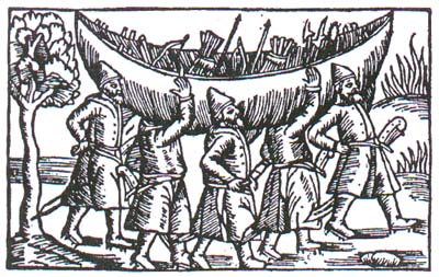
Prepared for the international conference in Lyngdal, Vest-Agder, Norway 29th Sept-3rd October, 2004.
The geographical scope of this conference has by degrees been concentrated to Europe, especially Northern Europe.
 Back to Nordic Underwater Archaeology