Excavating submerged Stone Age sites in Denmark – the Tybrind Vig example  

by Torben Malm

Abstract:

The first submerged settlement excavated in Denmark was the Tybrind Vig site. In the decade from 1977, this site was the scene of intensive excavation activity. 300 m from the shore and 3 m below the surface, divers excavated sensationally well-preserved artefacts from the Ertebølle Culture.

These finds, and the great amount of important information from the site, exemplify the special nature of well-preserved coastal settlements on the sea floor. The paper describes how high-quality excavation of such a site can be carried out at relatively low cost. It also stresses the urgency of undertaking such excavation, many hitherto well-preserved settlements on the sea floor being now subject to rapid erosion, probably due to pollution.
  

Find circumstances

Due to the dominance of eustatic diver Michael Tønning, photo by Ole Mallingrise in sea level since the last Ice Age, large parts of the Stone Age hunting grounds and coastlines in Denmark are now covered by the sea. This also applies to many of the coastal sites from the Late Mesolithic Ertebølle Culture. South of the "tilt-line" (Mertz 1924; Christensen this volume), these sites are found on the sea floor, at depths up to 5 m below present-day sea level.

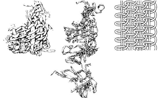
From museum archives we know that collection of Mesolithic settlement material had already taken place along the Danish coasts during the nineteenth century (Müller 1897, 18-23). Now and then special wind conditions and a strong ebb have made it possible to walk on parts of the sea floor that would normally be covered by a half to a whole metre of water. On these briefly exposed parts of the sea floor, antler, bone and flint artefacts have been collected, washed out of the submarine culture layers by the constant movement of the water.

The growth of towns in the last century was accompanied by many extensions and new constructions of harbours and fairways. In several cases rich finds were made. Implements were found, not only of flint, but also of bone and antler. These artefacts of organic material are preserved because they were deposited in undisturbed, chemically and biologically inactive gyttja sediments. These consist of reeds, leaves, branches and fine suspended material from the water.

The dredging of the channels was done with so-called bucket-ladder dredgers, i.e. large barge-like vessels that can scrape away the sea floor with brutal efficiency. It stands to reason that it was the larger and more easily recognizable items such as flint and antler axes, harpoons, bones and waste products in the form of large pieces of antler that attracted the attention of the operators, in the inferno of water, mud and noise on board these vessels. In fact it is remarkable that any artefacts at all have been collected under these circumstances.

After the Second World War, when it became more common to extract raw materials off shore, many large new finds were made (cf. Fischer 1987, 10-13). Sand and gravel was and still is sucked up in such a manner that the materials are already separated on board the vessel with the aid of a riddle. The desired fractions are collected in the hold, while the residue is simply dumped again. Now and again a crewman has been interested and acute enough to collect materials from the screen and hold. In this way large and relatively representative collections of artefacts, both in respect of material and types, have been made at different places.

Conditions of preservation

The colossal amounts of flint implements collected at Danish Stone Age settlements over the years reflect both the easy access there has always been here to this raw material and the considerable population of flint users who have lived here.

Most of the Mesolithic flint implements we now have in our storerooms derive from terrestrial deposits. But this does not mean that these assemblages are necessarily the most interesting. The sites have often been disturbed by cultivation, and artefacts of organic material are often all degraded by physical, chemical and biological processes. Under the sea, large amounts of artefacts from numerous settlements have been well protected – at least as long as they have been embedded in sediment. At several sites, the so-called refuse layers (organic gyttja deposit in shallow water outside the settlements) have ensured such favourable conditions that even wood, bast and bark are preserved.

That these soft gyttja layers, and for that matter also artefact-bearing sand and gravel deposits, are still preserved is due in particular to the eelgrass. Formerly, it grew along most of the inner Danish coasts, but today it is unfortunately nowhere near so widely found as before. Eelgrass has a tough rhizome which just below the sea floor grows out to form a strong network, which can hold the sand (Sand-Jensen et al. 1994, 27-40).

It should in this connection be remarked that Denmark, despite its good preservation conditions, is largely devoid of well-preserved submarine culture layers from the actual settlement surface, and that we are not particularly optimistic with respect to the future possibility of finding such undisturbed primary settlement surfaces. The fact is that these were already largely eroded in connection with the Atlantic and Sub-Boreal transgressions and regressions (fig. 1).

Fig. 1. Three stages in the transgression of a coastal Stone Age settlement (H. V. Jørgensen del.).
1) The area immediately above the shore is inhabited. Here are pits, fireplaces, etc. Large amounts of rubbish from the settlement end up in the reed beds off the settlement, in the so-called refuse layers. At the habitation area, waste is deposited from implement production, meals, and mislaid and destroyed tools.
2) The sea rises and floods the settlement. In the transgression phase, wave action erodes the culture layer on the habitation surface. The culture layer is washed out and the implements dispersed. Depending on location and topography, this dispersal could be more or less extensive, just as the deposition of sand can be more or less massive.
3) There is now so much water above the settlement that wave action no longer erodes the settlement deposits. A thin layer of sand is locally deposited, and eelgrass invades the area and holds the sand.

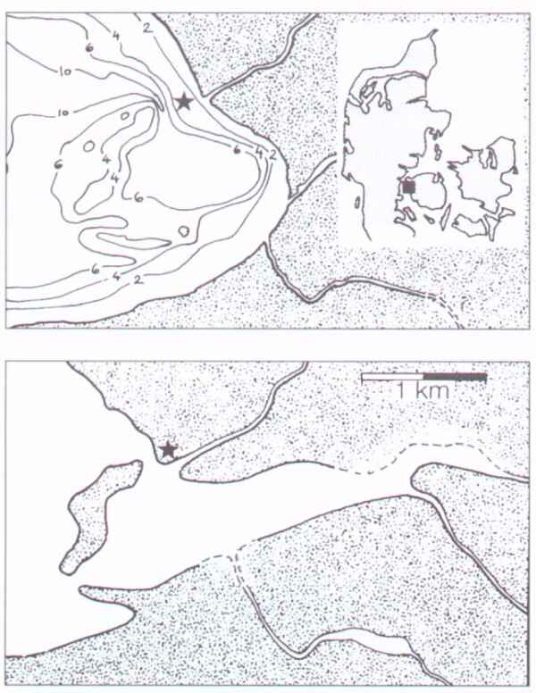
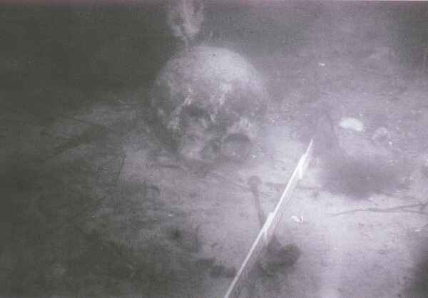
All our best and most interesting artefact finds have been recovered from the refuse layers outside the settlements. In the settlements themselves we naturally do find artefacts deriving from the habitation surface, but these are nearly always relatively robust flint objects that withstand being washed out and re-bedded, and most of which show signs of what they have been through.

If we should one day be so fortunate as to find an undisturbed settlement surface, it will probably be found that specific biological and topographical circumstances obtain. One could, for example, imagine a settlement on a relatively horizontal surface at a place where conditions are favourable to reed growth and which is well protected from erosion by the sea. At such a site, a settlement could in connection with a rapid transgression and subsequent overgrowth be preserved till the present day.

Cultural heritage management

The way in which the Danish sea territory is administered today allows the settlements to be protected, if not against the elements, at least against construction work. Stone Age settlements, barrages, wrecks of vessels older than 100 years, and the like, are protected by law (cf. Lund, this volume). In the National Forest and Nature Agency we check all projected construction work against the information we have in our databases, which contain all known Stone Age settlements, wrecks, etc., and against our models for the location of these phenomena (cf. Fischer 1993, and this volume; Fischer & Sørensen 1983, 111-119).

Exploring the Tybrind Vig settlement

The discovery

Investigation of the submarine Stone Age settlements started with the development of scuba diving equipment after the Second World War. But it was not until this became generally affordable in the early seventies that real progress was made.

Over the years, many non-professional scuba divers have made important discoveries on the sea floor, but especially a settlement area in the Tybrind Vig inlet, off the west coast of the island of Funen, attracts attention (fig. 2).

Fig. 2. Tybrind Vig. A) Present coastline, relief contours and watercourses. The settlement is marked with an asterisk. B) Reconstruction of the landscape at the time of settlement. The water level was 2.5-3 m lower than at present, and what is now an open inlet was then a protected cove, presumably with two openings to the Little Belt. The cove received at least two rivers, and the settlement was close to its northern opening, on a spit, just near a river mouth (H. V Jorgensen del.).

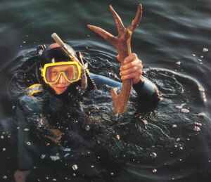
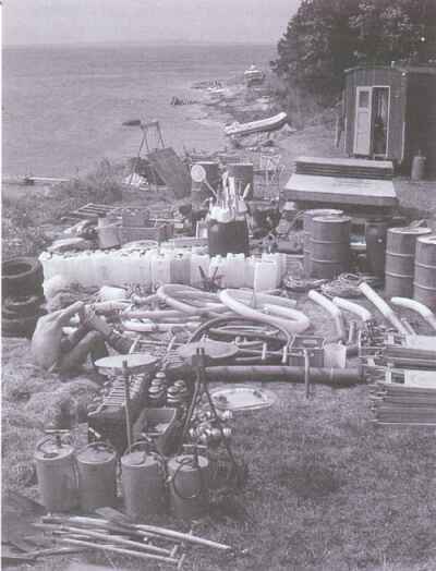
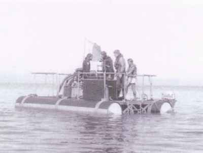
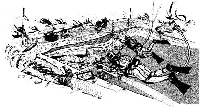
The locality was already known in the summer of 1957 when two amateur archaeologists and scuba divers Hans F. Larsen and Knud P. Rønne collected more than five hundred artefacts at a settlement about 500 m south of the one subsequently excavated (Albrectsen 1959).

One beautiful day in 1975, skindivers and amateur archaeologists from Fredericia were diving in Tybrind Vig. One of the divers, hunting fish, swam over an area with large amounts of wood and washed-out flint implements, which attracted his interest. Hans Dal could not know at that time that he had made his life's biggest catch. The group returned to the site during the following year and collected a very large and comprehensive material. In 1976 the divers, who had now formed the "Marine-archaeological Group", contacted Assistant Professor Søren H. Andersen, Århus University, for an evaluation of the material. This contact was the start of a fruitful and still ongoing collaboration.

The vast majority of the material proved to derive from the Ertebølle Culture, and attracted deserved attention, owing among other things to the uniquely well preserved artefacts of organic material. As both antiquarians and the divers of the Marine-archaeological Group were interested in further investigations, the first proper excavation at the site was arranged in 1978. This excavation was, actually, not the first true excavation of a Stone Age settlement in Danish marine territory. Langelands Museum had already been active in the sea south of Funen since the beginning of the seventies (Skaarup 1983 & 1993), but no excavations of the scale now projected had been undertaken. The Fredericia divers were both committed and energetic, and already during a three-week long campaign in the first year, over 20 divers made a large and interesting collection of artefacts.

Søren H. Andersen was general director of the project, while Danish archaeology students with diving experience had responsibility for day to day operations. The team was augmented every year with foreign students who for varying periods participated in work both on land and under water. Let it, however, be said from the outset that it was the divers who "bore" the excavation throughout – and always without remuneration. They undertook not only the actual excavation, but also applied for funding, provided the excavation material, compressors, boats, rafts and buts, organized the camp and took care of diving safety.

Funds were donated by Århus University, private firms, and by different public institutions.

The excavations ran each July from 1978 to 1988. That so many people could devote their entire summer holiday to this endeavour for ten years in succession is due entirely to the fact that the divers had their families with them and that a tent camp was established in the field adjacent to the excavation. I will not describe here the organization of the camp, but merely refer to figure 3. The picture shows how much equipment was involved in the submarine excavation in one of the years when we brought relatively little material with us, and all the divers' personal equipment is missing in the picture.

Fig. 3. Preparing underwater excavation at Tybrind Vig: some of the equipment collected on the field just opposite the settlement (T Malm photo).

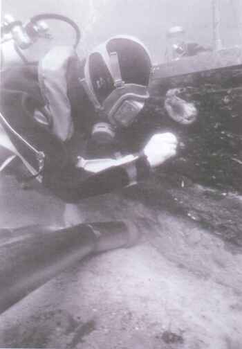
Planning and execution of submarine excavations

Before Tybrind Vig is further described, I shall offer some general remarks on the experience gained from ten years of excavation – "learning by doing".

First of all, one has to reckon with and live with, the fact that submarine excavation, in practically whatever way it is earned out, is an expensive undertaking. A price between five and ten times that for a corresponding cubic metre on land is not unusual.

Secondly, one should be prepared for difficulties in manning the excavation. Should one rely on volunteer divers and amateur archaeologists, who might not have so much archaeological routine, or on expensive marine archaeologists with the necessary competence and experience? This is not always a difficult decision, for experienced marine archaeologists do not – so far hang on trees. What should be given first priority, however, is commitment. Amazing results can be achieved when the right enthusiastic attitude is present.

Thirdly, submarine excavation requires very careful planning, if practical problems are to be avoided. If a single link in the chain of operations breaks and cannot be quickly repaired or replaced, all work comes to a standstill. The basic rule is that there should preferably be two pieces of everything.

Fourthly the excavation director has to learn to listen and take advice. It is the underwater work that has first priority. Methods, procedures and systems have to be organized so as to be most convenient for the divers, even if this implies that the data are presented in ways that are not the most ideal from the director's point of view.

A good question in the light of the above could be, why undertake submarine excavation at all, when so many problems are involved? The immediate answer is that it is possible to find artefacts in a state of preservation superior to those known from settlements on dry land (see below cf. Fischer this volume).

The excavations in Tybrind Vig

It was a motley crowd who attacked the gyttja layers in Tybrind Vig at the end of the seventies. We covered the whole spectrum from non-professional diver with no knowledge of archaeology and artefacts, let alone systematic excavation, to the assistant professor with thousands of hours of practical excavation experience on land but not one under water.

It was an exciting project, the inner dynamics of which led to a constant development in systems, methods and routines. With Søren H. Andersen's extensive experience, the excavation developed from year to year until it, in the last years, had reached a standard of documentation equivalent to similar excavations on land.

It would be rather disingenuous to maintain that these developments occurred smoothly and without conflict. But despite the often very different attitudes as to how we could achieve a high documentation level without losing ourselves in trifling detail and impractical routines, we could always give way to others' arguments, find a solution or agree on a compromise, and then join forces to get on with the job.

Up to 1978, the site had merely been subjected to surface reconnaissance, with collection of unbedded and washed-out objects. In 1978, so much information and confidence was acquired that a proper excavation could be undertaken, though in the first year primarily in the nature of sounding-trenches measuring 1 x 2 m.

As the settlement is situated more than three hundred metres from land, it was necessary to have a raft permanently moored at the site. For the first three years, the problem was solved with two small borrowed rafts from the nearest harbour, but since this did not prove to be a satisfactory solution, the divers made the raft illustrated in figure 4. Having once tried to work with such a large, stable diving-platform as a base, it becomes a "must". Our possibilities for continuing work despite deteriorating weather conditions were suddenly much better.

Fig. 4. The diving-raft in place at the settlement. Behind the raft the dinghy that transports the divers back and forth is glimpsed. Behind the divers is the water pump with the fire hoses that supply the underwater suction heads (T. Malm photo).

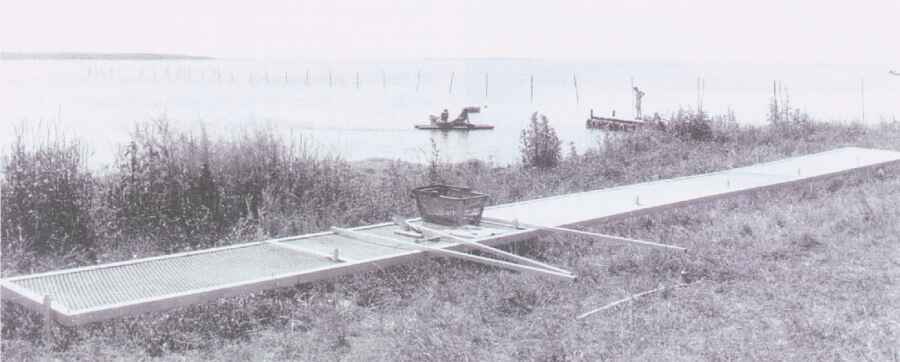
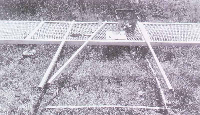
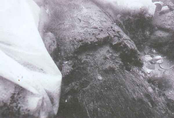
Over the years more than 50 m2 of varying nature of the site were excavated. In the central refuse part of this area, three-metre thick gyttja layers were present, while up on the eroded settlement surface, just five to ten metres north of it, only stones, gravel and washed-out artefacts were found directly on the moraine clay. Where the probes yielded good results, they were enlarged into bigger holes or longer trenches.

On the sea floor, the excavation areas were marked with large nails and ranging poles. Sections, which though several metres high stand firmly without support, were as far as possible kept vertical with a spirit level.

All finds were systematically three-dimensionally plotted, though it has to be admitted that accuracy during the first years was not quite up to that of equivalent terrestrial excavations.

Throughout, the motto was one man one square metre. Artefacts, stones and large branches were plotted with a rule within the square, and the level was taken, also with a rule, up to a spirit level held out horizontally from a point previously defined. Find information was noted on the labels placed with the finds. This excavation method was maintained until 1986, when the section rail shown in figure 5 was taken into commission.

The section rail

It is possible to excavate accurately only when there is a dimensionally stable reference frame. For this purpose a 10 m long and 80 cm wide section rail was manufactured in galvanized iron. The rail can be divided into three pieces and is furnished with feet that allow the whole thing, when it has been assembled on the sea floor, to be adjusted to horizontal, both longitudinally and transversally. The weight of the rail is itself so great that it does not need to be fixed (Malm 1987).

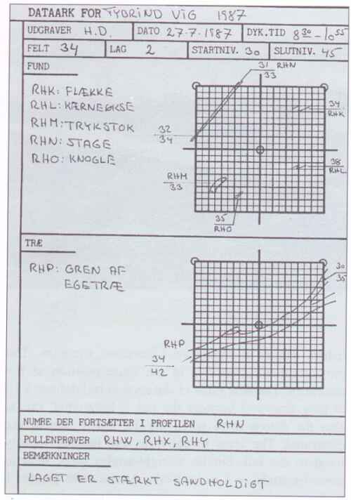
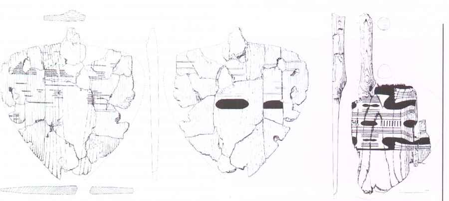
Fig. 5. The section rail lined up on land (B. Hansen photo).

As soon as the section rail has been established on the sea floor, ten successive metre-squares are established. Figure 6 shows an excavation situation. The photographer/viewer lies in the same position as the excavator. The near edge of the section rail defines a 10 m long line, and because the rail is horizontal, this is also the datum level when the 10 square metres are excavated. The arms to the right and left are loosely fixed to the rail, but lie at right-angles to it, held in place by studs, at 1 m intervals. As the arms project 1 m from the rail, one can with the aid of a plumb line accurately lay out a square metre. The arm in the middle is used when an excavated object is to be levelled. The arm is pushed over the object and the level taken with a rule from the object up to the underside of the arm. All information is documented on a waterproof documentation sheet (fig. 7).

Fig. 6. The section rail with measuring rods, plumb line, documentation sheets and excavation equipment (B. Hansen photo).

Fig. 7. Documentation sheet, here with an excavation plot. The sheet is in A4 format and on waterproof plastic "paper" (T Malm del.).

When the squares have been completely dug, the section is cleaned so it is vertical and even. On the small studs on the vertical fore-edge of the section rail, transparent metre-square acrylic sheets are hung on which the section is documented at 1:1 with wax pencils (fig. 8 and 9). These drawings are transferred on land to tracing paper and photographed.

Fig. 8. A marine archaeologist is recording the cleaned section on a transparent acrylic sheet. The section rail guides and holds the acrylic sheet. (PS. Philipsen photo).

Fig. 9. The section rail on the sea floor. Two divers are lying in an excavation segment where several square metres have already been excavated. With the section rail as starting-point and aid, the left diver is excavating the artefact bearing gyttja deposits in a square that has almost been dug out, while the diver on the right is recording the cleaned and straightened-up section on a transparent acrylic sheet with a wax pencil (T Thomasen del.).

The system with the section rail did not merely increase the section accuracy. To our surprise, excavation speed also increased. The system whereby the divers themselves earned out more extensive documentation also proved to give them a considerable degree of satisfaction.

A constantly recurring problem attending submarine excavation is visibility. The excavation brings so much material into suspension that after a while it is not possible to see anything clearly. This problem is solved with a kind of underwater vacuum cleaner. Fire pumps on the raft pump water – with a pressure of c. 6 atm. – down to a so-called suction head. In this a jet of water is reversed, so as to create suction. The head is manufactured from a stainless steel tube with a diameter of 10 cm. As in a vacuum cleaner, the sucked-up material is collected in a so-called discharge net. The amount of material collected in the net naturally depends on the mesh size, and on how finely grained the material being excavated is. In Tybrind Vig a mesh size of c. 6 x 6 mm was chosen.

When, as in Tybrind Vig, relatively coarse gyttja is being excavated, about 2/3 of the material will be retained in the net and only the smallest fractions be dispersed in the water. In this manner also the smallest finds are collected, such as fish-hooks, transverse arrowheads, charcoal and fish bones. In spite of the skilled excavators, only a limited amount of the small artefacts are found in the excavation phase. It is therefore important that the discharge nets are examined on land and that the material in each net comes from only one square and only one layer.

Securing stray finds

Over the years, Søren H. Andersen has written many articles – interim reports – both of a general nature and on selected find categories from the site. An overall publication of the finds from Tybrind Vig is now in preparation under his direction.

If one visits Moesgård it is not – compared with other Late Mesolithic settlements – the extensive artefact material that strikes one, but the state of preservation in which the objects are found, and the large percentage of finds of organic material, c. 60%.

The settlement was discovered because the sea had started an erosion of the preserved culture layers and washed-out artefacts. In the first years, many finds could thus be made directly on the sea floor. Such stray finds naturally do not yield so much information as carefully excavated finds, but for the Tybrind Vig site a different situation applies. The attention which the site attracted, and still attracts, has meant that both during excavation campaigns and outside them many hours were spent diving in the area. This has meant that freshly washed-out artefacts were often found and recorded before they lay ex situ. It is thus reasonable to accord these "stray" finds some importance. Some of the "fine finds" from the site are such "saved-in-the-nick-of-time" artefacts. A rough estimate from the first years gives a distribution of systematically excavated artefacts and stray finds of 50:50, changing to 80:20 during the last years (Andersen 1994 verbal communication).

Cultural remains from Tybrind Vig

Fishing equipment

The Tybrind Vig site contains all the generally known implements and types of the Ertebølle Culture. No other sites are, however, so well furnished with indications of exploitation of the marine element. The water was important as a line of communication, and the freshwater rivers, brackish inlets and coves, and saltwater sea were of great economic importance.

At first sight, it would perhaps seem unreasonable that the settlement was placed on a windswept point where there, most likely, was no direct access to fresh water. The reason was undoubtedly that the site had other advantages compensating for these drawbacks.

Stationary fish traps presumably existed off all coastal Ertebølle Culture settlements (cf. Andersen, Fischer this volume). It must have been practical to live in the neighbourhood of these traps when they were to be emptied. And as the fences must have represented a considerable investment in labour, it may also have been very important to be in the vicinity when the sea threatened to destroy the traps. Last but not least, an interest in having a title to ownership of the traps should be mentioned (Pedersen this volume).

In Tybrind Vig we have not found intact fish fences, but instead hundreds of up to 4 m long, straight hazel stakes lying horizontally in the rubbish layers: hazel stakes of a kind which from other finds we know were used in fish-fence constructions (Pedersen 1992). Furthermore, about ten pointed hazel stakes have been found driven down into the gyttja layers (Andersen 1987, 271). These were broken off 10 to 30 cm from the tip, but are undoubtedly also parts of fish fences. Wickerwork traps were also a part of such fish barriers, and remains of one have actually been found in Tybrind Vig (Andersen this volume).

In these fishing arrangements it must have been possible to obtain an important food resource, and in periods, for example when eels were migrating, there must have been a large surplus of food (cf. Pedersen this volume).

Two other kinds of fishing have been documented: angling (Andersen 1987b, 270-271) and spear fishing (Andersen 1985, 61-63 & 1987b, 271-273). Altogether, between 10 and 20 fish-hooks of red deer bone have been found, one of them actually with a piece of line attached.

Spear fishing is attested by a number of finely worked tines of hazel, both fragments and whole pieces. Unfortunately none of the tines has been found mounted as bound to the shaft. Only one such find is known from Denmark, from a settlement on the north-western tip of Ærø (Skaarup 1981, and this volume). On the other hand, about a hundred spear tines have been found in Tybrind Vig, of varying size and shape, presumably according to which fish was sought and on which bottom, soft or hard.

Another important find group representing fishing consists of fish bones. Numerous of these small bones from a large number of species have been found (Trope-Lassen 1984).

All this about fishing does not imply that hunting and gathering were not important economic activities, but there is good reason to suppose that fishing must have been the most important.

Previously it was a widely held view that everywhere in Denmark towards the end of the Mesolithic there was a settlement pattern whereby people moved between several sites in order to exploit different resources (Petersen 1973, 97; Andersen 1975, 88-89). It is now time to refine this picture. The heavy dependence on the aquatic environment, the short distance to the coast almost everywhere in Denmark, and the necessity of maintaining the rights to a good fishing site may mean that the Ertebølle Culture was far more coastally oriented and settled than previously believed.

Textiles

Among the remarkable finds from the settlement are some of Northern Europe's oldest textiles. The pieces found, most of which are seen on figure 10, are made of spun plant fibres in the so-called needle-netting technique (Andersen 1985, 68).

Fig. 10. Textiles from Tybrind Vig: Z-spun plant fibres knotted in needle-netting technique (O. Svendsen del., reprinted from Andersen 1985).

A grave with a young woman and a child

We know the settlement's inhabitants especially from a grave with a young woman and a child, but also from stray bones and bone fragments from at least two, possibly three, other persons (Andersen 1987b, 263). One of the skull fragments probably derives from a man and bears the marks of two healed lesions.

From Ertebølle Culture settlements at Vedbæk, Skatteholm, etc. (e.g. Albrethsen & Petersen 1977; Larsson 1988) we know that the dead were buried in a cemetery in the immediate vicinity of the settlement. We must presume that there is a connection between burials and settlements. A similar connection is presumed to apply to the Tybrind Vig grave (fig. 11). On the basis of a C14 dating (6440 b.p), it can be assigned to the earliest phase of the Ertebølle Culture. The woman is estimated to be 13-14 years old, and the child to be a baby up to three months old. No burial gifts were found, but the way in which the grave was found was a gift in itself: the water had gently "excavated" it, so carefully that even the child's bones were exposed but still in situ. Only the foot end of the grave and the right lower arm had suffered.

Fig. 11. As the Tybrind Vig grave with the young woman was found in 2.5 m of water near the settlement (H. Dal photo).

Dugouts and paddles

Some of Tybrind Vig's most marked find groups are the dugouts and paddles. Three dugouts, all of limewood, have been found: Tybrind boat no. I in 1979 (Andersen 1983, 162-172), Tybrind boat no. II in 1984 (Andersen 1987a, 87-106; Christensen 1990, 119-141) and Tybrind boat no. III in 1993 (Dal 1994). Boat I is 95% preserved to a length of 9.5 m, whereas boats II and III are preserved to a length of 3.2 and 5.2 m respectively.

Boat I is at one place in the stern preserved over its entire width, from rail to rail, although somewhat compressed. At this spot the original width is calculated to have been c. 50 cm.

In boat I and II, a so-called fireplace is preserved in the stern. A similar phenomenon has been observed in other Danish prehistoric dugouts. This "fireplace" is a lense of clay 60 x 35 cm and up to 3 cm thick, placed directly on the boat's floor. In the light of the fact that a dugout must have represented a considerable value and that an open fire on such a "fireplace" in a narrow dugout would have constituted an unnecessary hazard, I would suggest that the "fireplace" be renamed as an "ember place".

The boats were all found in what at the time of settlement was a belt of reeds outside the settlement. In this reed swamp, boat I at least was deliberately submerged and held down with a large stone.

Throughout the years of excavation, finds have regularly been made of both whole and fragmented paddles – between 10 and 15 specimens. They are all made of ash, with a shaft over 1 m long and a heart-shaped blade, around 30 cm in width.

Fig. 12. Two of the four ornamented paddles from Tybrind Vig. One is ornamented on both sides, the other only on one side (F Bau and O. Svendsen del., reprinted from Andersen 1987a). 1:5.

Four of the blades are remarkable in being decorated. In figure 12 two of the four ornamented paddles are shown (Andersen 1984, 11-30 & 1987a, 100-106). These paddles represent the first ornamented wood from the Danish Mesolithic and reveal – with their form idiom – aspects of the culture which we have not previously known.

Submarine settlements in future perspective

The large number of valuable finds made in Tybrind Vig could well lead one to believe that this settlement was and is quite unique, but this is not the case. If one examines the various find reports in the archives of the National Forest and Nature Agency, one often encounters reports on localities which either contained or still contain very interesting finds and information. On account of limited resources, it is, however, only a small number of these sites that have been inspected, let alone properly investigated.

Despite the increasing attention given to our submarine settlements during the last twenty years, it is paradoxically enough a very sad fact that many of these sites are in danger of being completely washed away and destroyed. The eelgrass which over the centuries has preserved the culture layers is currently retreating fast. For unknown reasons, eelgrass does not flourish as well as it used to do. Whether this is due to disease or pollution is a moot point. In the early thirties, an "eelgrass disease" that exterminated large areas of eelgrass along the Danish coasts flourished. At the time it was considered to be due to a fungus. The eelgrass returned, but never to its previous extent and strength. Today, there is a tendency to believe that it is pollution that creates an unfavourable environment for the eelgrass, although there is no certainty about this (Sand-Jensen et al. 1994, 38).

It would be technically possible to do something to preserve some of the best and most threatened settlements. In Tybrind Vig, the National Forest and Nature Agency established in 1990 an experimental securement of a low section (6 m long and 200 cm high), two visible and almost completely exposed tree trunks, and two surfaces (2.4 x 3.0 m and 4.5 x 5 m).

Such protection is performed by first rolling out a geotextile mat, of Fibertex for example, directly on the sea floor/object. In the establishment phase the mat is rolled up on iron pipe. After five minutes under water, the roll absorbs so much water that it sinks to the bottom. Here it is rolled out on the sea floor, which should preferably be fairly even. At the same time, several well filled sandbags are placed on the mat at intervals of max. 20 cm. Sandbags are also placed close to structures, for instance by the sections and the trunks at Tybrind Vig. This system with Fibertex and sandbags is so simple that archaeologists, with the aid of rubber dinghies, can carry it out themselves directly from the shore.

On an inspection of Tybrind Vig four years after protection it could be ascertained that the sandbags around the section and the tree trunks had been overturned and moved about, but that the Fibertex around the trunks was nevertheless still in place (fig. 13). In contrast, on the surfaces, the protection was completely intact. Between the sandbags, sand and gravel had been deposited, and seaweed and eelgrass had begun to re-establish themselves (fig. 14).

Fig. 13. One of the "Fibertex-secured" tree trunks from Tybrind Vig. The top third of the trunk, the grey part, has been covered with Fibertex, while the bottom lay exposed. The Fibertex has been cut and turned aside to permit photography. The picture shows clearly what happens when shipworms have unrestricted access to wood. The extensive destruction of the surface of the trunk has occurred in the course of four years (T Malm photo).

Fig. 14. The largest of the secured surfaces in Tybrind Vig. Between the sandbags, sand and gravel have been deposited (T Malm photo).

It must be pointed out that our experience of these measures is confined to Tybrind Vig, which although fairly exposed, does have a depth of c. 2.5 m, implying that wave erosion is not so strong as it would be in shallower water. We are aware that commercial enterprises are able to secure the sea floor completely, but the cost is up to ten times that of the system with Fibertex and sandbags.

Unfortunately, we have to face the fact that despite the low cost of the system we have tried at Tybrind Vig, the expense of protecting merely the most severely threatened of the most informative settlements will greatly exceed the resources likely to be at the disposal of the antiquarian world during the near future.

As total excavation cannot be carried out either, we will in the years to come probably have to live with the absurd situation that our knowledge – due to the finds brought in – will increase considerably, while we are witnesses to the destruction of a unique source in the form of numerous settlement deposits.


Torben Malm

Kulturarvstyrelsen
Slotsholmsgade 1
DK-1216 København K

Acknowledgements

I would like to express my cardinal thanks to all the divers who over the years did a tremendous piece of work in Tybrind Vig, and to the divers' families who created an incredibly hearty social atmosphere in the camp.

The Tybrind Vig decade was instructive for all of us, not least because of the extensive collaboration between the various parties involved. I would like to take this opportunity to thank my fellow field supervisors, Jørgen Dencker and Per Smed Philipsen, for inspirational cooperation.

Special thanks are due to Anders Fischer, Søren H. Andersen and Hans Dal for critical participation in the preparation of this paper, and to Peter Crabb who did the translation of this manuscript.

References

ALBRECTSEN, E. 1959, Flinteflækker og frømænd. Fynske Minder. Odense.

ALBRETHSEN, S.E. & E. BRINCH PETERSEN 1977, Excavation of a Mesolithic Cemetery at Vedbæk, Denmark. Acta Archaeologica  47. Kobenhavn.

ANDERSEN, K. 1985, Frihavnen - den første Kongemoseboplads. Nationalmuseets Arbejdsmark 1985. København.

ANDERSEN, S.H. 1975, Ringkloster. En jysk indlandsboplads med Ertebøllekultur.  Kuml 1973-74.

ANDERSEN, S.H. 1980, Tybrind Vig. Foreløbig meddelelse om en undersøisk stenalderboplads ved Lillebælt. Antikvariske Studier 4. Fredningsstyrelsen. København.

ANDERSEN, S.H. 1983, En stenalderbåd fra Tybrind Vig. Antikvariske Studier 6. Fredningsstyrelsen. København.

ANDERSEN, S.H. 1984, Mønstrede Åreblade fra Tybrind Vig. Kuml 1982-83.

ANDERSEN, S.H. 1985, Tybrind Vig. A preliminary Report on a Submerged Ertebolle Settlement on the West Coast of Fyn. Journal of Danish Archaeology 4. Odense University Press.

ANDERSEN, S.H. 1987, Mesolithic dug-outs and paddles from Tybrind Vig, Denmark. Acta Archaeologica 57. København.

ANDERSEN, S.H. 1987, Tybrind Vig: A Submerged Ertebolle Settlement in Denmark. In Coles, J.M. & J.L. Lawson (eds.) European Wetlands in Prehistory. Oxford.

ANDERSEN, S.H. & C. MALMROS 1985, Madskorpe på Ertebøllekar fra Tybrind Vig. Aarbøger for nordisk Oldkynclighed og Historie 1984. København.

CHRISTENSEN, C. 1990, Stone Age Dug-out Boats in Denmark: Occurrence, Age, Form and Reconstruction. In Robinson, D.E. (ed.) Symposia of the Association for Environmental Archaeology 9, Oxbow Books.

CHRISTENSEN, C. 1993, Land and sea. In Hvass, S. & B. Storgaard (eds.) Digging into the past. 25 years of archaeology in Denmark. Århus.

DAL, H. 1992, Ronæs Skov. En submarin Ertebølleboplads, Gamborg Fjord, Vestfyn. Marine-Arkæologisk-Gruppe. Rapport udarbejdet i samarbejde med Forhistorisk Arkæologisk Institut, Moesgård. Århus.

DAL, H. 1994, Udgravningsberetning, Stammebåd III i Tybrind Vig. Marine-Arkæologisk-Gruppe. Rapport udarbejdet i samarbejde med Forhistorisk Arkæologisk Institut, Moesgård. Århus.

FISCHER, A. 1987, Stenalderbopladsen på Argusgrunden - En 7000-årig bebyggelse på bunden of Smålandsfarvandet. Fortidsminder og kulturhistorie. Antikvariske Studier 8. Skov og Naturstyrelsen. København.

FISCHER, A. 1993, Stenalderbopladser i Smålandsfarvandet. Skov- og Naturstyrelsen. København.

FISCHER, A. & S.A. SORENSEN 1983, Stenalder på den danske havbund.  Fortidsminder og Bygningsbevaring. Antikvariske Studier 6. Fredningsstyrelsen. København.

HOUMARK-NIELSEN, M. 1989, Danmark i istiden. VARV 1989 (2). København.

IVERSEN, J. 1967, Naturens udvikling siden sidste istid. Danmarks Natur 1, Landskabernes opståen. Politikens Forlag. København.

MALM, T. 1987, L7, Profilskinne og H4, Udgravningsskema til submarine bopladser. Arkæologisk Felthåndbog. København.

MERTZ, E.L. 1924, Oversigt over de sen- og postglaciale Niveauforandringer i Danmark. DGU II Rk.,41. København.

MÜLLER, S. 1897, Vor Oldtid. København.

PEDERSEN, L. 1992, Ålegård. SKALK 1992 (6). Højbjerg.

PETERSEN, E. B. 1973, A Survey of the Late Palaeolithic and the Mesolithic of Denmark. In Kozlowski, S.K. (ed.) The Mesolithic in Europe. Warszawa.

PETERSEN, K. S. 1985, The Late Quaternary History of Denmark. Journal of Danish Archaeology 4. København.

RIECK, F. 1988, Både fra Danmarks oldtid. Vikingeskibshallen, Roskilde.

SAND-JENSEN, K., J. BORUM & C. DUARTE 1994, Havgræsserne i verdenshavene. Naturens Verden 1994(1).

SKAARUP, J. 1881 Lyster. SKALK 1981(6), 10-11. Højbjerg.

SKAARUP, J. 1983, Submarine stenalderbopladser i Det sydfynske Øhav (English summary). Antikvariske Studier 6. Fredningsstyrelsen. Copenhagen.

SKAARUP, J. 1993, Submerged settlements. Digging into the past. 25 years of archaeology in Denmark. Århus.

TROLLE-LASSEN, T. 1984, A preliminary report on the archaeological and zoological evidence of fish exploitation from a submerged site in Mesolithic Denmark. C.N.R.S. Centre de Recherches Archéologiques. Notes et Monographies Technigues 16, 133-143.

AARIS-SØRENSEN, K. 1988, Danmarks forhistoriske Dyreverden. Fra istid til Vikingetid. København.


The author is presently employed by Kulturarvstyrelsen (The National Cultural Heritage Agency).

The article was originally published in Anders Fischer (ed): Man and Sea in the Mesolithic. Oxbow Books, Oxford 1995.
Colour photo by Ole Malling, courtesy Anders Fischer. Article published with kind permission on Nordic Underwater Archaeology Jan '03, revised jul '12.


To Main Page 
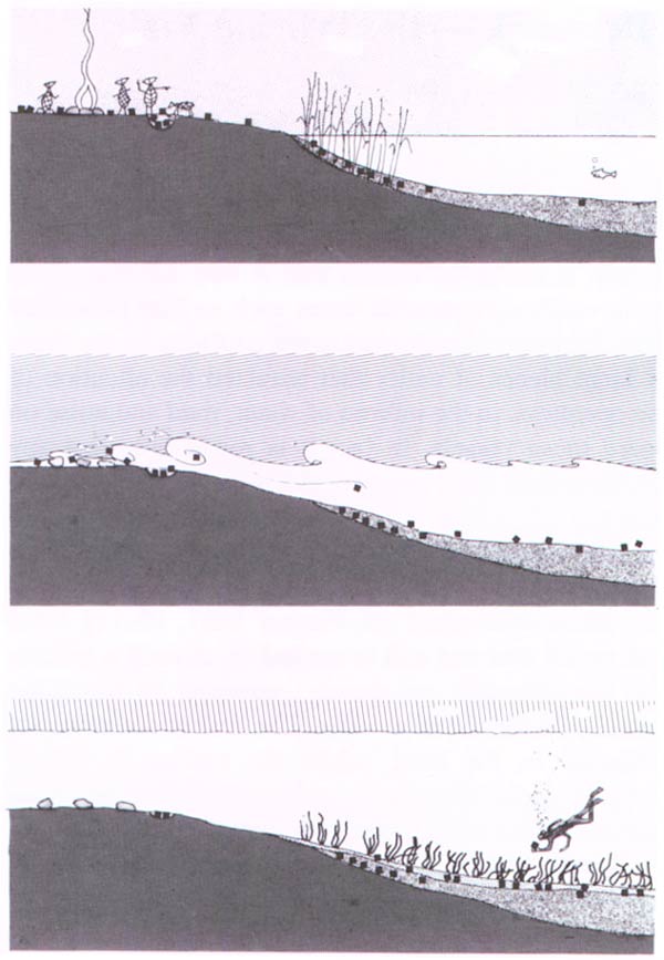
Back to Nordic Underwater Archaeology