Russian or Swedish Marine Fortifications on the Bottom of the Bay of Tallinnby Vello Mäss
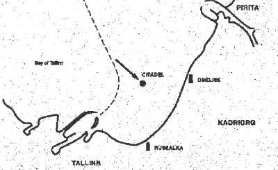
A huge mound of stones and timber with an approximate area of 3500 m2 was found on the bottom of the Bay of Tallinn by the amateur marine archaeologists of the Estonian Maritime Museum in 1985 (Fig. 1). Judging by the state of preservation of this stone and wooden construction, lying between the depths of 8 to 11.5 metres and 900 metres offshore, the newly discovered object could be dated to the 18th century, but its purpose and origin remain uncertain. Ends of the thick logs were fastened to each other using tenons in some places, but the whole construction seemed to be badly damaged, parts completely destroyed. In close vicinity the ruins, three strong and massive log-frames, filled with stones, were found.
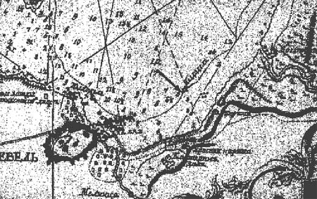
Fig. 1. Location of the newly found object within the Bay of Tallinn. On the map of the Bay of Tallinn, made by the Russian hydrographer Aleksei Nagayev in 1757, a small angular object with the description Citadel in the Russian language can be seen at the location of the underwater construction (Fig. 2). According to historical sources, the marine fortification Citadel had been erected there in the 1720`s. The fortification was intended to keep the fairway leading to the Tallinn harbour under the control of the cannons placed on the Citadel.
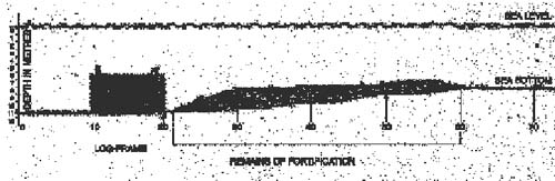
Fig. 2. Map of the Bay of Tallinn by Akelsei Nagayev from 1757. In 1997-1998, the Maritime Museum continued more detailed investigation of the remains. The depths around and above the fortification were measured and some videotapes made. The very strong and solid construction of the log-frames suggest that they had been placed at the seaward side of the fortification in order to protect the Citadel against possible attacks by enemy warships, heavy sea and drifting ice. Construction of the "protective line" was obviously not completed. On top of each log-frame another similarly con-structed box should have been placed. In November 1998, the surveying vessel "Jacob Hägg" of the Swedish Maritime Administration arrived in Tallinn. With the help of Bert Westenberg, from the Swedish National Maritime Museum in Stockholm, it became possible to use the ship and its modern technology to discover the exact plan of the fortification (using side scan sonar) and obtain an impressive overview of the whole 3,500 m2 area. The results of the survey enabled researchers to draw the side view of the remains and determine the extent of its current damage (Fig.5). It can be seen that only a relatively small part of the Citadel still exists. A great deal of the stones and timber are missing. Has the Citadel been destroyed by the sea or drift-ice? Evidently not because no building material can be seen scattered on the bottom in the vicinity of the remains. The most probable explanation is that when the harbour of Tallinn was restructured and extended in the 19th century, the old-fashioned Citadel was dismantled and used as a store of building material.
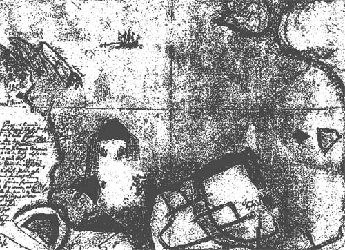
Fig 5. Side view of the fortification. Curiously enough, a 17th century Swedish free-hand drawing of the harbour of Tallinn, with the indication of the Citadel at the right edge was found in the town archives of Tallinn (Fig. 6). The tree-ring dating method was used to determine the age of the Citadel but no satisfactory result was obtained. It is known that during the period from 1713 to 1715 a huge amount of building material – 90 000 logs and at least 1000 cubic fathoms of stones – was ordered to be transported to Tallinn for building the naval harbour by Tzar Peter the Great. Timber was cut down and transported to Tallinn from all over the Estonian and Livonian territory – from the districts of Riga , Cesis, Pärnu , Tartu and the surrounding areas of Tallinn. Thus the question of when and who started building the Citadel remains unanswered.
Fig. 6. 17th century Swedish free-hand drawing of the harbour of Tallinn and the fortification with the Citadel on the right edge of the drawing, marked with an arrow. by Vello Mäss
This presentation is a summary of one part of a research project under way at the Södertörns Högskola by the author. It will be presented under the title Marinarkeologin i forskning och forskning. En studie av den svenska utvecklingen. (Engl.: “Marine archaeology in Science and Society. A study of the Swedish development”. This text published in print in The Marine Archaeology of the Baltic Sea Area, vol 3, 2000. Published on Nordic Underwater Archaeology Oct '00 |
 Back to Nordic Underwater Archaeology