|
During four years an underwater archaeological research team has submerged in a dangerous sector of the South Atlantic Sea exploring the shipwrecks remains. The research field is La Isla de Lobos (wolf’s island), a granite rock in front of the Punta del Este coast in Uruguay. For almost 400 years, the ships have sunk due to the sudden southwest wind, locally named Pampero and frequent fog bank (Nasti 1999). The great quantity of shipwreck remains, the sharp rocks and the submarine current becomes very dangerous for diving. Therefore, we were able to acquire a ROV to explore the sea floor. The purpose of this paper is to present the technology in action to the underwater archaeology research. In pursuing this goal we will develop a scientific resume of the activities and final results. This study emphasizes the use of marine technology to built archaeological testable models, which will, in turn, be compared and contrasted with the archaeological record. Depending on the technology available, the areas between wrecks may have functioned as important resource exploitation zones, or alternatively could have been perceived as empty spaces to be crossed as quickly as possible. For example, an investigation team with marine technology would likely have exploited any potential wreck zone available while navigating from one space to another. Underwater archaeology in South America has so far not used much ROV technology. However my analysis shows that marine technology in underwater archaeology is a discrete and complementary research resource. Most shipwreck archaeology studies, especially those in South America, have focused on another thing, the recovery of the historical items and useful cargo. The Isla de Lobos survey, on the other hand, has focused more on analysing methodological technicals, specifically on determining spatio-temporal differences between the shipwrecks on island environments conditioned by weather fluctuations in navigational conditions.
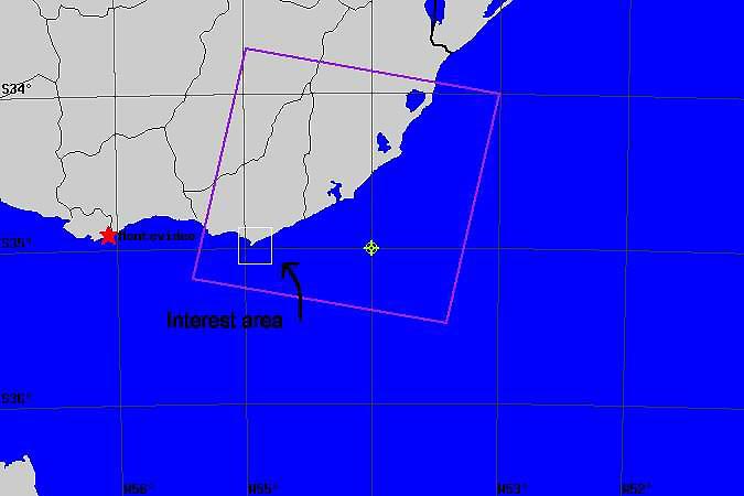
Fig 1: Isla de Lobos area, Uruguay Area of surveyIsla de Lobos in the side northeast of Punta del Este City in Uruguay (Figure 1), was chosen as a case study because it offers the outer edge, a peripheral area, of the north of River Plate basin, as well as small data universe. As the outer edge of Bahia de Maldonado it offers the advantage of what appears to be a relatively undisturbed data set in archaeological terms.
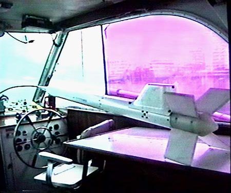
Fig 2: Magnetometer fish MetodologyIn order to better measure the interaction occurring between the different shipwrecks, I apply a conceptual framework of shifting scales of observation and analysis. In first time to detect ferrous remains, we used a high resolution magnetometer Geometrics G-800 (marine cesium) with sensitivity 0.002 nT at samples per second selectable (Figure 2). This instrument allows us with a special hydrographical software, Turbo Sodena 2000, to calculate the ferrous volume according to detected value, in such a case to 10 a 56 metric ton. In order to identify the principals geographical coordinate point detected, we used on board an DGPS (Differential Geographic Positioning System) model Valsat Station 2008 M2. For the second stage of the investigation, the exploration with the use of the ROV, we send an Deep Ocean “Phantom” P-300. This ROV works at 100 meters depth with 2 horizontal thrustera and 1 vertical thruster.
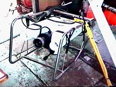
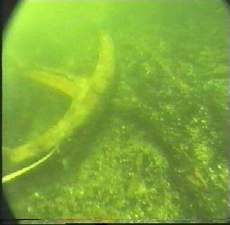
Fig 3: ROV The ROV has replaced scuba diving in most occasions and has developed to one of the principal tools of research (Arnold 1981; Tarlton 1983). The ROV has a digital video camera model Simrad OE 1367 Colour Autofocus 12:1 zoom (Figure 3). The image is captured in a computer and may be analysed carefully to help us to record the archaeological remains, built the archaeological context and contribute to a better scientific investigation (Figure 4). The use of this complementary method, provides us with particular data that may be de-emphasized at a different scale of observation. In future research this methodology will result in more comprehensive evaluations of shipwreck patterns.
Fig 4: ROV image The ROV technology and the DGPS will contribute to studies on closely juxtaposed shipwreck remains, and is presented here as means for overcoming the perceived inadequacies of the existing explanatory models for Isla de Lobos underwater archaeology. ConclusionThe ROV technology approach views each shipwreck from a regional perspective. The goal is to elucidate the dynamic relationship effected by the historic ship occupying the region under study. Isla de Lobos offers a relevant case study because the underwater archaeological record is significant by redundant shipwrecks. It offers an example of continuously occupied area with a non-clearly definable stratigraphic sequence because this geographical location was used as regional connections. Developments within the fields surveying and deep water surveillance have made available a range of equipment which, in many circumstances, can allow more effective archaeological investigation of the seabed. Remote sensing equipment can often be deployed in sea conditions worse than those in which divers can operate safely. Their greatest advantage, however, lies in the ability of the instrument to collect large amounts of information quickly and at some distances from the source. This allows search patterns to be much more widely spaced and at a greater over the ground speed than could ever be achieved by divers. The use of ROV can perform many of the tasks of a diver, including visual searches and photography. But is very important to explain that all the technology to serve marine archaeology can’t replace all detection and search methodology but is more and more complementary. by Atilio Nasti Scientific Director of Isla de Lobos Underwater
Archaeological Project Arnold III. 1981 Remote sensing in underwater archaeology. International Journal of Nautical Archaeology 10:51-62. Nasti, A. 1999. Proyecto de Rescate del navíoGanges. Isla de Lobos. Punta del Este, Uruguay. (manuscrito) Tarlton, K. 1983 Electronic Navigation and Search techniques. In Jeffrey W. And Amess J (eds), Proceedings of the Second Southern Hemisphere Conference on Maritime Archaeology. |
 Back to Nordic Underwater Archaeology