by Pere IZQUIERDO I TUGAS & Josep Maria
SOLIAS i ARIS
Lion head crowning smooth bronze helmet.
|
Under Franco's regime, a great number of Catalan archaeological sites were partially or totally spoliated and/or destroyed, the public powers being absolutely unconcerned about this fact. A paradigmatic example of this situation is the Les Sorres anchorage, a vast site a few kilometres south of Barcelona, under the river Llobregat delta. Although the destruction of this site was initiated in 1960, it was not until the 1980s that the scientific studies, not yet finished, were started (Tarradell, 1977 and 1983; Solias, 1982 and 1989; Izquierdo, 1985, 1986, 1987, 1988 and 1989). We are grateful to Mr Xavier Menéndez Pablo, of the Museums Technical Division of the Barcelona Council, for his information about the recent illegal exportation out of Spain of a de luxe bronze helmet coming from this site. This piece of information made it possible to find a second helmet in March 1990. We intend to present both pieces and their archaeological context, despite the study not being finished yet, so as to announce the discovery, and hope to complete this information in subsequent issues. The Llobregat deltaThe Llobregat valley is a narrow corridor, which allows the easy crossing of the barrier imposed by the Catalan Littoral Mountain Range. It is because of this characteristic that it was used as way through towards inland Catalonia. The river allows direct access to the Vallès-Penedès hollow, which represents a union axis between the NE and the SW of Catalonia, at the same time that it leads to the Pyrenees and inland Catalonia, thus being a major communication way. That is why this territory was profusely inhabited in the old ages and also why many ships coming from other Mediterranean areas visited the region coastline. It is very difficult to correctly determine the extension and boundaries of the Llobregat coastline in the old historical period. The presence, under the Llobregat delta, of sunk ships remains and their load, makes us think that the area nowadays occupied by the deltaic plain was used as anchorage area, at least from the 4th century BC to the Lower Roman Empire. What do we mean by delta? It is a tridimensional body, partly in the open air and partly submerged, which has formed in the mouth of a river when this carries too large an amount of sediments to be removed by the erosion processes of the receiving basin, thus appearing dynamic balance situations which may change with time (Marquès, 1985:152). The Llobregat delta has the shape of a wedge, which has its minimum powers in the inside edges and its maximum powers in the outside edge. At the Remolar lake it has been determined that the delta lands are over 150 metres deep (Marquès, 1984: 143). Inside this wedge, two clear stratigraphical packets have been separated which seem to roughly correspond to those found in other deltas in the Mediterranean. The lower level has been called lower dentritic complex, while the upper level has been called deltaic complex. The lower dentritic complex is situated on a Paleosoil, which presents a marked topographical irregularity: its surface has got two big hollows or valleys and a third one a bit smaller. The central basin would correspond to the continuation on a straight line of the Llobregat valley towards the area of the two lakes L'Illa and La Ricarda. It is 116 metres deep in its lowest point (Marquès, 1984: 145) It is thought to be an old buried deltaic structure and we have a radiocarbon dating of its roof taken from a sample extracted at -53 metres which gave out a dating of 10.900 ± 140 BP. The upper packet, known as deltaic complex, comprises the materials from this level of sea stabilisation to the present surface levels of the deltaic plain (Marquès, 1984: 159 and following pages). A stabilisation of the sea level at -20 metres can be seen, from which a new transgressive stage is developed, followed by the progradation which causes the emergence of the deltaic plain (Marquès, 1984: 175). Marquès (1984, 176-181) situates the recognisable coastal front line along the old València road, on a strip 200 metres wide, and proposes to date this coastal bar in the 1st century of our age, basing his theory on the Roman materials found in the arid lands exploitations. Nowadays this chronological interpretation is questioned, thus we have already mentioned the need to review the dating of this shore (Izquierdo, 1985; Solias, 1989: 71 and following pages). Apart from this front line it seems that others can also be seen (Marquès, 1984):
A typical evolution pattern might be as follows: after a bar was formed, others formed progressively in front of the first one, which remained as high areas, leaving marshes between them. With time, those marshes would get filled up with sediments. This must have been a continuous process and it is also possible that different bars were forming at the same time (Marquès, 1985). The reasons for the delta growth could be (Marquès, 1985: 164) deforestation of the Llobregat upper basin and the introduction of surface erosion favouring farming techniques. Cereals, for example, leave land completely bare for part of the year; vineyards, olive trees and fruit trees leave it partially bare the whole year. As far as the present evolution of the delta coast is concerned, the following things can be observed (Marquès, 1984: 188-190):
The regression of the delta is found especially in the most prominent part of it, probably due to the following causes:
The redistribution of the materials along the delta shore, from the most prominent areas to the most sunken ones, must be, in short, the cause that in the Castelldefels area the beach is still advancing. This process will progressively weaken until a new balance line is found, probably much more inland than at present. As one can see, the current steadiness problems of the delta have their origin in the excessive and irrational exploitation of the land.
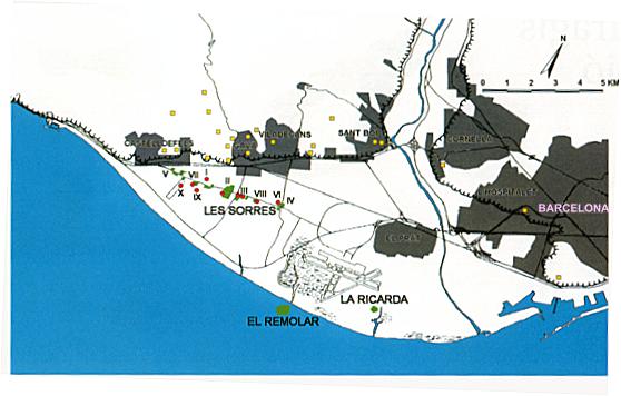
Location of the Les Sorres anchorage and the Les Sorres VIII wreck. The "Les Sorres" anchorageThe Les Sorres site is proof of the existence of an old huge anchorage area, situated on the south-west bank of the Llobregat mouth, in a roadstead protected from the north quadrants winds by the last spurs of the Garraf Massif. According to the findings there, this anchorage area must have been used in the antiquity as a trade harbour for the Llobregat valley, placing itself west of the valley in order to prevent the winds in it to threaten the ships steadiness. However, the roadstead must have been open to the east winds, which can account for the sinking of some of the eight wrecks found there. That the area was frequently used for anchorage purposes is widely proved by the great number of anchors found, of which we have been able to document nine made of iron, as well as two stocks and a lead clasp. A lot more materials have been found, which are disperse from the point of view of both time and space, coming from the cleaning of the ships draughts and the accidents that most probably took place during the loading and unloading of the ships with the help of auxiliary boats. At present the site is situated under the river Llobregat deltaic plain, around the old royal road from Barcelona to València in the municipal districts of Castelldefels, Gavà and Viladecans. The extractions of arid lands have made it possible to prove that the site extends discontinuously along about six kilometres and it is about eight hundred metres wide, at the most, on each side of the above mentioned road, although this area could be even bigger. The findings lay at a depth of some five to fourteen metres under the deltaic plain, which means a depth of three to twelve metres under sea level. These data conform to the usual margins for ancient anchorages (Gianfrotta & Pomey, 1981). According to the materials that we know, most of which are at the moment in the Gavà Museum, the anchorage was first used during the Old Iberian period, around the fourth century BC, as indicated by the Ebusitan Punic amphorae with shapes 14 (350±45 BC) and 22 (300-250 BC) according to Joan Ramon, and a black glaze bowl from the Roses workshop, which can be attributed to the Lamboglia 25 type (300-250 BC). The period of maximum activity can be situated during the 2nd and 1st centuries BC and the first half of the 1st century AD. During this period two clear cut stages follow each other: until the last quarter of the 1st century BC, it seems that the anchorage saw the massive arrival of Italic wine coming from Campania, Latium and Apulia destinated probably to the native and the first Roman inhabitants' consumption. In the second half of the 1st century BC, the romanization of the region brought about the rapid growth of the vineyard cultivation, and thus the Llobregat valley became an export area for low quality wines which were sent first to the south of Gaul and later to the big market in the city of Rome. Because of not yet quite clear reasons, it seems that the exportation of wine stopped about the middle of the century, and the passage of gallic amphorae of unknown destination through can be detected. Baetic oil containers as well as fish sauces have also been found. The materials found prove that the anchorage was used until the 5th century: African amphorae belonging to different types and times have been found (Izquierdo, 1985, 1986, 1987, 1988, 1989). Apart from materials related to the wine trade, other objects related to the metal trade, especially iron ingots and iron ore as well as lead ingots and tubes have also been found in the anchorage. The Les Sorres VIII wreckThe Les Sorres VIII sector wreck was located by chance in the middle of the 60s, during an extraction of arid lands in the municipal district of Gavà, and the discovery was kept secret. In order to avoid trouble with the public authorities, most of the wreck was left in situ and covered with rubble, and most of the objects found were destroyed. According to oral witnesses, a wooden ship bodywork was found, the hull of which was coated with lead planks. The wreck was of considerable size and there were a great deal amphorae, all of them globular shaped and with a neck and two handles, which make us think that they most probably were Greco-Italic amphorae. Very few objects were kept: a bronze helmet, recently sold to the Christie's gallery, was picked up by the driver of the machine carrying out the extraction; another helmet, which is now kept in the Gavà Museum, was used at the beginning as decorative object in the facilities of the extracting company; one of the three iron anchors found was given to a well-off family to decorate their country house; some amphorae were picked up by the lorry drivers scattering the sand and will not probably be located. Several witnesses state that there were lead tubes made from a sheet, probably part of a drain pump, while others have also told us about a sword, a datum that sounds a bit more doubtful and that we have not been able to confirm. Finally, an archaeology amateur picked up a bronze bell, which has been in the Gavà Museum since 1978. The wreck is situated between two sectors clearly used for anchorage in the past, in an area where the finding of ancient objects was relatively scarce. A few hundred metres to the east a ship with a load of iron ore has been located (Les Sorres IV) and an anchorage area probably related to the Roman villa of La Mare de Déu de Sales (Viladecans). One kilometre to the west there is the sector called Les Sorres III, where two more wrecks were located, one of which can probably be dated to correspond to the third quarter of the 1st century BC (Les Sorres IIIb), while the other one carried a load of "dolia", local amphorae with the shape Dressel 2/4, a worked marble block which was destroyed, and some big diameter lead tubes and ingots. The dating of this wreck corresponds to the first half of the 1st century (Izquierdo, 1987). The materialsThe objects coming from the Les Sorres VIII wreck that we have been able to index up to now are the following ones:
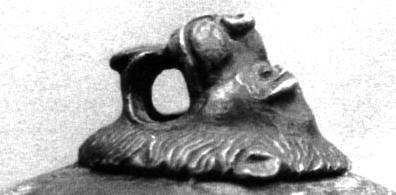
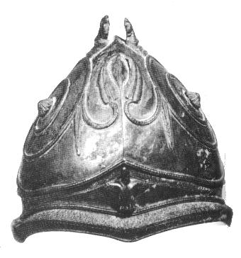
Bronze helmet sold in London in 1989, coming from Les Sorres VIII (Drawing by M. Carbonell). 1. Bronze helmet decorated with appliqués of the same metal. We know it only through photographs and photocopies from which a drawing has been done. The helmet is ultrahemispherical, slightly pointed along the longitudinal axis. The decoration is symmetrical on both sides of the axis and is composed of the following motives: on the lower part, forming a continuous visor, there is a scales double line. On top of it, in the middle of the front part, there is an appliqué of a piece that represents a winged human figure torso, probably a chimera. Above it, and taking up the whole helmet body, there is a vegetable stem, which has the shape of a roller and finishes in the centre of each side of the helmet with a button in the shape of a small rose. From this stem several canes come out which decorate the helmet symmetrically. On the upper part there are two symmetrical appliqués representing two lions ready to jump, with their muscles clearly marked, leaving enough space for a mane. This is the most exceptional piece appeared so far in the Llobregat lower course. Present location: unknown, somewhere abroad. It was illegally taken out of Spain last year (1989). Dimensions: Height 20.5 cm; Length 22 cm; Width 20.3 cm. Weight: 1760 gr. Parallels and chronology: Two helmets of similar characteristics are known, both of which are in the Berlin Museum. The most important characteristic of both helmets is their Etruscan type forging. The first one, probably coming from Pisa, has got a Gorgon face on its front part and its edge is covered with scales. There are also vegetable stems finished in the shape of little roses on both sides of the helmet which is crowned by two lions that constitute the base for the plume, as is the case of the helmet found in Les Sorres (Bottini et alii, 1988, num. 85, abb. 32). According to Bottini (1988, p.37) the above described helmet has the characteristic shape of the Negau helmets, 5th century BC. The second helmet is slightly different, since its front part resembles a mask with arched eyebrows and big eyes (originally made of blue glass). Its decoration is similar to that of the Calcidican Greek helmets. Chronology is similar to the previous one (Bottini et alii, 1988, p.37, num.86, abb.33). Another object, which is very similar to the one described just now, is in the Museo Nazionale Etrusco in Villa Giulia (Rome) and comes from the Vulci necropolis.
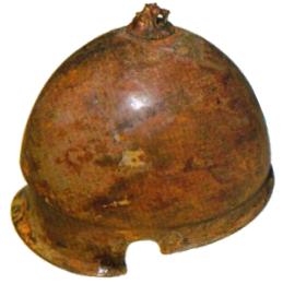
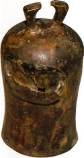
Bronze helmet coming from Les Sorres VIII (Gavà Museum, N.R.1149). 2. Smooth bronze helmet of the kind found in the bibliography as "etruskischer Helmtyp mit Stirnkehle". The front part is smooth and fluted and there are circular holes on both sides for the ears. In front of each hole there is another small hole for the hooks holding the cheek protectors. The neck is covered with a similar though wider fluting. It is crowned by a button in the shape of a lion head, with a big hole from side to side under the tongue were the mane would be placed. Present location: Gavà Museum, N.R. 1149. Dimensions: Height 20.2 cm; Length 25.5 cm; Width 18.5 cm; Thickness 0.5/3.5 mm. Weight: 1240 gr. Parallels and chronology: There are seven helmets of this type in the Berlin Museum, some of which decorated, that have been dated as belonging to the 4th and 3rd centuries BC (Bottini et alii, 1988, p.39-40, num.93/99. abb. 36). A helmet of the same type can be seen in the Etruscan collections of the Vatican Museums and another one was found in a warrior's grave in the Fosso dell'Osteria in the Vulci necropolis. This last one is now exhibited at the Villa Giulia Museum. None of these helmets has a lion head, though in some of them the circular outline of the button, now disappeared can still be seen in the upper part.
Bronze bell coming from the Les Sorres VIII sector (Gavà Museum, N.R. 241) 3. Tubular bronze bell with its edge bending outwards. It has got a mending in its middle part, done by welding a bronze plate. The hanging piece has a slightly triangular shape. Present location: Gavà Museum. N.R. 241. Dimensions: Maximum diameter: 9.3 cm; Maximum height: 17.6 cm. Thickness: 1.5-6 mm. Parallels and chronology: We hardly know any parallels. The most similar object found as far as the shape is concerned is a piece from the Roman town called Ercavica (Cuenca), though this one is a lot smaller. It can be dated from the 2nd century BC onwards.
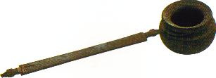
Bronze Simpulum coming from an imprecise sector in Les Sorres (Gavà Museum, A.G.R. 158). Other objects in the Gavà Museum collection could come from the same wreck, but there is no way we can confirm this fact. There is, for example, a bronze "simpulum" (Gavà Museum, N.R. 1) whose horizontal handle is decorated with two wolf heads (Aquilue & Bastit, 1985) which was found in a building site, in a pile of sand poured by a lorry. This sand was taken from an imprecise sector of the anchorage at the time when the wreck about which we talk in this article was discovered. There are lots more objects about which we do not even know when they were found. Historical backgroundThe first remains of Iberian villages found in the Llobregat lower valley can be dated from the 6th century BC. They were strategically situated in order to control the passage upstream. Three of them, belonging to this first period, also controlled the quay. These were Monjuïc (Barcelona), La Penya del Moro (Sant Just Desvern) and El Calamot (Gavà). From the 4th century BC onwards, the number of sites situated in the valley we know multiplied. Of these two gained importance: the centre of the Old Village of Sant Boi de Llobregat and Monjuïc, which form the two posts of the door leading upstream. From this period onwards, a dense network of settlements appears in this area, which were probably interdependent and lived on farming and cattle raising. At that time the countryside must have been characterised by the presence of holm oak woods in the mountains and riverbank woods in the valleys, with fields and meadows next to the villages. The large and medium-sized villages would be situated on top of the mountains, while the others would spread along the plains and the slopes of the hills. The conquest of this area by the Romans did not change the state of things much. It is not until the second half of the 2nd century BC that the presence of foreign elements starts to be noticeable. There no sign of violent destruction of Iberian villages, but just next to them the massive building of Roman villas starts, which will eventually mean the displacement of the old way of settlement, at the same time that a systematic exploitation of the resources of the land starts. It is at that time that the Can Tintorer iron mines in Gavà grow in importance. They had already been exploited by the Iberians and we must emphasise that in that area mining activities had already existed in the Neolithic period, though at that time variscite was extracted. From the last years of the 1st century BC onwards, a new Roman town called Barcino is founded, whose fate will greatly determine that of the whole of our region and of the whole of Catalonia. At the same time that the town is founded, a new layout is given to the Via Augusta, which will now run through the Llobregat valley as far as Martorell, where a stone bridge and, later, a commemorative arch are built by the Roman legions, as shown by the stonecutters marks (Fabre, Mayer, Rodà, 1984). Apart from the exploitation of the metallurgical resources of the Llobregat lower course, the intensive cultivation of a product for which there is a big demand in Rome starts: we refer to the vineyard which produced a great of wine. This low quality but competitive wine is exported initially to Gaul (during the second half of the 1st century BC) and especially to Rome (from the beginning of our era and until the middle of the 1st century AD). We can see remains of this period all over the region, since there are a lot of little villages which manufactured the wine in their own workshops (Sta. Maria de Sales in Viladecans or Ca l'Espluga in Pallejà). A consequence of this economic "boom" was the proliferation of potters that made amphorae and other containers to keep the wine and export it. We know several production spots spread all over the region, all of them having an easy outlet through a river. The economic momentum of the region, shared by the whole area known as Laietania, finished suddenly in the second half of the 1st century due to not yet clear reasons. This fact meant the abandoning, from the 2nd century onwards, of many of the sites, although we can find quite a few exceptions, and we know that some of the most important Roman monuments were built at that time: for example, the important thermal baths in the Old Town of Sant Boi de Llobregat (Puig, 1987). From the 3rd century and till the disappearance of the Roman Empire, this area has not got the power it had enjoyed in earlier times. This is proven both by the number of sites, as well as by the objects found in them. Anyway, they continue to be related to the trading currents, since we must not forget that the river valley continued to be the most important way from the coast inland and vice versa. ConclusionsAccording to the materials and the oral information that we have gathered, we have the following elements for the dating of the Les Sorres VIII wreck:
According to the judgment elements we have, it seems probable that the wreck be dated about the 2nd century BC, when all the objects found may have been in the same ship, bearing in mind bronze objects long life and the fact that there were iron anchors in the site. Because of the special circumstances that shroud the discovery of this wreck and because of the small amount of known materials, we have different possible interpretations:
All these interpretations would be possible on condition that all the materials belonged to the same set and were not the overlapping of two wrecks, a quite remote possibility of which there is however a precedent in the Grand Congloué (Benoit, 1961; Lyding-Will, 1979).
BibliographyAQUILUE, J. & BASTIT, C., 1985, Sobre un cassó de bronze romà procedent del Museu de Gavà, "La Sentiu", 8, 44-49. BENOIT, F., 1961, "L'épave du Grand Congloué à Marseille", Paris. BLAJOT, M.; GRANADOS, J.O.; JULIÀ, M.; PUIG, F. & SOLIAS, J.M., 1984, El poblamiento de la zona sur de la Layetania litoral en época ibérica y romana, "Arqueologia espacial. Coloquio sobre distribuciá¢án y relaciones entre los asentamientos", 2, 93-110. BLASCO, A. & SOLIAS, J. M., 1980, "Les àmfores romanes del Museu de Gavà", unpublished. CERDÀ, D., 1986, "El pecio del Sec", Calvià. FABRE, G.; MAYER, M. & RODÀ, I., À propos du Pont du Martorell: la participation de l'armée à l'amenagement du réseau routier de la Tarraconaise orientale sous Auguste, "Epigraphie Hispanique", 282-288. GIANFROTTA, P.A. & POMEY, P., 1981, "Archeologia Subacquea", Milano. IZQUIERDO, P., 1985 & 1986, Les Sorres: un punt d'ancoratge ibero-púnic i romà al delta occidental del Llobregat (Observació preliminar), "La Sentiu", 8 & 10, 11-22 & 11-24. IZQUIERDO, P., (1985) 1987, Algunes observacions sobre l'ancoratge de Les Sorres, al delta del riu Llobregat, "El vi a l'Antiguitat: Economia, Producció i Comerç a la Mediterrània Occidental", 133-139. IZQUIERDO, P., 1987, "L'ancoratge de Les Sorres,sota el delta del Llobregat, dins l'Economia Antiga", Thesis for Bachelor's Degree, University of Barcelona, unpublished. IZQUIERDO, P., 1987, Calamot-Can Valls del Racó-Les Sorres. Elements per a una reconstrucció de la Història Antiga de Gavà, "La Sentiu", 13, 19-27. IZQUIERDO, P., (1988), Liaisons entre navigation maritime et fluviale en Tarraconaise: les examples de Les Sorres et Dertosa, "Hommage à Nino Lamboglia", Louvain-la-Neuve, in the press. IZQUIERDO, P., (1987) 1990, L'ancoratge de Les Sorres: aportacions a l'economia antiga de la costa del Llobregat, "Fonaments", 8, in the press. IZQUIERDO, P., 1989, Notes sobre l'ancoratge de Les Sorres, "I Jornades Arqueològiques del Baix Llobregat", pre-sessions. JULIÀ, M.; PUIG, F. & SOLIAS, J.M., (1980) 1985, Introducció a l'estudi del poblament del delta del Llobregat en època ibèrica i romana, "XXV Assamblea Intercomarcal d'Estudiosos", El Prat de Llobregat, 392-413. LYDING-WILL, E., 1979, The Sestius Amphorae: a reappraisal, "Journal of Field Archaeology", 6.3, 339-350. MARQUÈS, M.A., 1983, "Les formacions quaternàries del delta del Llobregat", Barcelona. PERRONE-MERCANTI, M., 1979, "Ancorae Antiquae. Per una cronologia delle ancore del Mediterraneo", Rome. PUIG, F., 1987, Les termes romanes de Sant Boi de Llobregat, "Fonaments", 6, 61-94. SERRA RAFOLS, J. de C., 1968, Notes sobre la indústria del ferro a Catalunya abans de la romanització, "Papeles del laboratorio de arqueología de Valencia", V, 19. SOLIAS ARIS, J.M., 1983, "Excavacions a l'ermita de Ntra. Sra. de Sales (Viladecans, Baix Llobregat)", Barcelona. SOLIAS ARIS, J.M., 1985, Introducció a l'estudi de les activitats econòmiques d'una vil·la laietana, "Pyrenae", 21, 113-122. SOLIAS, J.M., 1982, "El poblament del curs inferior del Llobregat en època romana", Thesis for Bachelor's degree, University of Barcelona, unpublished. TARRADELL, M., 1977, Sobre el poblamiento romano del Pla de Barcelona, "Cuadernos de arqueología e Historia de la Ciudad", XVII, 93-97. TARRADELL, M., 1982, Costa del Baix Llobregat, "Les excavacions arqueològiques a Catalunya en els darrers anys", Barcelona, 283-284. VICENTE, J., 1967, Anforas romanas en Gavà, "Puig Castellar", 6, 2a època. |
This article was published in Spanish at REMESAL, J. & MUSO, O.: "La presencia de material etrusco en la Península Ibérica", Barcelona, (1990) 1991, p. 601-614. Published March 2000 on Nordic Underwater Archaeology with kind permission.
 Back to Nordic Underwater Archaeology