Concern for the underwater cultural heritage has gradually been growing over the last decades. The cultural value of shipwrecks and submerged sites is more and more widely recognized and local, regional and global organizations have been set up in order to promote the maritime branch of archaeology. AlMA is one. These positive developments are not by far eliminating the negative ones such as the further sophistication of treasure-hunting at sea. Nevertheless problems are better identified and one can observe a gradual shift from incidental interference with significant sites towards the deployment of general protective policies. Shipwrecks and Community or the way in which the community relates to archaeological sites, is a very important theme in this respect. Evidently many of the conference contributions deal with ways to further the involvement of the community at large. This and other issues such as environmental planning and development result in a whole shopping list of things that protectionists should do. The present paper will address some of the practicalities that are conditioning active policies and the management choices that ensue. It is, in other words, about selection. The Dutch situation with which the author is most familiar will serve to illustrate different options and a reasoned differentiation in choices. The ideas put forward may be truistic in nature, but it is contended that fundamental considerations are at the root of differences in approach that we should be aware of and accept. Dutch dunnageThe perspective from which this article is written is largely determined by the Dutch environment. Of course the cultural climate and its resultant legislation are important factors as well hut these have been dealt with elsewhere (Maarleveld, forthcoming). Here it suffices to say that in the Netherlands the Ancient Monuments Law of 1961 de facto applies to underwater sites in the territory since 1985 whereas the 1988 law explicitly includes them (Maarleveld, 1993). That is of course all rather recent. No governmental attention whatsoever has been given to the underwater cultural heritage prior to 1980, which explains awkward situations such as the continued exploitation and sale of artefacts from the ‘t Vliegent Hart site on the fringe of the territory (for a discussion of similar set-ups see: Green, 1988). The legal systematics of protection are those of a blanket declaration up to the boundary of the territorial waters (12 nautical miles) and analogous application of the Ancient Monuments Law in conjunction with permit-bound activities in the Dutch Sector of the Continental Shelf, such as sand-extraction and deep mining (Fig. 1). Moreover, specific sites can be declared protected in a more rigorous way.
The Dutch maritime environment is determined by a huge build-up of soft marine and estuarine sediments. It is the specific geological circumstances more than anything else that set the parameters for preservation, the archaeological research and archaeological heritage management. As a wetland area with a subsiding subsoil and important young sedimentation the traces of wetland and water activities can be locked in an anaerobic environment for extremely long periods, organic materials being kept in stable condition. The Pesse log-boat of 6000 BC may be the oldest instance (van Zeist. 1957), even more impressive is the Bergschenhoek extraction camp with its possible plank boat remains and its fish-traps of about 4200 BC (Fig. 2). The one was actually discovered in a landlocked peat-hog in the east of the country whereas the fragile Bergschenhoek remains were located at 8 m below ordnance datum, 8 m below the average water table and were discovered by absolute sheer chance by a very attentive passer-by when a dragline was excavating an artificial pond in a recreational area (Louwe Kooijmans, 1985). Further to seaward comparatively aged material will rest in even deeper positions. In the south-west of the country the Holocene sedimentation is more than 20 m thick. The depth of the sediments is the main difference between conditions in the Netherlands and in Denmark (Lund, 1992). Subsequent landscapes are superimposed and only have resemblances in general terms. Consequently the complete estuarine area is literally littered with well preserved remains of very varied ages. Roman Age and 12th century river boats are found in very similar environments along the course of the Lower Rhine (Vlek, 1987; de Weerd, 1988). On the one hand there is a fairly good understanding of what sequences of sediments are liable to contain important archaeological information. On the other hand, however, detailed quaternary landscape and river-course reconstruction might indicate or predict preferred or potential settlement sites, but it will not and never will indicate the more random whereabouts of boat or ship remains. Awkward as it is, this is an extremely important practical parameter for management. As a consequence it is only and absolutely only through the sequence of:
that any such remains can add to the archaeological record.
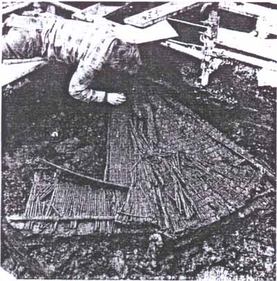
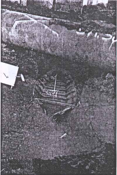
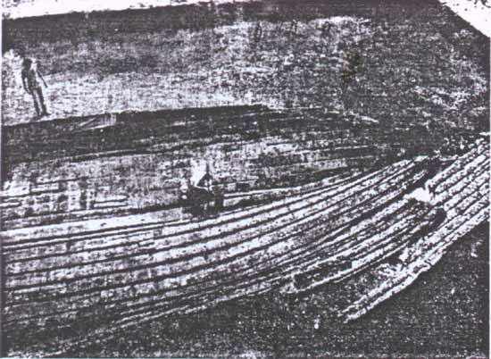
In practice this means that it is more often a relatively shallow find that is liable to be discovered and have some follow-up than that the really deep sediments do yield their archaeological information. Of course the deep sediments do get the same attention in planning. Some of the more important industrial and commercial centres like Amsterdam and Rotterdam are built and constantly adapted on (and thus in) such deep sequences of sediments in the west of the country. Also there is archaeological concern (Fig. 3), of which more below. Earthmoving techniques, however, that are used to shift deep sediments are not at all forgiving for archaeological discovery (Adams et al., 1990). The estuarine geological situation, with its general trend of a subsiding subsoil and rising sea-level offset by a generous. rate of sedimentation is, of course, complicated by frequent intrusions of the sea, erosion and subsequent renewed sedimentation. Large-scale erosion of the centre was followed by reclamation. During the last 50 years or so the remains of ships that once plied the semi-land-locked Zuiderzee turned up by the dozens (Reinders, 1986), or rather by the hundreds as the total count of ships from the 14th through the 19th century that have been surveyed or excavated in that area alone has now risen to 435 (Morel, pers. comm.). Some are modest, many are not (Fig. 4). Togethler they represent a unique outline of northwest European shipping in late medieval and early modern times. Although the shallowness of the Zuiderzee has been of great influence to processes of wrecking and site formation there is quite a number of significant vessels actually preserved to the upperworks. In this area one may presume that practically no sites went unnoticed, as the systematic digging of drainage ditches could have missed only a few. The management challenge is that reclamation equals getting the water out. Practically all shipwrecks are below the subsequent surface but the groundwater table is lowered also and dehydration means fast and utter decay.
Further to seaward, but inland of the coastal barriers, gullies are generally deeper and it is the sort of complex meandering amid shifting of these gullies that has been (and still is) responsible for problematic navigation. The relatively exposed location adds to it. hut there is no alternative, no shelter. The Dutch coast features no natural harbours. On the other hand this same shifting and meandering has determined both the encapsulation of remains in the soft sediments and renewed exposure of the same. It is a highly dynamic area where the natural cycle rather than man sets the parameters for preservation, for disclosure/discovery and for destruction. It is quite clear that the area includes large patches were Interglacial peat is preserved and others where erosion has taken place, hut where no gully or erosion-sedimentation cycle has transected or passed for several hundred years, a millennium or more. The patchwork is so complex, with comparable hut differently dated sequences adjoining that there is no way of knowing what exactly has been fossilized so to speak and what has not. But a lot has, that is for sure. The date-range should be greater than in the Zuiderzee. Without any doubt this coastal zone is one of the richest and best preserved ship-cemeteries in the world. Evidently present information extends only to sites that are currently partly exposed by the present position of gullies and present erosion. Again it is chance exposure and discovery through which information is gathered and nothing else. Not surprisingly new discoveries of shipwrecks come in groups, whenever a gully cuts into significant patches. It is the fishermen and the local divers (mostly a combination of the two) who report the 'emergence' of 'new' wrecks.
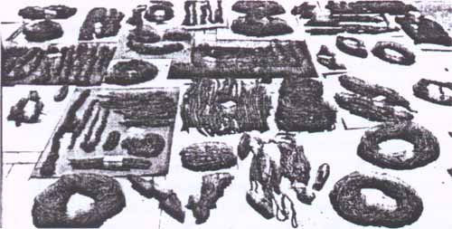
Different conditions amount to different management challenges. A simple, but tricky problem is that substantial remains will readily be reported, but that smaller ones either go unnoticed or will remain unreported as insignificant on the questionable basis that big is beautiful. Not surprisingly ships tend to be larger than in the polders. In all one is looking at some 350 sites with wooden ship remains currently exposed and reported. This is excluding the 2600 wrecks that occurred and were charted (and not cleared) since the establishment of the Hydrographic Office in 1875. At face value each of these 350 sites deserves proper attention in terms of survey and evaluation. Where excavation is decided upon, conservation conditions prove even better than in the polders. In the deeper sediments more of the upper works tend to be preserved, and consequently more of the ships' inventories (Maarleveld, 1990; Manders, 1993) (Fig. 5). ConsiderationsThe above is just an introduction, but it is also meant to point to the fact that whatever one may rightly say about scarcity, uniqueness or the rate of loss, we are facing a tremendous wealth — in the Netherlands, but evidently even more worldwide. If we want to manage that wealth consistent legislation is of course one of the very important tools. Worldwide general criteria for protection and research ethics are another set of tools. On the practical level, however, managing the underwater cultural heritage is never and will never be a question of simply applying the rules and simply adding up all the things that one should do. Rather it is a question of substraction where deliberate choices have to be made and the choice to do one thing is automatically a choice hot to do several other things. Choices vary and are conditioned by various circumstances as well as the intuition of whoever is in charge. Also, the set of choices begins very early on. Management challenges are not promoting themselves, but are identified by choice. In practical terms this leads to very different approaches from area to area (and without any doubt from one generation to another). There is nothing wrong with that. Indeed there should be. Even in a small country like the Netherlands the management challenges vary from one region to another, so they definitely do worldwide. Dutch exceptionsA major challenge that applies along the coasts of several Australian States is to combine the access to shipwreck sites with pertinent on-site background information. Continued appreciation of cultural historical values in situ is adopted as the major reason for protection (e.g. McKinnon, 1992; Strachan & Hosty, 1992). In the Dutch situation however, that approach is totally irrelevant. The deep sediments, rapid sedimentary changes and very reduced diver visibility make in sutu appreciation possible in very exceptional cases only, and even there rather specific measures have to be taken. There is one example on the outskirts of Lelystad (the main town in the polders). It is the Zeehond of 1886 (Oosting & Vlierman, 1990). After excavation the wreck was kept in its place as a marker in the landscape newly reclaimed from the sea-bed. A base and a roofing have been mounted and relevant information is displayed on site. Another example where such an approach would be useful and desirable is an 18th century wreck in the Oostvoornse Meer on the outskirts of the Rotterdam port facilities. Although the Oostvoornse Meer is a dammed estuarine branch. its underwater habitat is artificial. It was used as sand-quarry in the sixties at which time the totally encapsulated wreck (and a dozen others) evidently had been hit by the dredger. As a consequence the wreck protrudes from the bank, halfway down the steep still collapsing wall of fine sand which goes right down to 35 m. In the winter 1988-1989 the semi-disturbed part was excavated. It contained a very peculiar collection of arms: among them three huge cast-iron grenades or mortar-bombs of 150 kg each and an early 16th century swivel gun evidently in shipboard use, whereas the rest of the collection — especially a shipment of clay pipes — clearly dates the wreck to around 1735 (Kleij, 1993). Never use a cannon to date a ship! Grapeseeds, jars and olive stones indicated that the ship returned from a voyage to the Mediterranean. The hull and the undisturbed part was surveyed but left in situ. As the Oostvoornse Meer has no current, as it has depth and the clearest water you can get in Holland it is frequented by a totally different and far larger part of the diving community than that attends the coastal waters. Any Dutch diver that turns upon the Great Barrier Reef or in the Mediterranean will dive there but nowhere else in Holland. The unexcavated bit was sealed off with sand in several layers of polypropylene gauze with two layers of wire-netting in between in order to send any casually ill-willing metal detector berserk The rest, and it is a substantial piece of hull, is visitable with some effort and it would be useful to provide on site information there. As yet no information panels have been put up. The reason is the unstable position of the constantly collapsing sand wall and of the wreck within it. Neither the technical problems of stabilization nor the liability problems of signposting have so tar been solved. A third exception is again near Lelystad, in the dry, where an experiment will be run with in situ appreciation during excavation of a ship on a far larger scale than the usual visitor's days. The physically protected merchantman-site A55 has been chosen. The show and presentation will be run in close cooperation with the volunteer organization building the Batavia replica (Green & Parthesius, 1989). Displays and a sort of bridge over the excavation area will be set up. The excavation itself will be run under the authority of the State Service. Dutch decisionsBut for the exceptions above, in situ appreciation of historic shipwrecks is an irrelevant issue in the Dutch situation. As a consequence the only and decisive reason for the protection of such sites is the potential for scientific research. Accordingly, be it by choice, that is the basis for management. In consequence it is scientific potential and scientific curiosity that should drive the management. Generally speaking the greatest challenge is that one knows the most important sites to be deeply embedded and that one should be ready to act on very short notice when something shows up in the areas of prime importance. In a relatively dry situation this is not problematic. On the one hand there is a reliable network of municipal and regional archaeologists who call in the 'maritimo's' as soon as ship or boat remains turn up. On the other hand the major management challenge in the polders — dehydration — is relatively well under control through a programme of field-protection. On important sites the groundwater table is artificially raised in a simple but ingenious way. A mound of earth is erected over the site, covered with polythene sheeting in such a way that a small impluvium in the middle remains and another layer of earth is added (Reinders, 1985). Excavation can thus be postponed. Monitoring of the actual water content in dry seasons will show for how long. In this way 45 important sites were frugally set aside until now. A first assessment of a chance discovery in the dry can be carried through within the next working day. The staff that compose the team just interrupt their work for a day or two, and that does not really disrupt planning. The approach is manageable. In the submerged areas we decided it is not. But that is no reason for panic or for not doing anything at all. In the southern part, the outer delta of Rhine-Meuse and Scheidt the main challenge as we see it is in planning: to let the archaeological potential count in decision-making, in designating dredging areas and the like. The development. dredging and construction pressure is considerable. even at sea. The Malta treaty (O'Keefe, 1993) will give us better tools to interfere through Impact Studies and rescue operations: until now we have been depending only on mutual agreement with other parties concerned (Adams, et al., 1990).
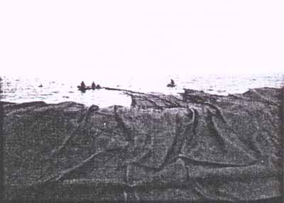
In the northern part this approach again is irrelevant. The natural environmental values of the Waddenzee are by now well enough appreciated for development possibilities to have been made very restricted. The natural environment itself, in all its dynamism is both protecting and intermittently uncovering and eroding. Although we cannot and we do not wish to stop the forces of nature, we can do so on a limited scale. Whole sites can indeed be physically protected under water. After limited survey we chose to do so at the newly 'emerged' site Burgzand Noord III in October 1988 (Fig. 6). It is about 45 m by 25 m and contains the complete broadside of an oceangoing vessel of the first half of the 17th century. By now we are pretty much convinced that it is the East Indiaman Zeerobbe that had been leased to commander Tromp as an Admiralty ship, saw action against the second Spanish Armada in 1639 and went down in the Texel roads early in 1640. The reasons for protection are as simple as convincing from a long range policy view. Eastindiaman sites are a class of sites that tend to disappear at a fast rate wherever in the world they are discovered. This relatively early one with considerable integrity can hopefully be handed over to the next generation undamaged. In order to deflect erosion the site was filled out with sand-bags. An area of 60 m by 40 m was subsequently covered in a sheet of gauze and another 6000 sand-bags were put on top. Annual monitoring has shown the procedure to be successful so far. The sand-bags act as a sediment catching artificial reef. On other Sites, deflection of erosion is to be deemed impossible. Of these only a few can evidently be chosen for in depth excavation. To show that careful excavation is possible in this hostile environment and that it yields significant results is our way to give credibility to a policy based on scientific potential. The example is partially set in order to convince the positively inclined coastal divers that archaeology is worthwhile. It is only for the negatively inclined that strict law enforcement is the only remedy. In all, the Dutch coastal area causes such an embarrassment of riches that comprehensive management is sheer utopia. This is no reason to shun a comprehensive approach. World Heritage listing of the complete Waddenzee would, for instance, do justice to its riches. On the other hand it is through carefully planned research on those selected sites that we try to avoid the traps of protection for the sake of protection, of inventorisation for the sake of inventorisation and of inspection for the sake of inspection. The choice of sites to protect and the choice of sites to excavate is driven by scientific curiosity and even scientific intuition to the background of our gradually growing knowledge of the resource and the geological and wreck formation processes involved. I am sure that many would object to the notion of intuition in this respect. I am also sure that it is a very important notion indeed where you want to protect what you do not already know in detail in advance. Managing an archaeological cornucopia with its meaning for scientific research as its basis is a constant balance between frugality and eclecticism. Above that, eclectic and idiosyncratic approaches from a purely academic background add to its significance. We are more than willing to accommodate such approaches. Subjects for academic studies abound and scholars and students at University (whether in the Netherlands or not) are welcome to come up with initiatives, in the future as in the past. Dr. Thijs J. Maarleveld ROB/NISA The Netherlands ReferencesAdams, J., van Holk, A.F.L. & Maarleveld, Th.J., 1990, Dredgers and archaeology. Shipfinds from the Slufter. Alphen aan den Rijn. Green, J., 1988, Review, International Journal of Nautical Archaeology. 17.4: 357-9. Green. J. & Parthesius, R., 1989, Comparative archaeological and historical evidence from reconstruction of the original Batavia and a modern replica. Bulletin of the Australian Institute for Maritime Archaeology, 13.2: 33-4. Kleij, P., 1993, Oostvoornsemeer Zuidoever: een Straatvaarder voor Rnttcrdam. In: R. Reimiders & van Holk, A., (eds), Scheepslading. lnieidingen gehouden tijdens het zesde Glavimans symposion, Groningen: 44-55. Louwe Kooijmans, L.P., 1985, Sporen in het land. De Nederlandse delta in de prehistorie. Amsterdam. Lund, C., 1992, Legislation and administration setup of protection of underwater cultural heritage in Denmark. Paper presented at the Eleventh Annual Conference of the Australian Institute for Maritime Archaeology. Shipwrecks and Community. 12-17 November 1992, Sydney. Maarleveld, Th.J., 1990, Het schip Scheurrak SOl. Een scheepsopgraving in de Waddenzee, Spiegel Historiael. 25: 573-7. Maarleveld, Th.J., 1993, Aanloop Molengat of lading als aanleiding. In: R. Reinders & van HoIk, A. (eds), Scheepslading. Inleidingen gehouden tijdens het zesde Glavimans symposion, Groningen: 32-43. Maarleveld, Th.J., (forthcoming), Underwater heritage management. Cultural and legislative perspective. Analecta Praehistorica Leidensia, 25. Manders, M., 1993, Twee graanschepen. Een botanische studie van de lading. In: R. Reinders & van Holk, A. (eds.), Scheepslading. Inleidingen gehouden tiydens het zesde Glavimans symposion. Groningen: 19-31. McKinnon, R., 1992, Historic shipwrecks and marine parks. Paper presented at the Eleventh Annual Conference of the Australian Institute for Maritime Archaeology, Shipwrecks and Community, 12-17 November 1992, Sydney. O'Keefe, P.J., 1993, The European Convention on the Protection of the Archaeological Heritage - relevance to maritime archaeology. Bulletin of the Australian Institute for Maritime Archaeology, 17.2: 27-30. Oosting, R. & K. Vlierman, 1990, "de zeehond" een groninger tjalk gehouwd in 1878. vergaan in 1886. Flevobericht 323. Lelystad. Reinders, R., 1985. Recent development in ship and boat archaeology in the Netherlands. In: C.O. Cederlund (ed.). Postmedieval boat and ship archaeology. British Archaeological Reports. Oxford (B.A.R. S 256): 399-412. Reinders, R., 1986. Scheepsarcheologie in Nederland. In: Koninklijke Nederlandse Oudheidkundige Bond. Verantwoord onder water, Amsterdam-Zutphen: 15-40. Reinders, H.R. & R. Oosting, 1989. Mittelalterliche Schiffsfunde in den ljsselmeerpoldern. In: H. Zitnniertnann & L. Spath (Hgg.). Ländliche und städtische Küstensiedlungen im ersten und zweiten Jahrtausend (Wilhemshavener Tage Nr.2). Wilhelmshaven: 106-122. Struchan, S. & Hosty. K., 1992. Milestone and magic: moving along on the Victorian shipwrecks trail. Paper presented at the Eleventh Annual Conference of the Australian Institute for Maritime Archaeology. Shipwrecks and Community, 12-17 November 1992. Sydney. Vlek, R., 1987. The Medieval Utrecht boat. British Archaeological Reports. Oxford (B.A.R. S382). Weerd, M.D. de, 1988, Schepen voor Zwammerdam. Amsterdam. Zeist, W. van, 1957, De Mesolithische boot van Pesse. Nieuwe Drentse Volksalmanak: 4-11. |

 Back to Nordic Underwater Archaeology