The relationship between land roads
and sea routes in the past
– some reflections
|
My starting point in this paper is maritime archaeology. In a certain respect this subject is a part of the archaeology of transport or communications. In my lectures I have always integrated an overview of the land roads and thoughts based on their connection to harbours and sea routes. The principal themes of maritime archaeology appear as ship history, "material cultural products as reflections of society", and the maritime cultural landscape. In both, communication and transport aspects are obviously of salient interest. The ships are also very relevant. I will not deny that I consider ship wrecks as unique: where do we find wagons, carts, roads and paths which give such a concentrated information both on communication and landscape as well-preserved ship wrecks, especially those with traces of their cargo? And there are indeed a lot of them in the north! The other theme, the maritime cultural landscape, has been briefly defined by me as the "network of sea routes, with harbours and related constructions and remains of human origin, under as well as above the water." It can already be discerned here that the maritime cultural landscape is par définition much more evidently marked by communication than the cultural landscape inland. The principal part of the latter is agrarian. Traces of fossil landscapes are found everywhere. Even if the sea could be considered as the "field" of the fishermen it does not leave any rune stones or bautas, grave fields, fences, cattle drives, cultivation terraces, corn plots or hollow ways for us to observe. We are forced to apply a pragmatic approach in our mapping of ancient maritime communications. A large part is based on oral tradition -the tradition of usage. And we can see clearly the connections with and similarities to inland conditions. On skerries and islands we find counterparts to the monuments inland. Sometimes we find remnants under water of the same character as the agrarian field traces, e. g. extensive fishing weirs. But it is sometimes doubtful whether all the remains of transport are connected directly to the routes. The run of the sea routes is reasonably more variable, more fluent (!) than that of the land roads. The oldest sailing descriptions -of the type periplus - do not give detailed accounts of the route followed (e.g. Westerdahl 1990). They only account for a sequence of points/ place names, in the same way we would do in the absence of a map. These points are mentioned since they have been visited or only passed -as well-known sighting points. But only a small fraction of all the possible havens or harbours are enumerated. No alternatives are given. Every known bay or channel is in itself a potential emergency harbour. But the choice of such a haven is not coincidental. It depends on cultural practice and mediated knowledge, a pattern of action. Accordingly, I have used the concept "tradition of usage". It appears (as) natural in a survey of this type to account both for similarities and differences between sea routes and land roads. Mogens Schou Jørgensen (1996) has pointed out in a diachronic perspective on hollow ways and other traces that principally all available terrain has been used along the peninsula of Jutland. Along both sides of the coast almost all the accessible waters have been utilized. Such a statement could, however, develop into a simple truism. It should therefore once more be emphasized that the choice of the way -also between a land road or a sea route- is a cultural factor, not just a manifestation of unconditional rationality, and not just a whim of the moment. It is a result of tradition and practical learning. The close connections between land and water should be considered by us as self-evident, particularly since it certainly was so for the people of the past. A sectorization of transport appears as an absurdity, now or then. But it is obvious that this close relationship is seldom taken into account in research. To one of the pioneers of geographical road research, Nils Friberg, who meant a lot to my own views of the history of roads, there was no principal difference. He himself treated roads and sea routes at the same time (e.g. Friberg 1955), at the end concentrating on the sea traffic of Stockholm, from the Bothnian hinterland (Friberg 1983) as well as from the Mälaren valley (so far unpublished). Here was found a intuitive appreciation of one of the most important nodes of both land roads and sea routes, the towns, especially port cities, and in the case of Stockholm, a typical "channel city" between two waters. Apart from channels (sounds; often with ferry traffic) to which we will return, the mouths, deltas and estuaries of rivers have been fundamental contact nodes between land, river and sea traffic. It is probable that this aspect very early attracted the wielders of power to such sites (for an archaeological effort, partly problematic, cf Farbregd 1980). Maritime cultureHaving defined as a concept the maritime cultural landscape I have to make an effort to define what I mean by maritime culture. In so doing I mark the differences towards the agrarian majority culture and thereby also towards the land roads. I would like to define maritime culture as the compound of cultural experience, the customs, the cognitive systems and the material cultural products which are created in what I have called maritime cultural centres or maritime enclaves. It finds a collective identification or illustration in intentionally created strong contrasts like that found in maritime magic. A strong mental, structural and symbolic opposition between any land- or sea-related aspect seems to be inherent in maritime culture. We all know the division imposed between `landlubbers´ and `sailors´. There is also a fundamental connection between the maritime occupations – those of the mariculturalists – from fishing by way of commercial and military navies to the light house people and the pilots. The recruitment ground seems always to be the basic economy of fishing. As a life mode maritime culture is often an expression of a spectrum of part-time occupations which each is insufficient to give a basic economy. They are not really side lines, because a basic economy then is missing. This combination is stubbornly defended. If one of these niches is threatened the emphasis is laid on another and the life mode as such survive. The common element still remains as the experience of and the demand for the boat and the sea. There is also a trait of a social security valve, expressed in anarchistic tendencies, piracy, sea robbery, wreck plunder, smuggling, and other ways of escaping the control of the authorities or of the state. It is a landscape of resistance as opposed to that of power. This facet is particularly visible in small scale shipping. Apart from this the coast is a world of its own, characterized by a rapid transmission of information. Coastal culture is potentially an innovation area. This is normal. If this mechanism does not work the reason would be other and stronger cultural factors. "An important possibility of interpretation (of maritime philology) which is common at least to most of these words (which are) characteristic for coastal culture, is the fact that communications often have been livelier between the different coastal settlements than between the coastal settlements on the one hand and the inland on the other. The coast has been a world of its own." (Modéer 1945: 39f). Maritime culture also shows a striking rapidity in transports and more extended communication lines in space in relation to terrestrian or agrarian culture. It is of course in no way without bounds but the borders are more widely spaced and different from those at land. It is often associated with living on islands. A concept like `isolation´, with the meaning `detached like an island´ (It. isola) could never have arisen in the North. It has its background in the Mediterranean, with its huge islands, where the inland has achieved an almost continental, and thereby "isolated" character (e. g. Sardinia). Almost all of those aspects of the maritime cultural landscape, which I have called attention to, serve to show the affinity with land-based phenomena, such as the power landscape, the territorial landscape, i. e. of aggression or of defence, and the cognitive or toponymous (place name) landscape. This is valid not the least for the landscape of transport or communication. But the outer resource landscape, marking the local ecology, esp. fauna & flora, including wood for shipbuilding, and the economical landscape, as mainly that of fishing, are special to the maritime sphere. The same goes for the magic or ritual landscape, lately analyzed by the author (Westerdahl 2002a & b). Feudal state, monuments, roadsIn prehistoric times roads are constructed only to a very small degree. The fragments of actual constructions that have been found consist of stone and/ or wooden foundations in wetlands and at fords. Some roadways are more the creation of nature than made by man. This fact could on its own indicate that waterways were more important. But even without such a conclusion we would reasonably guess that waterways were infinitely more attractive for any kind of heavy and extensive transport in prehistoric times. Only during the High Middle Ages do we get any kind of built roads or actual bridges. Apart from these monuments the first documented efforts at organizing the maintenance of both sea and land communication seem to start at approximately the same time. The interests of the state (or rather protostate) appear to be a decisive component in the build-up of a network of roads. In the case of the land roads it has been emphasized in research, but much less so concerning sea routes. The Swedish archaeologist Åke Hyenstrand poses this question on the Viking Age fairly early (1973): “Can the network of roads be seen in another context (than communication in general, my addition), has its build-up got an internal political significance?” The geographer Nils Friberg comments on the practical effects in during the High Middle Ages (c AD 1300) in a comparatively peripheral area, Swedish Norrland (the law in question –the Hälsinge law- was also valid in Finland) "The organization of the roads that we meet in the Hälsinge law is truly astounding. Without even any faint indication in the sparse historical sources on what has been going on, you find yourself standing in front of a fairly mature organisation in the field of roads, with a decided classification of various road types, with a maintenance regulated in details, and with settled demands on the quality of the roads" (Friberg 1951, I: 80; translation by the author). According to my argumentation (Westerdahl 1994a) feudal power is developed by ever more stable forms for:
Our interest is of course No 4. above. But all of these paragraphs seem to be intimately connected. You cannot analyze anyone of the prerequisites without keeping the others in mind. In this connection I would like to distinguish between what I have called transport pattern, transport system and transport structure (Fig 1).
Fig. 1. Sketch of the relationship between feudal powers, transport patterns, transport systems and transport structure. The latter is seen as the result of a merger of the two others. By pattern is meant the naturally grown regional variety and the system is what is put on top of it by the authorities. In feudal times the authorities can roughly be divided into king, church and aristocracy. Other interested parties are the towns and trade organizations, of the Hansa type, but in my area they do not play the same role as in the south. According to my belief the general organization belongs to the latter, i. e. the system, together with the principal roads, the conveyance by relays, reloading, ferries and pilotage. The structure is finally the amalgamation of the two. It is difficult to know what is what, especially what the underlying patterns are. Perhaps the traditional transport zones (below) belong to the original patterns. As will be pointed out they are intended for traffic on both sea and land. It is important to note that not only the physical presence of acknowledged roads is of current interest but also and even more so the traces in social organization by way of forms for construction, markings, maintenance, help for travellers, ferries, conveyance for post and couriers, control and mobilization for defence. All these factors are excellent examples of the manifestations of an all-present authority. But it is always the local peasants who have to perform the current work, the running maintenance, and also to entertain visitors sent out by the authorities, as well as to man the levy. During the Middle Ages some of these tasks are changed into permanent taxes. These taxes are canalized by way of various social levels, such as the herred (hundred, district), probably also the levy or assize district, or even the parish. With some knowledge of Nordic road history (Swedish works like Ernvik 1974, Friberg 1951, Hoppe 1945, Lassila 1972, Mannerfelt 1938-52, Schück/ Mannerfelt 1933 in Brøndsted/ Schück/ eds; 1933; Denmark: Wittendorff 1972) it is possible to infer that the establishment, maintenance and expansion of roads and transport systems to a high degree depends on the strength of the central (or anyway theoretically central) administration. As important stages in Post-Medieval times would be counted the reign of the union monarchs, the government of Gustavus Vasa (1523-60), the short Swedish epoch as a great power (Queen Christine after the ordinance of 1649), the Danish period of royal absolutism (Denmark in the 1660´s with Ole Rømer and from the 1680´s also in Norway) and the Swedish absolutism of king Gustavus III from 1772. During this last period appears an important Danish ordinance in 1793. Any change in one country is reflected in the other with corresponding systems. The first efforts at centralized sea marks and royal pilotage thus appears in Sweden with Gustav Vasa (1523-60). However, this may be very well be an illusion. Probably the process has been going on for quite some time and a dormant organization may just be mobilized by this active and well-documented ruler. The reverse happens during the periods of enfeebled rulers; the neglect of maintenance, the decay of road systems and related institutions, including ferries, conveyance, pilotage, and sea marks. The active wielders of power often find prestige in travelling itself and mark this along the roads, including the pilgrim routes. An early example would be quite a number of runic inscriptions on or by travellers (Larsson 1990). From times immemorial the means of transport marks the status of the chieftains, e. g. the wagons and carriages (Piggott 1992) or the ships (Varenius 1992). The prestige of travelling among Greek Iron Age aristocrats is apparent in the travels of Ulysses (Helms 1988). When comes the state? Look at the road!At least in Sweden the inception of the process towards a feudal state starts with the symbolic introduction of Christianity c AD 1000. As usual the archaeological sources leave out the period in the North before the Danish Jelling stone of the late 10th century. Perhaps the growth of a central kingship is much older, but unstable and “cyclical” (e. g. Hodges 1989/1982; Hedeager 1990, 1992). It seems that the protostates are slowly growing up in Denmark already during Merovingian times (late 7th century). Such striking monuments as the Kanhave canal on the island of Samsø emerge as early as AD 726, and the first parts of the gigantic Danevirke wall (late 7th century and a marked horizon in AD 737), including a massive defensive piling underwater in Slien fiord. At about the same time the first protourban settlement is founded at Ribe (AD 710-720). Then we know of the activities of the powerful king Godfred from the Carolingian imperial annals in around 800. This process of consecutive “cyclical” kingships may be finished during the reign of king Harald Blåtand, manifested by the Jelling complex and the trelleborgs. From the point of view of transportation the remarkable bridge at Ravning Enge, SW Jelling, is particularly striking (AD 979). It can be compared to the Kanhave canal or the trelleborgs in several ways. It seems e. g., never to have been repaired, which indicates its temporary nature as a prestige monument. Thus the road aspect of the first protostate seems to be an illustration of this cyclical process. The real state with irreversible bureaucratic consequences belong to a much later period, perhaps only in earnest during postmedieval times. The lower administrative levels, like the herred/ hundare are undated. They seem to exist during the 11th century (runic inscriptions of Jarlebanke in Täby, Uppland, Sweden c AD 1050, the donation of the Danish king St. Knud to the cathedral of St. Lawrence at Lund in AD 1085). Such territorial divisions must be at the basis of any road organization. According to Snorre Sturlason a legendary Yngling king was called Braut-Anund, `Road-Anund.´ It would be more reasonable to surmise that this nick-name did not belong to the Merovingian age but rather referred to the historical Christian king Anund Jakob during the first half of the 11th century. A probable ambition of these proto-feudal kings was precisely to break up the isolation of the settled areas. Local roads for heavy winter transports had certainly existed for a long time. The same goes for some water routes, although they may have been of less importance inland than at the coast or along the major rivers. None of these routes presuppose any more extensive measures. Now the turn comes to stable summer roads, cutting through the vast border forests encircling the main settlement areas or provinces of central Sweden. These forests were of such impressive extension that they got names of which the denotation is almost on a level with entire provinces: Kolmården, Kilsbergen, Tiveden, Tylöskog. Along the coast of Norrland the concentrated settlements were separated in the same way like “islands” from each other. The border forests were called Ödmården, Årskogen, Skuleskogen, Malingen. Thus the general picture of Sweden is very similar to that of Norway. For the maintenance of these principal roads rules were set up in the medieval provincial laws. These roads correspond to what has been called roads between districts (bygder), another stage after roads of the farmstead/ village and finally the internal roads of the district(bygd). The Swedish Eriksgata should be seen in this light. According to the provincial laws the king who was elected in Uppland must be confirmed in his rights and duties by the provincial assizes (ting) by way of the Eriksgata, a journey in a specific road corridor all round Lake Vättern, from Uppland and Södermanland to Östergötland och Småland (Jönköping). On the way back the provinces of Västergötland, Närke and Västmanland were visited. This was not an empty ceremony. Before the middle of the 12th century an elected king, Ragvald Knaphövde, was killed by the västgötar because he had not followed the custom of the province of giving hostage during his Eriksgata. Furthermore, the province of Västergötland had elected the Danish crown prince Magnus Nielsen (+1134 in the battle at Fotevik) king of the country. A temporary fragmentation of power was perhaps an important and necessary factor in the process towards unified power. The legitimacy of the ruler is just one aspect of the Eriksgata. The Eriksgata was also a prequisite for the maintenance of the king and his retinue (hird =perhaps from Anglo-Saxon hired= `household´). The Norse concept for this maintenance is veitsla or veizla (Swed. gästning) and is in Sweden known as wæzla from the Hälsinge law in connection with the maintenance of the konungs åre, the representative of the king. This term is, however, also known in Västergötland, perhaps significatively so, because of the strong Norwegian connection. The early medieval king had the royal demesmes at his disposal. They were in Sweden called Uppsala öd or otherwise kungsgårdar. At least 130 localities in all of the North are called Hus(e)by. They are the unalienable elements of the demesmes, belonging to the kingship irrespective of the individual. The demesmes served as stations on the incessant journeys of the king. Here were collected the produce for his maintenance during the whole year. It seems that the struggle for power was to a high degree a fight to obtain this attractive means of maintenance. The same goes for Norway (where the royal demesmes is called kongsgårde or Huseby) and Danmark (kongelev). Most of these demesmes, private or belonging to the royal family, have a strikingly route-related, communicative and maritime location (general survey in Steinnes 1955, this aspect is stressed for the Swedish localities by Larsson, G. 1986 and Larsson, M.1987). This means that at least self-interest might have spurred the actual development of road systems and conveyance on water by the early kingship of the North.. During these journeys was exerted a necessary control of the demesme and their administration. Apart from that the king exercised his royal rights as the supreme judge at the provincial assizes (landsting). A prototype seems to be possible to find in the Carolingian imperial circuitus. But it may not be necessary to look for a prototype outside of Scandinavia, although perhaps some of the ceremonial trappings may have been influenced by continental (and imperial) manifestations. Thus in the Swedish periphery of Norrland the conveyance and the maintenance of the konungs åre is sketched by the Hälsinge law. His journey went along the Norrstigen coastal road and between the Uppsala öd demesmes. A delegation of royal power has taken place even if the role of the indigenuous aristocracy may possibly be understimated. The winter journey is carried out up to northern Ångermanland (Fig. 2), which is the traditional pivot of transport, between heavy winter transportation on land and summer traffic at sea. In certain respects this transport border corresponds to a cultural border (Westerdahl 1994b). This may be a good illustration of how dependent political control is on the traditional pattern of transport.
Fig. 2. In Swedish Norrland it is possible to discern a seasonal division of traffic in two transport zones. Heavy traffic during the winter goes south of northern Ångermanland. North of this border zone, which could as well be considered a cultural border zone or a cultural barrier, traffic is upheld during summer by ship in the Baltic. This division is documented since the medieval episcopal inspections (visitations) and well into the 19th century. Monuments at roads and routes – the roads as monumentsThe runic inscriptions document the expansion of roads, while commemorating the individuals building of bridges and road banks. This process goes on during the later part of the Viking Age, as attested by archaeological datings and written source material in Denmark (Schou Jørgensen 1988), in Norway (Smedstad 1988) and in Sweden (Ambrosiani 1987). The beginning of runic monuments (c AD 500-1000) appears somewhat different. The scarce early inscriptions are more connected to graves and gravefields. But it seems to be clear that even the grave fields concentrate along ancient roads, sometimes leaving traces within the grave field. Perhaps these roads should be seen as local. Mårten Sjöbeck has made the qualified guess that gravefields and roads both are located on common land (Sjöbeck e. g. 1950). This connection with roads is not only valid for rune stones. Amongst the famous wisdom of Hávamal of the 13th century (verse 72) is emphasized that "bautasteinar standa brauto nær" (“bautas stand near to the road"). The standing stones are sometimes called brötarkumbl in the runic insription, "road marks" or perhaps rather "monuments at roads." Most of the rune stones and runic inscriptions in large boulders and rocks are found along the roads, at crossroads (some with meeting places for markets and assizes), at river fords and constructed road banks across wetlands. In that way the standing stones also serve as markings for the road in snow or poor visibility. It appears that gravefields have close connections with ancient path and road lines. Almost all of the stones refer to Christians. They were obviously intended to save the souls of either the erectors themselves or their immediate ancestors. The building of roads was encouraged by the church as a laudable action well disposed to give absolution. It is not clear whether the erectors of rune-stones as a whole belonged to the same group as the king´s immediate entourage. A fairly great number of the Southern Swedish rune texts mention thegnar (Anglo-Saxon thanes ) and drengar, which refer to proto-feudal vassalage, although it is not obvious to which king. Runic inscriptions have been carved into the 12th century, not the least in connection with churches, some of them obviously the first generation of wooden churches. Almost directly follow the Romanesque private stone churches during the 12th century as monuments commemorating the same families, possibly the direct descendants of the rune-stone erectors. It appears thus reasonable to see the rune stones, the roads and the stone churches as monuments of the ideology and the interests of similar social groups. In his fascinating study Leif Gren (Gren 1989) demonstrates how the church building in itself marks a hitherto unknown level in society, the parish. Its function was intended to weaken the old connection of the individuals to their farmstead, family and the pagan cosmology. This level was introduced by the authorities in their own interest, supported heavily by the international Catholic church. The rigid pyramidal hierarchy with its ultimate origins in classical antiquity served as the most important legitimation of royal power. The distribution of stone churches could with other words in fact give a relevant map and time sequence of the extension of feudal power. The roads are a natural sequel, with the church as the instigator even in peripheral districts, like Swedish Norrland. The archaeology of dated medieval wooden causeways has been studied in Trøndelag, Norway, by Ingrid Smedstad (1988), who compares them with the regulations of the provincial laws. In both cases the (arch) bishops were the prime factor. In my own account of the transport conditions along the medieval coast of Norrland has been emphasized the importance of medieval parish churches and centres close to the contemporary shoreline. It is probable also from the perspective of Stefan Brink (1990), that the locations of the churches are based on transport considerations and maybe also work as manifestations of strategy towards central places in the pagan landscape. Some of the inland locations are also oriented towards significant locations at inland waters or junctions. It is not just the question of the accessibility by boat or horse. At least in "my" area, Swedish Norrland, the church site (often: Vallen) has served as the local market, meeting place, the site of the assizes and sometimes as the local harbour as well. It is probable that this was an intended result of the location. The results of some archaeological excavations, e. g. in Norrbotten, may support such a view. Apart from being a monument in general, like roads, bridges, rune stones and prominent sea marks, the church building actually was a sighting point in itself. Church towers and even the church building have often served as land and sea marks. They soon became regular elements of navigation. The church tower of the cathedral in Helsingør, the tower of the St. Peter church of Rostock (126 m; cf Das Seebuch from c. 1500; Koppmann 1876) or the church of S:t Olav, now Oleviste, in Tallinn, Estonia, are justly famous. But church towers were as important in the countryside, e. g. Långe Jan in southern Öland and the church of Öja on southern Gotland, with the famous tower called "Gra gasi" ("Gray Goose"). Any other tall building, a castle or a tower, could work the same way. At the very flattish coast of Skåne the tower of the 16th century castle of Tosterup was important although it stands at least 6 kms inland. Fires in the upper storey are supposed to have warned sailors of the reefs of Sandhammaren by establishing their position. Contours of church topography are still given on sea charts during the 18th century (e.g. on northern Öland; cf for medieval England some remarks by Hutchinson 1994: 170ff). State and road in world historySome notes will be made on international parallels to the development in Scandinavia. Since the invention of the wheel road constructions are one of the most important tasks of all early states (Piggott 1983). Just observe the curious fact that the Inca empire built the most elaborate road systems without having knowledge of the wheel. For an overview of road systems see e. g. Schneider (1982: 1-11), for those of the Roman Empire Bagshawe (1979 etc), for the Middle Ages briefly in Szabó 1996, for India of the Mogul Emperors Deloche 1993-94 (the last both on land and water). It is interesting to see that these roads do not only work as army roads for external power demonstrations. They are as important for the internal control, for the couriers of the ruler, his intelligence systems and his spies. As we have stated above the decay of roads is obvious in periods of interregnum or political fragmentation. The transport systems are in a permanent need of maintenance. It may be harder to demonstrate these principles in the case of maritime transport. There is certainly an organizational ambition also at sea, but more in the sense of the mobilization of human resources. Some early exampes of importance to world history are the Phoenician and Greek thalassocracies, and later the Hellenistic and Byzantine areas of influence. Behind them lie a Minoan and Mycenaean background. None of them, however, presuppose a state formation. The mercantile thalassocracies rather seem to be notorious for their lack of unity and mobilization for common goals. They appear easily to be exploited by land-based empires (Assyrian, Persian, Roman). Their commercial rivalries must have precluded common investments in e. g. sea marks, if not in the direct interest of the state. In the medieval north the mercantile aspect is already incorporated in the making of the protofeudal state (the earliest royal towns). No such obstacles as in the Mediterranean area exist. Hærvejen, “The army road” and other Danish experiencesDenmark forms an important barrier or transit archipelago between the North Sea, the Kattegat/ Skagerak and the Baltic inner seas. At the same time it is the only point where a land traveller can minimize his sea passages to Scandinavia in the past. Denmark is therefore crucial in the North both as a transport barrier and as a mediator of land and sea transports. Presumably this area gave the pattern for other, more peripheral parts of Scandinavia. One aspect is the road along the peninsula of Jutland and its adjacent sea route(s). Another is the roads across the land from one port to another, binding the sea routes together. To give some examples of relevant connections between land roads and sea routes I have chosen mainly the Hærvejen complex. Furthermore Denmark is reasonably the earliest and most important innovation area of road networks in the north. There are several other examples of prehistoric roads in Denmark. Particularly interesting would be the stone-laid causeways of Stevns, E. Zealand in view of the exceptional Roman Iron Age finds, indicating a centre of power (Lund Hansen 1995 on the finds; and Hansen, V./ Nielsen, H. 1979 on the causeways). We have already pointed to the association of state formation and roads. However, these causeways are extremely limited in scope, being mainly very short and only situated at crossings of wetlands and fords of small rivers. But the most famous example of roads (medieval in a European sense) in the North is the Hærvejen complex. Its name is attested early but other designations exist like Kongens Hærvej, Hærstræde, Hævdvejen, Allemandsvej, Alfarvej, Alvej, Adelvej, all indicating its supreme importance for everybody and its connection to royal power. It is supposed to have followed the watersheds of Jutland, according to Mathiesens classical study (1930; after orohydrographical maps). However several new investigations have established a multitude of variations, or corridors, also differing from Mathiasen in many ways (cf Schou Jørgensen 1996). Two are running near to the coast in the east as well as there is one in the west. Wherever the road crosses a main river or the inner parts of a fiord a prerequisite arises for a nodal point of both land, river and sea traffic. The oldest reference to this road corridor appears to originate in Iceland. The Icelandic abbot Nicolaus travelled in the middle of the 12th century this way by way of Norway to Ålborg and then passing Viborg, Skodborg Å, Hedeby, Slesvig, the Eider river and Itzehoe to the Elbe. It took him two days from Ålborg to Viborg and then a week from there to Hedeby. This must mean a day´s journey of between 30 and 40 kms. This distance corresponds well to the distance between night refuges (härbärgen, själastugor) in Swedish Värmland on the pilgrim route to Nidaros or for that matter other experiences like the stages of c 40 kms a day on the route to Rome. Hærvejen was in Scandinavia the first part of the regular pilgrim land route to Santiago de Compostela or Rome. During the passage the church of Kliplev in Sønderjylland served as an important goal in its own right. The cult figure was a statue of Christ, called St. Hjælper, which is mentioned as a recipient in the will of Queen Margaret I in AD 1416. As we shall see this need not be mere coincidence. Queen Margaret I was instrumental in bringing the road organization in order. The end of this kind of traffic came with the reformation (in Denmark in AD 1536; for medieval pilgrimage in the North cf Andersson 1989). As indicated by its most wellknown name this was a military road as well. At the Hærvejen corridor several important battles took place. One of the most fateful was the battle at Grathe Hede in AD 1157, where king Svend Grathe lost his life and the glorious era of the Valdemars began in Denmark. In conformity with the common law of Queen Margaret I from AD 1396 the bailiffs of the realm were ordered to build an inn every fourth mil (30 kms) at the principal roads. These later developped into the privileged royal inns which in principle also kept this allotted distance. This is approximately what was counted as a normal day´s journey with horse and carriage at the time (more exactly 33 kms, which is in fact 4 units of a rast or a vika/ ugesøs at sea; 1 vika being 8,3 kms; below). The first regular roads with a continuous causeway or bank were constructed during the reign of king Frederk III in the 1580´s. But this kind of roads was mainly intended for the benefit of the king himself on his travels between various royal residences. Only a few of them were parallel to common roads. During the 17th century a wagon normally was driven with a speed of 4 kms an hour. This means that a day´s journey took 8 hours. However, in later ordinances an inn was stipulated for every 2 1/2 mil (=20 kms), which meant food, drink and a possible overnight stay for every fifth hour. A daily journey of 8 hours was evidently considered unrealistic even in late historical times. We return to this subject below. So far most of the maintenance still was put on the shoulders of the peasants. The Danish ordinance of 1793 expressed the opinion that those who benefit the road also must pay for its construction and maintenance. This means the local and regional authorities. The duties of the peasants were not abolished altogether but simply made more limited in scope (cf Wittendorff 1971). The direction of the later Hærvejen is connected with the extensive oxdrives from Denmark to Germany. It is indeed a general rule for the most important road courses of the past that they have been fixed and visibly deepened (hollowed) mainly by the wear and tear of hoofs, cloven or not. This goes also for the Härkätie (`the Ox road´) of Finland (cf the dissertation by Masonen 1989). The smaller tributary roads were often the pasture drives (Swed. fägata) from the village to the commons. In this case we are hitting one of the main export sales of Denmark after the great decline of agriculture during the 14th century. It was a privilege of the noblemen. During the social upheavals of the beginnings of the 16th century the burghers and peasants supporting the deposed king Christian II fought in vain against these privileges. The preserved customs documents of Gottorp show 12.000 imported oxen in 1485 rising to c. 40.000 in 1578. During the beginnings of the 17th century the annual number was 40-50.000. A slight decline can be discerned up to the introduction of the railways. A similar traffic, although not as extensive, must have taken place during the later part of the Middle Ages along the road courses named after the important river valleys of Danish Halland (Ätrastigen with the district of Redväg, `the road for riding´, Nissastigen, Lagastigen, `stig´ meaning `path, route´) and Blekinge from the Swedish provinces of Västergötland and Småland, in the same way first only succeeded by railway traffic. Like Hærvejen these approximate courses are the foundation of present-day main roads. And finally, even though the Danish cattle export had maritime alternatives, serving as such during the whole period, but only in the south and only at parts of the land roads: Korsör-Nyborg/ Assens- Årøsund (Haderslev), Rødby-Neustadt/ Travemünde (from the Baltic). On the west coast of Jutland Ringkøbing, Hjerting, Ribe, Højen (at Tønder) are well-known as cattle ports. For other cargoes, however, sea routes were parallel to the Hærvejen road courses during their whole existence, particularly along the comparatively sheltered eastern coast of Jutland. But on the western side water traffic could also be conducted inside the dunes. This route was of the same type as those used in the tidal flats of the Waddenmeer of northwestern Germany and the Netherlands. In Holland they were called "binnen de duinen" in contrast to "buiten de duinen", which exposed sailing ships to far more dangerous currents and wave action. Finally, the transit routes across the peninsula of Jutland run between the most important river ports, often medieval towns, on either side (cf Madsen 1999, Poulsen 1999). From sound to portage, bor and edThe sound is the portage of a land road, the portage is the sound of the sea route. A channel is a great asset in a coast-bound traffic. Here the sea route goes and here lie the harbours. From that point of view a pilot (Norse leiðsögumaðr, Swed. ledsaghare) could very well be called `sound-finder´ (after an idea by Henrik Breide). The title of a classical book on navigation (Taylor) is "The Haven-Finding Art", which clearly expresses what importance the protected haven has got for the direction of the sea route. On the other hand the channel is a hindrance from an inland horizon. The original meaning of `sound´ (channel) is a place where you have to swim. If you have to pass it the interruption of the land journey normally consists of a ferry transport. An alternative word for ferryman in Swedish during the late Middle Ages is sundkarl, `sound man´ (e. g. Söderwall, supplement). Bjarne Rogan uses the concept `sundmann´, which is the usual concept in Norway (Rogan 1984). To sea travellers the short overland passage between two waters plays a corresponding role. This is where you find hauling sites or portages across the isthmus. Sometimes the land transport has been so long and so frequented that you might find actual systems of hollow roads across. Apart from the phenomenon itself the place name elements drag and ed (eid) are well known in all Scandinavia. The philological root of an `ed, eid´ is a verb related to Latin `ire´ =`to walk´. These are accordingly places where you had to walk, with the necessary prerequisite that you could have gone by boat otherwise. The place names containing the Ed/Eid element are particularly prolific in Norway and in eastern and northern Sweden (cf Fig. 8). In central Middle Sweden other name elements point to the same phenomena, especially bor (Borlänge, Sundborn etc) containing direct information not given by the other names with the bor being a verbal abstractive from `bära´= `to carry´. These names do in fact also appear in Russia (cf the name of the tribe of the burjagi, `the people at a bor´(on bor cf Hesselman 1930, Widmark 1957, on the burjagi Falk 1951: 146f). In northern Scandinavia there is a multitude of Saamish and Finnish names of the same or similar denotation (e. g. muorka, muotka, matka, taival, taipale). They are a characteristic feature of the erämaa language, for the use of hunters and fishermen, for long transports in a roadless country -an "amphibious landscape"(Westerdahl 1996). But Norway is undoubtedly the country where this type of names is most evenly spread, and especially along the indented and fiord-rich coast. “They are a peculiarity of the Norwegian coast”, as the Norwegian historian Yngvar Nielsen comments in 1905. On the other hand it could also be pointed out that place names of this denotation also are found in Scotland, in a topographical situation quite similar to the Norwegian one. There are at least forty significant Tarbert sites, after the Gaelic word tarbairt for a portage, and there are many other compound names (MacCullough 1995). Inuit Greenland has got them too in similar sites, e. g. Itillersuaq, Itilleeraq (Petersen 1986: 167ff with a map). All these localities are found at narrow isthmi deep inside fiord-like landscapes where it is possible to find shortcuts from one fiord to another and to avoid weathering a cape at the open sea with dangerous waves or currents. This kind of localities is also found in less dramatic landscapes of the North (cf the list in Westerdahl 1989: 195; with reference to the Swedish Baltic coast). The Norwegian nestor of Nordic place name research, Olav Rygh gives a wide range of meanings to eid: a passage from one settlement district to another, a passage in the mountains, a road overland between two waters, rapids or currents in rivers. With such a general meaning developping over time it is not unreasonable that the named localities could point simply to a watershed, like the Russian volok, which was later also earmarked for a portage or hauling site for boats (cf Makarov 1994 on archaeological traces of such in Northern Russia). The same has happened to Swedish bor and Finnish keidas names (to the latter Swed. skede; cf Pellijeff 1967, 1989) names. The element Drag seems to have been used at sites of corresponding nature according to Rygh ”a low or shallow eid, a transition between two waters, rapids or a current in a river”. Altogether on a preliminary list there are in Norway more than 65 drag localities and at least 400 eid (after Nymoen 1995, 1997). At the Tiltereidet portage between Eidsør and Eidsvåg in Møre and Romsdal were excavated remnants of a wooden causeway, c. 500 m long and 2,5 m wide. It has been dated to the Migration Age (AD 400-550). This eid ascends to about 100 m a.s.l. Foldereid in Nord-Trøndelag has also given remains of the same kind, although they are probably later. Another well-known eid är Mannseidet on Stadlandet outside the Horn of Norway (Selje). Spangereid in Vest-Agder on the southern coast is one of the central transit points between the Norwegian traditional transport zones (cf Westerdahl 1995; Stylegar 1999 etc). The Spangereid portage has remarkably enough a canal dug in late Roman times (Stylegar/ Grimm 2003). It has also got one of the largest and richest Iron Age gravefields in these parts. This feature is not unknown from other such passages. The existence of a sizeable permanent population is a prerequisite for the proper function of a superregional eid (cf Makarov 1994 on Russia). The eid sites were important as crossways and meeting sites and accordingly churches were often built there. Then the parish name usually contains the element eid. Some of the main portages were of great strategic significance and could be controlled in troubled times by local chieftains in the name of central power, along with other alternative routes. The most common function is probably that you changed means of transport here, left your boat on one side, unloaded the cargo, carried it across the portage where you reloaded it to another vessel. If the vessel was very small it could possibly have been carried across as well. But the normal eid had probably been furnished with boats on both sides. The question is just how ordinary this way of transport has been. There are unfortunately no sources available to give any answer for earlier periods, except those very few sites dated archaeologically. In Russia it seems that similar conditions are fundamental for the understanding of state formation and of the inner communications of the Russian realms (cf Kerner 1946, Westerdahl 1992, referring to works by Jevgenij Nozov). Transports of this kind must have presupposed (more or less daily) help and assistance of people living permanently or seasonally close to the site. A Russian long volok could only be used properly when a settlement has arisen there, according to Makarov (1994). This assistance must have been almost a civic duty, even if it has not been codified in these cases. On the other hand reference to such service is mentioned in connection with the Smolensk treaties (1229, 1274) between Novgorod and the Germans and Gotlanders (Kerner 1946; App. 2. 153-54). As late as 1761 a Norwegian called Ole Olsen was called to the assizes by the bailiff, because he had been unwilling to assist in hauling a boat across the portage at Tiltereidet. Even during the 19th century these lesser transports were quite common and being mentioned in travel diaries and other contemporary texts. Some have been used up to our own times for small boats. Other early sources mention the hauling of ships for military reasons. The fleets of Norwegian kings, especially that of Harald Hårdråde at the early 1060´s were hauled across at Løgstør Bredning in Limfjorden, N Jutland, and also up into Lake Vänern in W. Sweden. Sometimes it is pointed out that it was only the smaller and lighter craft that were transported this way (Snorri Sturlason). According to the Håkonssaga of Sturla Thordarson a similar transport for military reasons -and perhaps prestige as well- happened in 1227 from Lake Vänern up into Glafsfjorden (Värmland, still Sweden) and further into Norway (the Glomma river). The concept skipsdrott (`ship haul´), which is mentioned in the Norwegian provinicial laws, must have referred primarily to the duty of hauling up boats on land in town harbours and also in winter harbours in the countryside for levy ships with boathouses (Norw. naust). But in Denmark a similar-looking place name Skibsdræt for the end of an old waterway north of Gudsø Vig on Jutland may have marked a portage of a more sophisticated kind (after an idea by Flemming Rieck, NMU Roskilde; cf Vinner 1997: 86ff). The bay of Gudsø Vig is well-known for its successive stages of defensive pilings, from the Pre-Roman Iron Age to the Viking Age. Maybe this Skibsdræt therefore has got a strategic significance. There are indeed good military reasons for hauling vessels overland, known even from later naval history in the North, in fact well into the 17th century (cf Westerdahl 1989: 257f, AD 1436, in the Swedish rhymed chronicle, Rimkrönikan II: 3005 on King Karl Knutsson, Olaus Magnus 1555 11:9 and a royal letter by king Charles IX as of Dec. 1607 in the Royal Records, Riksregistraturet) Monuments traces and remains of old roads and sea routesIn this survey I will now try to demonstrate similarities and differences between roads and sea routes by exemplifying certain elements. There is in fact a whole battery of categories to mark roads and road courses (for the Middle Ages cf Hindle 1982, Cook 1998, for the travelling itself Ohler 1989. See my fig. 3).
Fig. 3. A principal sketch of monuments and remains along land roads. A ford is often the central point. In this case it is called Vaedhil, `The Ford´, which is the original form of the name of the Danish town Vejle.This must not be taken as a direct illustration of conditions in Jutland. This situation has got many parallels, where the ford with its harbour will develop into a medieval coastal town. In the estuary of the river with the adjacent ford there are some indications of corresponding elements in a sea route (an islet called Thief´s Island, a pile barrier). Cf fig. 4.
Fig. 4. A principal sketch of a medieval coastal town at a river mouth. It could be taken as a continuation of Fig. 3. One of the intentions is to show that partly the same categories do in fact appear along the sea routes. It is however also obvious that certain remains are unique to the sea routes and their nodal points, i. e. in harbours with their boat causeways, landing stages, piers and jetties etc. But the starting point is consistently the land roads. The place names are an important part of the remnants but they have been treated very briefly. And the most important type of remains in connection with roads and sea routes is undoubtedly the settlements and traces of their organization, such as fences and other markings of ownership and use. For obvious reasons this is a much too extensive group of remains and also with a much too complicated background to be treated at all in this text. a) Traces of the road course itselfIt is only natural that most of these traces have no counterparts in the sea. But comparable traces can at least be found in the latter category. Hollow ways. The largest complexes in Sweden are to be found at Draget, close to Stäket, in Lake Mälaren, Stockholm, and at the so-called Eriksgatuleden, parish of Sandhem, Västergötland; close to Mullsjö one hollow way is 9 m deep!. No parallel in seaways. Beddings of branches, fascines (Neolithic, Denmark), planks (Bronze Age, Denmark). Without any parallel at sea, like the following: Stone-laid edge- or curbstones for wooden fill. Stone-laid beddings (Bronze Age, Denmark, Scania) Traces of roads under burial mounds (particularly Denmark) Bridges. A contact surface between ford or ferry traffic, often preceding the bridge. The bridge can secondarily be used as a barrier in the water route. Wooden causeways in wetlands (Smedstad 1988, many refs to Hajo Hayen, esp. 1957). Finds of horseshoes and horseshoe nails. Remains of fences on both sides of a narrow space (stone rows, piles). This is often the obvious traces of the small local road between the boundaries of cultivated land where the animals were driven to the pastures. Indications of old roads on historical maps and charts, either observing seemingly unmotivated jerks in boundaries or road courses, compared to air photography, perhaps to known common lands (allmänningar, fælled, e. g. Sjöbeck 1950). Old sea routes may also be found on maps. Collections of road corridors/ road bundles at fords with e.g. hollow ways. Since fords downstream a river often emerge where the current shoals and branches out this is also a topographical obstacle for a boat either way. For this reason a harbour can be foreseen both in the direction of the mouth or estuary or upstreams. Such a passage forms the basis for interaction between sea, river and land traffic, perhaps a market and even as an extension a (medieval) town (Fig. 3). Finds of wheels and parts of carts/ wagons in wetlands (Hayen 1973, Schovsbo 1987). Some could perhaps mean boat transport on wheels. It is possible here to refer to the enormous maritime heritage of means of transport, i. e. wrecks. It should only be remembered that they only indicate the route proper if they are found in inner routes or rivers. I all other cases they could have been driven there by currents and wave action. They might be found on portages in the future. Road in a parish or district border. May to some extent be compared to waterways inland where borders can be drawn for topographical reasons. But normally the settlement is on both sides of a major river valley, and the river forms a natural bond between them. Hauling sites for boats (båtdrag/ e(i)d) with traces of either wooden bedding or hollow ways (cf Draget at Stäket above). In short stretches the bedding may be succeded by canal-like ditches. This is as mentioned a classical point of contact between land and water. The Norwegian maritime archaeologist Pål Nymoen has guessed (1997) that it would be possible to find fragments of the ballast at each end of an eid. In many cases this ballast would have been reused by the vessels on that side. On the other hand most ships actually hauled over an isthmus would have been so small that they were not dependent on ballast to sail. However the thought has not been tried yet in earnest. Neither have any wheels or carts been found on portages so far. b) Remains of markingsGravefields of all categories. To be compared to certain coastal remains, esp. burial cairns, and the island chapel churchyards of the Middle Ages, sometimes misunderstood as “pest” or even “cholera” churchyards. The normal procedure was burial in one´s own parish churchyards so these are either indications of what Per Lundström once fittingly called ”harbours of strangers” or graves of unknown persons washed to the shore. Grave mounds. Road cairns (vägkummel, varder)/ mile stones. The corresponding cairns at sea are sea marks or possibly fundaments for other types of markings (cf Fig. 5). Maybe some of them could indicate various kind of distances as will been mentioned below on measuring systems. Olaus Magnus´ wood cuts from 1555 (Figs 3-4) illustrate sea marks like human figures. It is possible that he wants them to correspond to natural formations (e.g. the rock called Munken/ Lat. Monachus/ at the Faroes) or place names with the meaning of various "categories" of human beings, females or males (Käring, Karl, Kall, Gubbe etc., which all invariably point to sea marks). Other medieval and later sea marks consisted of large barrels anchored to the bottom like latter-day perches. The famous Barrel of Tønsberg, Tønsberg Tønne, in Norway was and is, however, on land. Some of them may also have left ”archaeological” traces like the cairns.
Fig. 5. Wood cut of sea marks at Bjuröklubb, Västerbotten, from från Historia de gentibus septentrionalibus AD 1555 by Olaus Magnus. Stone crosses (Some of these have maritime locations, but they were not mentioned by Olaus Magnus in 1555. On the other hand, already Saxo Grammaticus mentions a cross at Grønsund in Denmark, which was destroyed by Slavonic pirates during the 1150´s (Christensen 1980-81: 534 XIII CLXXVII). Roald Morcken believed that the Norwegian stone crosses go back to the later Viking Age (Morcken 1970, cf Birkeli 1973). Rock carvings from historical times. Crosses and other figures ( to some extent ships) are known from “skrivarsteinar” in Norway and Sweden, not the least along the pilgrim routes (Christensen 1980-81; Smedstad 1997: 196f, cf e.g., Welinder 1992 on Skrivarhällen i southern Dalarna, Bergslagen, Sweden). A great number of havens along the Nordic coasts (Sweden, Finland and Norway) contain rock carvings of ships, the arms of noblemen, dates, ship names, personal names etc. Considerably more than a hundred localities have been registered by Staffan von Arbin. Gustaf Hallström (1954) has shown that they can at least be dated back to AD 1463. "Duty stones" (Dan.`vejpligtstene´, Swed.`väglottsmärken´), marking the boundaries for stretches of road maintenance for the implicated farmer, winter and summer. Such markings are not known at the coast. But coastal peasants were charged with similar duties, applied either to sea marks during the sailing season or markings for winter routes on the ice (e.g. bundles of brush). We know of several strong exhortations by the authorities, including the king himself (e. g. the farmers of Vuono in Norrbotten in 1562; Westerdahl 1989: 164). "Dram- or piss pines" (Swed. `sup-´ or `pisstallar´). Unfortunately the valuable phosphate is soon dissipated to leave few traces in sea routes. Inns and taverns inland were often furnished with ponds to water the oxen or the horses (at Hærvejen; and Levander 1935 writing with Mathiesen 1930 as his model). Sea inns are a natural element along all sea routes in historical times, and particularly at the entrance to large harbours or port cities. There were a great number in the archipelago of Stockholm and inshore in Lake Mälaren. An unpublished catalogue of the Swedish inns is made by Nils Friberg (and once kept at the Department of Geography at Stockholm University). They are mentioned as tafernishus (taverns) in countryside Norway during the 14th century. Roald Morcken (1970) supposes a regular syatem already in this period. Sea inns have been documented in Norrbotten, Sweden, for the 1680´s by Gunnar Hoppe (1945). Only in Laje Vänern I have myself registrered 34 localities, although certainly from different periods, but beginning in the 1620`s (Westerdahl 2003). The sea inns often function as relay stations for conveyance either by boat or by horse. From the 1620´s a few stage relays are known along the Hälsingland coast (after Hedin 1939, Westerdahl 1990: 343, Fig &, 2001: 155, Fig 9e). There were relay stations of this kind even along the rivers, e. g. along the Ångermanälven river, Sweden (1660´s after Friberg 1951; here Fig. 6).
Fig. 6. Another version of the subject in Fig. 3, from the same source, but drawn with a more southern perspective in mind. The rune stones seem to indicate the run of a land road. Simple lodgings (Swed. själastugor, sæluhus) without any service at all had been put up along routes, esp. pilgrim routes, already during the 11th century according to a runic inscription from Funbo, Uppland, Sweden, Other manned stations are known from pilgrim routes (e. g. Stugun, Jämtland) to Trondheim/ Nidaros already during the 13th century. Some place names (documented in Westerdahl 1987) indicate that similar lodgings had been put up in rest- or emergency harbours in the archipelagoes if shelter in deserted seasonal fishing camps was not available. c) Remains of activities in connection with the roadMarket sites (cf Levander 1935). This is a truly maritime phenomenon as well. Harbour or beach markets are well-known from the Middle Ages in the Baltic, esp. the famous nundines scanienses (`the Scanian markets´, at Skanör/ Falsterbo). Some appear already during the Viking Age. I have mentioned the smaller sites in connnection with parish churches at the coast. Stores of trade goods, as an indication of trade along roads. There may be coastal finds but I have no good and incontestable examples. Sacrificial depots for successful travelling. Such sacrificial sites may not yet have been localized in the maritime environment. Some indications may exist in general wetland or water offerings from the Neolithic (in particular in Denmark) or the Viking Age sacrifices at Kyrksundet in Hitis, Finland (Edgren 1995). But this site may have another explanation. Olaus Magnus does in fact mention votive offerings (gloves, silken sashes) at Blå Jungfrun in Kalmarsund, S. Sweden (1555; 2:23). It is a strong suspicion that such sacrifices may have been given directly to the sea, like in the Mediterranean (anchors, pottery, cf Westerdahl 2002a & b). Holy places. Fishing and shipping chapels are found in fairly great numbers along the Nordic coasts. Generally, aspects of the ritual landscape at sea have been treated by the author recently (Westerdahl 2000a & b). Sites of assizes (ting), places of execution. It is easy to understand that assizes were summoned at places with good communication. For the sake of warning as large a part of the populace as possible the gallows were put up near to important junctions and roads, esp. immediately outside a town. There are indeed also quite a number of islands called Tjuvholmen (`Thief´s Island´) in Norway. A penetrating study of this complex was made already by Gustav Indrebø (Indrebø 1928). A large part, of not all, are more or less attested places of execution. It is the same on the Swedish side of Scandinavia. Islands with this or related names, some indicating assizes, are found near to towns. In fact they could almost be used as an indication even of other central places with legal function. At the crossing near the church of Skellefteå `Bonnstan´ Tjuvholmen was the gallows site in the middle of the 16th century (Westerdahl 1989: 191). Sacrificial cairns or heaps (`kast´ or `varp´; `offerkast´or -`offervarp´) consist either of branches and twigs or of stones. They are put up at legendary dangerous places or at a place where somebody has been attacked and/or murdered. This custom is mentioned already by Olaus Magnus in 1555 (1:31). It is sometimes unclear what distinguishes the sacrificial cairns from a general road marking, Norw. varde, Swed. kummel. It is hard to know whether this practice was general at sea but the feature itself is often mentioned in oral tradition in connection with islands. People have offered coins on, or stoned down ship wecks, of which the background was known. This goes especially for such wrecks which contained drowned members of the crew. It is interesting to note that this could be a cause for the contamination of seemingly younger objects, esp. coins, in shipwrecks. But the name element Kast- (`throw´) has also another meaning at sea. The vessel may have sailed into an area with dangerous and shallow rocks or was stuck on a shoal. To be able to put her afloat or get her generally higher in the water parts of the cargo was jettisoned. As might well be imagined this was very common in undecked vessels. This jettison was called `sjökast´, or just `kast´. The practice is mentioned in several medieval Swedish sea laws (Bjärköarätten 20, Gamla (Visby) sjörätten 11, Andra sjörätten 8 and Skeppsmålabalken XI in the common law of king Magnus Eriksson, Magnus Erikssons allmänna landslag). Defensive constructions. On land there are certainly several well-known categories. Apart from hill-forts and related works could be mentioned the seldom observed pitfalls for cavalry or pilings against horses at fords (cf Olaus Magnus 1555; 9:7, 10:24) Pilings under water is a fairly new but already fairly extensive category of construction from prehistoric and historic times. Most of them have been discovered during the last twenty years. In Denmark several have been dated to as early periods as the Pre-Roman Iron Age (the first century BC) and the Migration Age (AD 400-550). There are a few Viking Age datings in Sweden, otherwise they seem to be medieval and later. A single occurrence could in fact be Late Bronze Age (9th century BC; the Gullbro piling of Uppland). This type is so far unknown in Norway and Finland, although pilings under water occur at most medieval castles in the North which are surrounded by natural waters (Westerdahl 1989: 126ff) Place names at roadsOnly a few examples will be given here. The names of roads can denote anyone of those aspects that have been mentioned above. Some may on Hærvejen may refer to road piles, rune stones or bautas: Staghøj, Stanghøj, Sælshøj, Knaghøj, Stavshøj, to holy places: Dansehøj, Solbjerg, Stalhøj etc. There is a Pilgrimshøj in Østerløgum along the Hærvejen complex. Kors (`cross´) and Munk (`monk´)- names can mark coherent pilgrim roads (e. g. Ernvik 1955). The name element Far- refers either to land traffic, to a road or to a sea route: Farbjerg, Farsø, Farris, Ferring, Fårö, etc. The same goes for Led-. Apart from a way or course Led- can denote a gate. Topografical details are well covered; like vad =`ford´: like Ullervad, Vædil (Vejle)/Wedel in Low German, like Salzwedel, `salt ford´. The latter example indicates the transported cargo, like the Nordic name elements Salt-, Öksna- /`oxen´/ as in Engl. Saltdrive, Oxdrive, Maltdrive etc. The hundred of Redväg above (`the riding road´) in Västergötland refers to the Ätrastigen road following the valley of the river Ätran mellan ancient Sweden (Västergötland) and Denmark (Halland; other such names have been mentioned above (e. g. Nissastigen). For an exhaustive study of related transport place names in Denmark see Jørgensen 1979. In Middle Sweden the number of road names denoting the principally north/south-going esker ridges is striking. These were the driest and best possible terrain for any kind of land transport. On the Långheden, the longest of all the esker ridges and at the same time the principal road from the mining district of Bergslagen and the province of Dalarna down to the port city of Västerås in Lake Mälaren there are numerous examples of the name element Hed- `esker´, e. g. Mehedeby, `the hamlet or village in the middle of the esker´, Malm(a)-, -malm (`gravel ground´) and the most prolific Ås- which means approximately the same as ridge, but in a transferred sense also road corridor (cf Hesselman 1930). The place name types of the sea routeIn my work Norrlandsleden I (Westerdahl 1989) on the sources of the maritime cultural landscape I have accounted for a number of place name categories or types that occur in the archipelagoes and along the coasts of the Nordic countries. But the principles of name-giving are universal. By and large any possible maritime activity or aspect can be referred to in the name flora. The foremost category is the sea route names. Many of them are foundering names or denote a shipwreck. This principle was observed already by Olaus Magnus 1555 (2:28). Among this type there are names of individual ship and of a large number of ship types, such as the well-known Viking Age or medieval Snäck-, Knarr-, Kugg- but also more general and diachronic designations like Skut-, Skepp- and Båt-. Some denote nationality and origin or the profession, title or cargo of either the skipper or his ship. Warning names of dangerous places are numerous among the skerry names (once more Olaus Magnus, 1:31, 2:28). Many refer to sea marks, most of them now disappeared, but the linguistically old-fashioned form of some names may point to cairns or poles that have existed already in prehistoric times (op. cit. 1:31/12:19). One of the most important categories is the Kors- (`cross´) names. As has been mentioned above they can also denote pilgrim routes inland (e. g. Ernvik 1955, also treating names in Lake Vänern). A hafnarkross (`harbour cross´) marked many important medieval harbours The forms Korshamn, Korshavn (Krosshamn) are attested in at least four cases in the 15th century, one as early as the 1330´s (in Sweden, Denmark and Norway; Westerdahl 1989, 1993, 1995). A few localities have been named after foreign harbours, famous port cities or features in their neighbourhood. Among the archaeologically most interesting are those names which designate blockages or other intentional obstacles under water (Stäk, Steg-). Finally we have names representing the route itself or navigation in it, like Led- which often is meant in plural; for a crossroads or where the route branches off, Far- as above. There are numerous references to transit lines (me(d). Drag- and ed- names have been mentioned above. At the havens or harbours we meet several types of names either designating the location (e. g. protection from the winds), the anchor roads (Sätt-, Stad-), its installations (Kar- `stone cist or caisson´) or loading (Laberg, Lahäll), and the goods that have been handled (e. g. Korn-, Järn- `iron´). Apart from the ship building activities at a ship yard, the timber resources may be marked (Rotskär) as well as the process of rigging the hulls (Mastberget). Some of these categories indicate a world of specifically maritime phenomena, but most of them correspond to the names of the road above. Making surveys of land roadsThe only reasonable way of following road systems is by way of field work (cf Friberg 1951, but also other works by this empirically extremely conscious scholar). For example are the directions of the Hærvejen or the Eriksgata possible partly to follow on the ground, not the least in hollow ways. In the same way as the rune stones are grouped ancient monuments, not the least settlement remains with grave fields and early churches or chapels, along the ancient roads, fords and bridges. To preclude misunderstanding this should be understood as if it is the settlement that has determined the direction of the roads and not the opposite. However it has with some success been maintained by e. g. Andrew Sherratt (1995, 1996) that it could be the other way around. Details of roads, in particular those for riding, may be possible to ascertain by way of hollow ways, marking cairns and phosphate analyzes (mainly from human droppings). Archaeological projects on roads and road system är relatively uncommon. The most well-known is perhaps Ingrid Smedstad´s on wooden causeways in Middle Norway (Smedstad 1988). A sketch on a project for Swedish Ödmården, the southernmost border forest (between Gästrikland and Hälsingland) along the Norrstigen road was presented by Mats Mogren och Peter Mansson (1995). Later contributions to the discussion on road projects have been delivered by Terje Gansum, particularly on hollow roads (Gansum 1999 & 2002). Mapping older sea routesIt cannot be said that shipwrecks unconditionally indicate the waterways. They do so only in inner routes. In many cases the shipwrecks have been driven far from the foundering site, which is more likely to be on the route. On the other hand there is a clear connection between shipwreck sites and harbours or havens. Pole barriers or blockages show that somebody has tried to stop unwished-for visits along frequented routes to tempting goals. In many cases the blockages seem to have openings intended for those who knew about them. Some may have worked as the passage where customs duties were given (e. g. the pilings at the Helgeandsholmen passage, Stockholm, second half of the 13th century). The most visible remains of the sea route at land are sea marks, like older cairns and other fundaments for wooden crosses or poles. In exceptional cases they can perhaps be dated by lichenometry. It appears that the most frequented routes have got most of these markings. Some examples have been illustrated by Peter Norman (after Norman 1979, here Fig. 5) in that route which today is called King Valdemar´s Sailing Route because it was `documented´ in the Tax Register of the Danish King Valdemar Sejr (1202-41) Probably this brief sequence of place names dates from c. AD 1300 (Westerdahl 1990). Among the most secure and at the same time most difficult sources are the place names. Some can be dated fairly well. Most seem to be medieval or later. I have listed a part of the current categories above. The place name flora is always very rich along a regularly used sea route, and even richer if the archipelago consists of many islands and islets. A coastline without island is far poorer. On the other hand the choice of route is so self-evident that place names are of little use in this context. The incomparably most important sources to me have always been taken from maritime culture, from what I have called `tradition of usage´. By way of interviews and participant observation I have been able to obtain part of that tactile and direct experience which coastal people possess about their own area. But so far there have been no wholesale archaeology on sea routes. Very generally it can be said, that sea routes in the Middle Ages and forward consist of three types: 1) The inner coastal rowing route, hugging the coast, which today is grounded up and which is connected to drag and ed places at the inner part of promontories, 2) The outer route, following or hugging the coastline under sail with supporting havens at the outer parts of characteristic promontories or islands, 3) the open sea route, Norse utlei∂, at sail far out without observing the coastline as more than a thin contour at the horizon. Only prominent land marks, such as high mountains, are visible in clear weather. But this principle rather seems to give a bundle of routes concentrated in a kind of corridor than a fixed route. The harbour is the basis of what I have called centres of maritime culture, condensations of maritime remains (a fictitious one is found in Fig. 7). There the components are found as well as the connections to the land roads. Measuring systems for relay stations on land and at seaThere are clear points of contact between land roads and sea routes in older distance measuring systems. The vika (veckusjö/ uge søs) at sea is “rost at lande” according to the Östgöta law. A reasonable distance between `rests´ (raster) or reposes must be the origin of the measure called rast. According to Adolf Schück the rast was 9 kms. As we have seen above on Hærvejen the distance between the inns or taverns has been counted as 30-40 kms. But this measure is not identical with either a rast or a vika. The meaning of the maritime vika refers indeed also to the need for repose, you change rowers for every vika. This certainly happened at distinct places. Some remnants of these places are found in oral tradition. Others are documented in place names like Bytet (`The Change´), Skiftesgrundet, Ombyteshällan (`rock of change´), or Halvfaran (`Half journey´), which all mark the points where the change of rowers was supposed to come. Zilliacus (1989: 207 has other examples with the same meaning from Finland, the Ömsar- names. It is interesting that the wellknown concept `roddskede´ means relay stages or the same as a change of rowers. Several Skede- place names therefore has got a particular interest for us (cf on Skede- Pellijeff 1967, 1989)). The current localities can be marked by some natural feature, a transit line (a so-called me/d/-) or by artificial means, a cairns (varde/ kummel), some certainly used for other purposes as well, such as a general sea mark, or as a fishing site. However these localities are are very small and insignificant and never documented on maps or any other records. They cannot be found anywhere except in local tradition An older vika (veckusjö/ uge søs) is 8,3 kms. The computation of this distance was made originally by the Danish author N.E. Nørlund, who had the itinerary of King Valdemar c. AD 1300 (mentioned above) as his starting point (Nørlund 1944: 63ff). But it has been rechecked by me and by others. It seems in fact to work all over the North. At the same time is congruent with the rast above (Schück; cf the statement of the Östgöta Law). In later times there are larger measures for a vika, e. g. identical with a geographical (German) mil. The standard distance between relays at sea appears to be 4 veckusjöar =i. e. c. 32 kms. This is almost identical with half a day´s journey =33 kms (pointed out by Morcken et al). A day´s journey is accordingly 66 kms = 8 raster or 8 vikor. One instance of these distances applied can be seen between the relay points along the Hälsinge coast (Fig. 7) of Sweden. Please observe that this is the same distance as above (32-33 kms) and the same as that between the inns or taverns in the 15th-17th centuries. The stage points were on land at a distance of 4 raster from each other, at sea at a distance of 4 vikor. In both cases there were to be found changes of horses or boats (i.e. relay stations), often combined with an inn (Morcken 1970, 1978 /Hoppe 1945, Westerdahl 1990: 340ff and refs., cf Fig. 4). If a main sea route or land road has been established as to its direction these distances could be laid out to localize the reasonable relay stations/ havens, starting with 8,3-9 kms, and the larger units up to 32-33 kms. In fact in Norway it would be possible with up to 36 kms with the longer vika of 10,4 kms of Roald Morcken (1970, 1978). But it is possible that even the layout of the road/ route can be reconstructed with the aid of these measures.
Fig. 7. Seamarks and sea mark foundations (cairns, Swed. kummel) along a part of the Baltic coast of Sweden. The principal sea route is identical to that of the itinerary in the Tax Register of King Valdemar c. AD 1300. The map is redrawn after Norman 1979. ConclusionsI have tried to show the relationship between land and sea routes by way of the following: a) Similarities. The waterways are from the beginning the most important for heavy goods. Not until the Middle Ages appear impulses to create constructed and maintained roads with ensuing organization. This goes for waterways as well. It would appear as if the land roads then were the prototype of the sea routes. This is however not self-evident. I think that I can find similarities in some categories of remains common to both, in the dependence of both on the feudal state, e. g. in conveyance by relays, and a congruence in distance measures. Older sea routes, like older roads, seldom follow a fixed course but are spread out in corridors in all accessible fairwaters or terrains. The meeting places or the overlaps are found in sounds/channels, portages and the mainland harbours, esp. the estuaries or mouths of rivers. b) Parallelity. By that I mean that there is seldom a principal road, esp. at the coast, which does not have an alternative in a coastal sea route. I take as an example the two provinces of Halland and Blekinge, mainly consisting of coast, cultivated plain and forest lands with one single coastal road and one sea route. These routes meet in the river harbour, i. e. the medieval towns. The direction of the Hærvejen course and its sisters is parallel to a certain extent with the dangerous western sea route and the protected one on the eastern coast of Jutland. But this is so obvious and so simple that there is left no scope or variation for valid conclusions. A more complicated coastline with archipelagoes and promontories/ fiords would certainly give some examples of universal validity. The alternatives express the cultural choice of any travelling human being. Strikingly often land transport is chosen even in the maritime realm in Norway during the Middle Ages, possibly for status or security reasons (cf Steen 1929). c) Identity. This means simply that the waterways often were used for traffic on the ice during the winter. One example is the coastal stretch between the towns of Hudiksvall and Söderhamn in Swedish Hälsingland (Fig 8). Along this coast is a row of drag- and ed- localities, which were used during the summer in an interaction between rowing in small vessels and portage across the isthmi. In the cleared forest space of the portages it was also possible to drive a sledge. But this kind of interaction ceased when the portages had been made too long and too troublesome by way of the land uprise. In northern Fennoscandia the winter roads played a primary role. Only during the season of bare ground were the extensive waterways of the roadless interior passable by boat, but as soon as they were frozen both the waterways and the vast wetlands could be passed with relish. These routes were partly the great transhumance courses of Saami reindeer herders.
Fig. 8. Sketch of a `center for maritime culture´ along the Baltic coast of Sweden, partly based on conditions south of Stockholm.
Fig. 9. Staging points along the coast of Hälsingland. Partly the system is known from the 1620´s. Along the river Ångermanälven is is recorded from the 1660´s (after Hedin 1939, Friberg 1951). d) Coordination. Where the land road ends at the sea or at an inner waterway there is presumably a harbour, a ferrying site or a starting point for a winter road on the ice. Dan Carlsson has tried this hypothesis with remarkable success to find Late Iron Age and Viking Age harbours on Gotland. An important criterion was older maps which showed paths (some almost obliterated today) ending at the shore. Sometimes they could get together in bundles towards a distinctive point, which might have been a lagoon or a protected creek. Some actually ended at the Viking Age height curve (2 ms a. s. l.). A closer inspection could reveal gravefields or single burial cairns. Phosphate analyses and excavations have finally substantiated the suspicions. It can be added that even today the inland road may stop at the water, with a ferry or with a continuation on the ice during the winter. e) Combination. In several cases it can be discerned in prehistory how long distances can be overcome and sometimes shortened either on land or on water by way of a longer land road (so-called trans-isthmian routes after Sherratt 1996), starting and continuing by way of a longer sea transport. I have called this the intermittent way of transport. An example in the North would be the coast-bound route along southern Norrland where the S:t Olof- place names in fact appear to give the very details of that inner pilgrim route (Fig. 10) and the following land route by way of Medelpad to Jämtland and thence to Nidaros cathedral (Trøndelag, Norway). The later land-oriented course could certainly be intermittently broken by inland water transport but its principal character is that of a land route. And it was used as much during the winter as during the bare-ground season. In Swedish Bergslagen (the mining district) a very intricate and variable system on water/ice or land/snow carried the charcoal, the iron ore and the bar-iron to water-powered blast-furnaces and hammers during historical times.
Fig. 10. Portages marked by the place name elements Drag- and Ed- between Söderhamn and Hudiksvall in Hälsingland. Observe the place name Vintergatsfjärden which shows that this route overland was used during the winter (vintergata= `winter route´). f) Transport zones. By this concept is meant an area/ region with the same or similar ways of transport and means of transport. The background is to some extent an observed variation in boatbuilding, but it could also be expressed in transport means on land or seasonal communication. Another would be the adaptation to nature/ topography and to cultural or social conditions. The border of the area in question towards other transport zones may mark successive transitions to other transport techniques. Sometimes this border coincides with cultural borders inland. It is particularly interesting if you thereby can grasp those borders which form a natural cognitive unit to people of the past, their “small world", if you like. I have tried to illustrate these zones, both in a macroscale (for the coasts; Fig. 11) and schematically, in a microscale, where they can also be applied inland, and particularly in relation to waters and between such waterways (Fig. 12). The transit points where the change of means of transport or way of transport has taken place are especially evident.
Fig. 11. Place names containing S.t Olof- (St. Olav, the outstanding maritime saint of Scandinavia. These names presumably mark a sea route hugging the coast up to the switch to the land road bound for Nidaros (Trondheim), the sanctuary of the saint. Various similar names inland indicate the run of pilgrim tracks.
Fig. 12. Traditional transport zones in the North in macroscale along the coasts and inland. Frankly I do not mind very much about the differences between the world of the boat and the world of the cart. These differences are undoubtedly obvious to anyone without any long-winded explanations. Anyway some reflections have been presented above. As can be seen there is in many ways here a mixture of macro- and microperspectives. When down to details we meet the same difficult problems in the field as always. Culture/ construction or nature? Or a mixture? Concerning the sea routes it can be stated from the nature of things that the choice of direction was extremely variable. The only secure factor was the point to which traffic was directed. In prehistory and medieval times it was always the harbour, the lowest common denominator in the human world between land and sea. I would like to maintain that the similarities between sea routes and land roads are so striking that in the future we ought to look for an interpretation of the phenomena or remains both at land and at sea in the same function or anyway the same perspectives. The keywords are transport and communication in the widest sense of these concepts. Christer Westerdahl, October 2004ReferencesAmbrosiani, Björn: 1987. Vattendelar- eller Attundalandsvägen. In: Runor och runinskrifter, KVHAA Konferenser 15. Stockholm. Andersson, Lars: 1989. Pilgrimsmärken och vallfart. Medeltida pilgrimskultur i Skandinavien. Lund Studies in Medieval Archaeology 7. Lund, Diss. Bagshawe, Richard W: 1979 (o s v). Roman Roads. Shire Archaeology. Aylesbury. Birkeli, Fridtjov: 1973. Norske steinkors i tidlig middelalder. Et bidrag til belysning av overgangen fra norrøn religion til kristendom. Skr utg av Det Norske Vid Akad II. Hist-Filosof Klasse. Ny Serie. No 10. Oslo. Brink, Stefan: 1990. Sockenbildning och sockennamn. Studier i äldre territoriell indelning i Norden. Acta Academia Regiae Gustavi Adolphi LVII. Studier till en svensk ortnamnsatlas utgivna av Thorsten Andersson 14. Uppsala 1990. Brøndsted, J/ Schück, A (utg). 1933. Handel och samfärdsel. Nordisk Kultur XVI A-B. Stockholm, Oslo etc. Christensen, Arne Emil: 1995. Ship Graffiti. In: Crumlin-Pedersen/Munch Thye (Eds): The Ship as Symbol in Prehistoric and Medieval Scandinavia. Publications from the National Museum. Studies on Archaeology & History Vol. 1: 181-185. Copenhagen. Christensen, Eric (utg): 1980-81. Saxo Grammaticus Danorum Regum Heroumque Historia. Vol I. Books X-XIII. BAR Int.ser. 84 (1980), Vol II Books XIV-XVI. BAR Int. Ser. 118:1 (1981), Vol. III. Books XIV-XVI. Comm. BAR Int. Ser. 118:2 (1981). Oxford. Cook, Martin: 1998. Medieval Bridges. Shire Archaeology. Deloche, Jean: 1993-94. Transport and Communication in India. Prior to steam locomotion. Vol 1. Land Transport, Vol 2. Water Transport. New Delhi etc. Edgren, Torsten: 1995. Kyrksundet i Hitis. Ett arkeologiskt forskningsprojekt kring en av "de danska itinerariets" hamnbari sydvästra Finlands skärgård. In: Budkavlen 1995: 48-66. Åbo. Ernvik, Arvid: 1955. Olof den helige och Eskoleia. Skr utg av Värmlands museum 2. Karlstad. Ernvik, Arvid: 1974. Att resa i Värmland I-II. Stockholm. Farbregd, Oddmunn: 1980. Perspektiv på Namdalens jernalder. Undersøkingar på Veiem, Sem, Værem og Bertnem. In: Viking XLIII (1979): 20-80. Friberg, Nils: 1951. Vägarna i Västernorrlands län I-II. Stockholm och Härnösand. Gansum, Terje: 1999. Veier uten forbindelse? In: META 1/99: 24-37. Gansum, Terje/ Skarre, Tom W.: 2002. Hulveger- forslag til begreper og terminologi. I: Braut 2. Nordiske veghistoriske studier: 153-162. Lillehammer. Gren, Leif: 1989. Platon mitt i byn. Kyrksocknens uppkomst från monumentologisk synpunkt. In: Mänsklighet genom millennier. En vänbok till Åke Hyenstrand : 63-71. Stockholm. Hallström, Gustaf: 1954. Ett medeltida hällristningsdokument på Furusund. In: Svenska Kryssarklubbens Årsskrift 1954. Hansen, V/ Nielsen, H: 1979. Oldtidens veje og vadesteder belyst ved nye undersøgelser ved Stevns. In: Årbøger 1977: 72-117. Hayen, Hajo: 1957. Zur Bautechnik und Typologie der vorgeschichtlichen, frühgeschichtlichen und mittelalterlichen hölzernen Moorwege und Moorstrassen. In: Oldenburger Jahrbuch Bd 56. Teil 2: 83-190. Oldenburg. Hayen, Hajo: 1973. Räder und Wagenteile aus nordwestdeutsche Mooren. In: Nachrichten aus Niedersachsens Urgeschichte 42: 129-176. Hedeager, Lotte: 1990. Danmarks järnålder. I: Mellem stamme og stat. Aarhus. Hedeager, Lotte: 1992. Iron Age Societies. Oxford. Hedin, Alf: 1939. Hälsinglands äldsta statligt ordnade kommunikationsled. In: Gammal hälsingekultur. Hudiksvall. Helms, Mary: 1988. Ulysses´ Sail. An Ethnographic Odyssey of Power, Knowledge and Geographical Distance. Princeton. Hesselman, Bengt: 1930 (1935). Långheden och Hälsingskogen. Namnstudier kring en gammal färdväg. In: Namn och Bygd 1930: 1-53. Även i Hesselman, B: Från Marathon till Långheden. Studier över växt- och djurnamn. Uppsala 1935. Hindle, Brian Paul: 1982 (o s v). Medieval Roads. Shire Archaeology. Aylesbury. Hodges, Richard: 1989 (1982). Dark Age Economics. The origins of towns and trade AD 600-1000. London. Hoppe, Gunnar: 1945. Vägarna inom Norrbottens län. Geographica nr 10. Uppsala. Hutchinson, Gillian: 1994. Medieval Ships and Shipping. London. Indrebø, Gustav: 1928. Tjuvholmen. In: Festskrift til Qvigstad. Tromsø. Jørgensen, Bent: 1979. Stednavne og samfærdselshistorie. København. Koppmann, Karl: 1876. Das Seebuch. Mit einer nautischen Einleitung von Arthur Breusing. Mit Glossar von Christof Walter. Bremen. Kulturhistoriskt Lexikon för Nordisk Medeltid (KLNM). Larsson, Gerhard: 1986. Husabyarna- led i en forntida samhällsplanering. Tekniska högskolan i Stockholm. Medd. från inst. för fastighetstteknik, sektionen lantmäteri 4:49. Stockholm. Larsson, Mats G.: 1987. Hamnor, husabyar och ledung. Univ. of Lund, Institute of Archaeology. Report Ser. No. 29. Lund Larsson, Mats G: 1990. Runstenar och utlandsfärder. Aspekter på det senvikingatida samhället med utgångspunkt i de fasta fornlämningarna. Acta Arch Lundensia Ser i 8o, Nr 18. Diss. Lassila, Mauno: 1972. Vägarna inom Västerbottens län. Umeå. Levander, Lars: 1935. Landsväg krog och marknad. Ur samhällsdjupen i forna tider. Stockholm. Lund Hansen, Ulla: 1995. Himlingøje-Seeland-Europa. Nordiske Fortidsminder B: 13. Köbenhavn McCullough, David A.: (1995). Portages in the Norse Maritime Landscape of Scotland and the Isles (Landrovers of the Sea). A paper for the Scottish Archaeological Forum 1995: Marine and Coastal Environments Conference. Manuscript. Madsen, Per Kristian: 1999. Ribe between West and East. In: Bill, J./ Clausen, B. (Eds): Maritime Topography and the Medieval Town. PNM Vol. 4. Copenhagen: Magnus. Olaus: 1555. Historia de gentibus septentrionalibus. Romae. Nyutg. latinsk originalversion, København 1970 (Rosenkilde & Bagger), senaste nyutg. av övers. till svenska 1976, Östervåla. Makarov, Nikolay A: 1994. Portages of the Russian North. Historical geography and archaeology. In: Fennoscandia archaeologica 11. Helsinki. Mannerfelt, Måns: 1938-52. Västgötavägar I-IV. Uppsala etc. Masonen, Jaakko: 1989. Hämeen härkätie. Synty ja varhaisvaiheet. Tiemuseon julkaisuja 4. Helsinki. Engl. summary. Mathiesen, Hugo: 1930. Hærvejen. En tusindaarig Vej fra Viborg til Danevirke. En historisk-geografisk Studie. København. 13 upplagor till 1981! Modéer, Ivar: 1945. Svenska kustnamn som vittnesbörd om sjöfartsförbindelser med utlandet. In: Saga och Sed. Kgl Gustav Adolfs Akademiens Årsbok. Uppsala. Mogren, Mats & Mansson, Peter: 1995. Ödmårdens fjärrleder. Något om de vita fläckarnas arkeologi och om ett projekt i startgroparna. I: META 95:1: 65-86. Lund. Morcken, Roald: 1970. Europas eldste sjømerker. In: Sjøfartshistorisk Årsbok 1969. Foreningen Bergens Sjøfartsmuseum. Morcken, Roald: 1978. Veien mot nord. Vikingetidens distansetabell langs den norske kyst fra svenskegrensen til Hvitehavet. In: Sjøfartshistorisk Årbok 1978. Foreningen Bergens Sjøfartsmuseum. Nielsen, Yngvar: 1905. Middelalderske samfærdselslinier i Norge, langs kysten og paa indsøer og elve. In: Norges Geografiske Selskabs Aarbog XVI. Christiania. Norman, Peter: 1979. Båkar och kummel i Loftahammars och Östra Eds skärgårdar. In: Tjustbygden 1979. Västervik. Nymoen, Pål Aage: 1995. Sjøveien over land -om eid og drag i Midt-Norge. In: Spor 1/95: 34-36. Trondheim. Nymoen, Pål Aa.: 1997 (” Det er en eiendommelighed ved den norske kyst…”) Om eidenes betydning for ferdsel til sjøs. In: Kysten 1997 nr 1: 16-20. Nørlund, N.E.: 1944. De gamle danske længdeenheder. Det Kongelige Danske Videnskabernes Selskab. København. Avec un résume en francais. Ohler, Norbert: 1989. The Medieval Traveller. Woodbridge. Pellijeff, Gunnar: 1967. Archaeology and placenames. Excursus. In: Hagberg, U-E: The Archaeology of Skedemosse II. The Votive deposit in the Skedemosse Fen and their Relation to the Iron Age Settlement on Öland, Sweden. The Royal Academy of Letters, History and Amntiquities. Stockholm. Pellijeff, Gunnar: 1989. Ortnamnselementet skede. In: Peterson, L (et al., red): Studia Onomastica. Festskrift till Thorsten Andersson: 279-286. Stockholm. Petersen, H. C.: 1986. Skinboats of Greenland. Ships and Boats of the North. Vol. 1. Roskilde: 167ff. Piggott, Stuart: 1983. The Earliest Wheeled Vehicles From the Atlantic Coast to the Caspian Sea. London. Piggott, Stuart: 1992. Wagon, Chariot and Carriage. Symbols and Status in the History of Transport. London. Poulsen, Bjørn: 1999. Wagons and ships. In: Bill, J/ Clausen, B (Eds): Maritime Topography and the Medieval Town. PNM Vol. 4. Copenhagen: 203-212. Rogan, Bjarne: 1984. Om sundmenn og ferjevesen. Et bidrag til norsk samferdsels- og reiselivshistorie. In: Norveg. Folkelivsgransking 27 (1984): 97-156. Schneider, Hans-Christian: 1982. Altstrassenforschung. Darmstadt Schou Jørgensen, Mogens: 1988. Vej, vejstrøg og vejspærring. Jernalderens landfærdsel. In: Mortensen, P./ Rasmussen, B. M. (red): Jernalderens stammesamfund. Fra stamme til stat i Danmark 1. Århus: 101-116. Schou Jørgensen, Mogens: 1996. Oldtidens veje i Danmark. Nogle aspekter af en forhistoriske landfærdsel. In: Braut 1. Nordiske Vejhistoriske Studier: 37- 62. Viborg. Schovsbo, Per Ole. 1987. Oldtidens vogne i Norden. Frederikshavn. Diss. Sherratt, Andrew: 1995. Reviving the grand narrative. Archaeology and Long-Term Change. In: Journal of European Archaeology 3/1) 1995: 1-32. Sherratt, Andrew: 1996. Why Wessex? The Avon route and river transport in later British prehistory. In: Oxford Journal of Archaeology Vol 15 (2): 211-234. Sjöbeck, Mårten: 1949. Bleking. Stockholm. Smedstad, I: 1988. Etableringen av et organisert veihold i Midt-Norge i tidlig historisk tid.Varia 16. Oslo. Smedstad, Ingrid: 1997. Norske pilegrimsveier til Nidaros. In: Rumnar, L (red): Helgonet i Nidaros. Olavskult och kristnande i Norden. Skr. utg av Riksarkivet 3: 189-207. Jyväskylä. Steen, Sverrie: 1929. Ferd og Fest. Oslo Steinnes, Asgaut: 1955. Husebyer. Den norske historiske forening. Skrifter 32. Oslo. Stylegar, Frans-Arne: 1999. Spangereid. En sørlandsk saga. Kristiansand. Stylegar, Frans-Arne/ Grimm, Oliver: 2003. Ein Kanal der Spätkaiser- und Völkerwanderungszeit in Spangereied, Südnorwegen. In: Archäologisches Korrespondenzblatt 3/2003. Szabó, Thomas: 1996. Der Übergang von er Antike zum Mittelalter am Beispiel des Strassennetzes. In: Lindgren, Uta (Hrsg): Europäische Technik im Mittelalter: 25-43. Berlin. Varenius, Björn: 1992. Det nordiska skeppet. Teknologi och samhällsstrategi i vikingatid och medeltid. Stockholms Studies in Archaeology 10. Diss. Welinder, Stig: 1992. Människor och landskap. Soc. Arch. Upsal. Aun 15. Uppsala. Westerdahl, Christer: 1987a. Die maritime Kulturlandschaft. Schiffe, Schiffahrtswege, Häfen. Überlegungen zu einem Forschungsansatz. Deutsches Schiffahrtsarchiv 9, 1986. Bremerhaven: 7--58. 29 ill (utkom 1987). Rec Hansische Geschichtsblätter 1987: 113 (Hans Walther Keweloh). Westerdahl, Christer: 1987b. Norrlandsleden II. Beskrivning av det maritima kulturlandskapet. Rapport från en inventering i Norrland och norra Roslagen 1975-1980. Arkiv för norrländsk hembygdsforskning XXIII. Härnösand. Westerdahl, Christer: 1989: Norrlandsleden I. Källor till det maritima kulturlandskapet. Arkiv för norrländsk hembygdsforskning XXIV. Härnösand. Westerdahl, Christer 1990. The Maritime Itinerary of the Tax Register of King Valdemar Sejr of Denmark (1202-1241). In: Deutsches Schiffahrtmuseum 1990: 326-375. Westerdahl, Christer: 1992. Verkehrstechnik auf Binnenstrassen in Russland zur Wikingerzeit. In: Deutsches Schiffahrtsarchiv 15 1992: 83-104. Westerdahl, Christer: 1993. Medeltida ortnamn. Etn översikt över system och former i det maritima kulturlandskapet längs Norrlandskusten. In: Svensson, I./ Westerdahl, C./ Mellander, J (red): Bottnisk Kontakt VI: 86-95. Gävle. Westerdahl, Christer: 1994a. Statsbildningsprocess och medeltida transportstrukturer. I: Grundberg, L/ Nykvist, P (red): En norrlandsbygd möter omvärlden. Styresholmsprojektets skrifter 3: 145-160. Härnösand. Westerdahl, Christer: 1994b. Kulturgränszonen i norra Ångermanland. Dess yttringar under ett längre tidsperspektiv och några förslag till förklaringar. I: Edlund, Lars-Erik (utg.): Kulturgränser- myt eller verklighet.DIABAS 4.: 309-327. Umeå. Westerdahl, Christer: 1995. Det maritima kulturlandskapet- ett återseende. In: Marinarkeologi. Kunnskapsbehov. Rapport fra seminar 22.25. september 1993, Korshavn ved Lindesnes. Norges Forskningsråd (FOK-programmet): 95-102. Oslo. Westerdahl, Christer: 1996. Amphibian transport systems in northern Europe. A survey of a medieval way of life. In: Fennoscandia archaeologica XIII: 69-82. Westerdahl, Christer: 2001. Kyrkan, ledungen och gränsen kring inre Botten (1346 och 1374). Ett tolkningsförsök av den feodala överhetens transportorganisation i området. I: Morney, J.(red): Bottnisk Kontakt X: 141-162. Vasa. Westerdahl, Christer: 2002a. The ritual landscape at sea. In: Krueger, K./Cederlund, C.O. (Eds): 2002. Maritime Archäologie heute. Maritime Archaeology Today. 3rd International Marine Archaeological Conference of the Baltic Sea Area (2001): 51-72. Rostock. Westerdahl, Christer: 2002b. Vänerns magi. Sjöns rituella landskap. I: Vid Vänern- natur och kultur. Vänermuseets årsbok 2002: 42-77. Lidköping. Westerdahl, Christer: 2003. Holy, profane and political. Territoriality- extraterritoriality. A problem with borders. Some notes and reflections. I: Bäärnhielm, G (et al. red.): Accurata descriptio. Studier i kartografi, numismatik, orientalistik och biblioteksväsen tillägnade Ulla Ehrensvärd. Kungliga Biblioteket, Stockholm 2002: 467-495. Widmark, Gusten: 1957. Ordet bor som appellativ och ortnamnselement. In: Namn och Bygd. Uppsala. Vinner, Max: 1997. Med vikingen som lods ved den danske kyst. Roskilde. Wittendorff, Alex: 1971. Alvej og Kongevej. København. Zilliacus, Kurt: 1989. Skärgårdsnamn. Sve. Litt. sällskapet i Finland nr 558. Helsingfors. E.g. Fahren und Reiten in Reallex der Germ Altertumskunde 8, 1991, or corresponding stuff in the KLNM. |
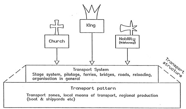
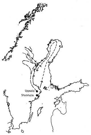
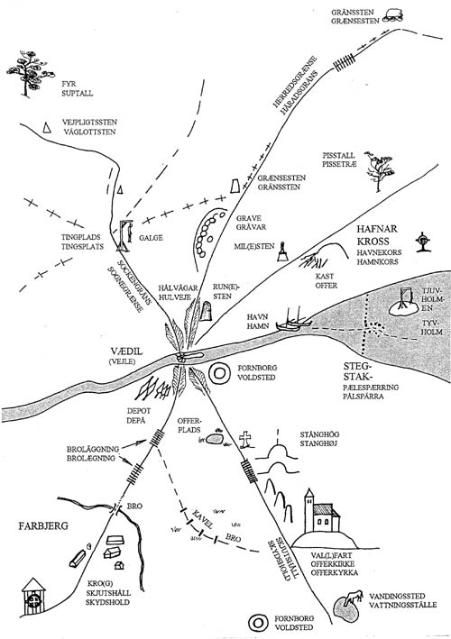
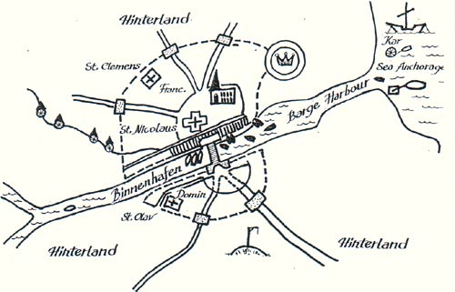
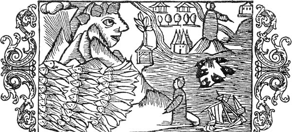
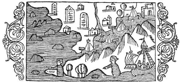
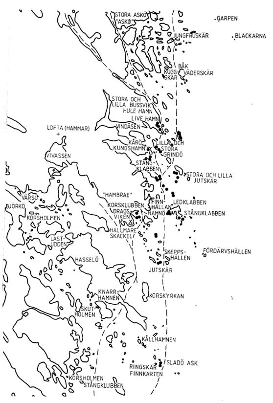
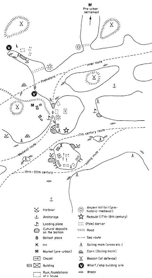
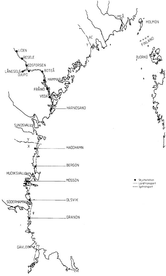
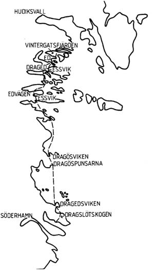
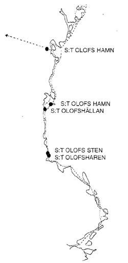
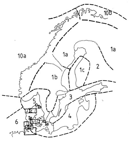
 Back to Nordic Underwater Archaeology