|
Maritime archaeology has only relatively recently entered the political agenda, albeit mostly in a very modest way. Nevertheless one can certainly consider this specific field as an integral part of cultural politics. Viewed in that perspective it is small wonder that there are marked differences in the way things are being done in one country or another. Clearly there are marked differences in the way the maritime heritage is reflected upon. The role that the present day community allots to it, has considerable impact on the way its archaeological disclosure or protection can set about. In the present article it will be ventured to outline some of the parameters to which maritime archaeology in the Netherlands presently conforms and to explain some of the resultant policy choices. Cultural environmentWithout taking too deterministic a stand one can safely state that cultural policies will (and should) align with the general cultural climate in the community for which they operate. In the case of archaeological policies it is at least as important that they should sensibly relate to environmental factors, as those factors are responsible for differential conservation. For policies concerning the underwater heritage, moreover, environmental factors have a strong additional effect on their implementation. The world over one can discern a wide range of approaches. The specific choices are possibly more outspoken at present than in other heritage disciplines, due to the relative youth of the sector. Between Sweden and the Netherlands the analogies seem to be more conspicious than the differences. In both countries maritime archaeology has firm roots in the same cultural traditions. The striking fact is that in both countries developments seem to be the result of the dialectic interaction of exactly the same two lines of approach. Elsewhere I have tried to analyse such developments in a broader perspective (Maarleveld, forthcoming). On the present occasion it might just be clarifying to summarize some characteristics of the two interacting traditions. On the one hand both Sweden and the Netherlands have a long-standing tradition of archaeological field-research and archaeological heritage management which is simply being extended beyond the limits set by the waterline. Important characteristics are:
On the other hand both countries are strongly influenced by a totally different traditon which can be characterized as follows:
In both countries the two traditions clash and interact. Significant occasions have been the discussions concerning the relative importance or necessity of research and excavation of 'yet another man-of-war' in Sweden in the early eighties at the start on the Kronan project (see Westerdahl et al., 1982) and (in a far more malign disguise) the discussions about the desirability of a National Museum's involvement in salvage-projects for the benefit of the antiquities-market like the Hollandia and 'T Vliegent Hart expeditions in the Netherlands. The latter discussions (and the strong condemnations that went with them) inevitably prejudiced the more or less simultaneous discussions about involvement in the Amsterdam project which amongst other things entails the removal of an archaeological site from one country to another (Reinders, 1986a; Brand et al., 1987). Where ever one stands, it would be a negation of the fundamental dichotomy in traditions to just discard the arguments on either side as silly. Both are to deeply embedded for that.
Physical environmentThe Dutch maritime environment is determined by a huge build-up of soft marine and estuarine sediments. It is the specific geological circumstances more than anything else that set the parameters for preservation, for archaeological research and archaeological heritage management. As a wetland area with a subseding subsoil and important young sedimentation the traces of wetland and water activities can be locked in an anaerobic environment for extremely long periods, organic materials being kept in stable condition. The Pesse 'logboat' of 6000 BC may be the oldest instance (van Zeist, 1957), more impressive is the Bergschenhoek extraction camp with its possible plank boat remains and its fishtraps of about 4200 BC. The one was actually discovered in a landlocked peatbog in the east of the country, in find circumstances that could occur elsewhere on the Northwest European Plain. The fragile Bergschenhoek remains are more typical for the situation in the Dutch coastal region, even be it some 30 kilometers inshore. They were located at eight meters below ordnance datum, eight meters below the average water table and were discovered absolutely by sheer chance by a very attentive passerby when a dragline was excavating an artificial pond in a recreational area (Louwe Kooijmans, 1985). Further to seaward comparatively aged material will rest in even deeper positions. In the Southwest of the country the Holocene sedimentation is more than 20 m thick. The geology is the main difference between conditions in the Netherlands and in Sweden. Even the submerged landscapes in southern Sweden are very different from the Dutch situation. The depth of the sediments is so much greater in the Netherlands: subsequent landscapes are superimposed and only have resemblances in general terms. Consequently the complete estuarine area is literally littered with well preserved remains of very varied ages. Roman Age and 12th century riverboats are for instance found in very similar environments along the course of the Lower Rhine (Vlek, 1987; de Weerd, 1988). Management parametersWhere a national policy for heritage management in the Netherlands was to be developed during the eighties it was quite evident that whatever the specific interest in remains of 'Dutch' culture or historically 'Dutch' activities elsewhere in the world, this policy should primarily be in keeping with the present-day political identity. In other words the primary goal was to take responsibility for the heritage presently under Dutch jurisdiction (and this irrespective of its original cultural affiliation). In terms of traditions the policy was to give primacy of the first over the latter indicated above. Although the immediate cause for policy-formulation was to be found in antiquarian and treasure-hunting incidents, it was resolved that these should not overrule an overall approach, even where they were of great consequence (Weber, 1987; Maarleveld, 1993). The physical parameters are thus to be given good consideration. There is a fairly good understanding of what sequences of sediments are liable to contain important archaeological information. On the other hand, however, detailed quaternary landscape and river-course reconstruction might indicate or predict preferred or potential settlement sites, but it will not and never will indicate the more random whereabouts of boat or ship remains. Awkward as it is, this is an extremely important practical parameter for management. As a consequence it is only and absolutely only through the sequence of:
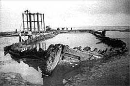
In practice this means that it is more often a relatively shallow find that is liable to be discovered and have some follow-up than that the really deep sediments do yield their archaeological information. Moreover, earthmoving techniques that are used to shift deep sediments are not at all forgiving for archaeological discovery (Adams et al., 1990). The estuarine geological situation displays a general trend of a subseding subsoil and rising sea-level offset by a generous rate of sedimentation. The situation has, however, been complicated by frequent intrusions of the sea, erosion and subsequent renewed sedimentation. Large-scale erosion of the centre was followed by reclamation. During the last 50 years or so the remains of ships that once plied the semi-land-locked Zuiderzee turned up by the dozens (Reinders, 1986b), or rather by the hundreds as the total count of ships from the 14th through the 19th century that have been surveyed or excavated in that area alone has now risen to 435 (Morel, pers.comm.). Together they represent a unique outline of Northwest-European shipping in late medieval and early modern times. Although the shallowness of the former Zuiderzee has been of great influence to processes of wrecking and site formation there is quite a number of significant vessels actually preserved to the upperworks. In this area one may presume that practically no sites went unnoticed, as the systematic digging of drainage ditches could have missed only a few. The management challenge is that reclamation equals getting the water out. Practically all shipwrecks are below the subsequent surface but the groundwater table is lowered also and dehydration means fast and utter decay. Further to seaward, but inland of the coastal barriers, gullies are generally deeper and it is the sort of complex meandering and shifting of these gullies that has been (and still is) responsible for problematic navigation. The relatively exposed location adds to it, but there is no alternative, no shelter. The Dutch coast features no natural harbours. On the other hand this same shifting and meandering has determined both the encapsulation of remains in the soft sediments and renewed exposure of the same. It is a highly dynamic area where the natural cycle rather than man sets the parameters for preservation, for disclosure/discovery and for destruction. It is quite clear that the area includes large patches were Interglacial peat is preserved and others where erosion has taken place, but where no gully or erosion-sedimentation cycle has transected or passed for several hundred years, a millennium or more. The patchwork is so complex, with comparable but differently dated sequences adjoining that there is no way of knowing what exactly has been fossilized so to speak and what has not. But a lot has, that is for sure. The date-range should be greater than in the Zuiderzee. Without any doubt this coastal zone is one of the richest and best preserving ship-cemeteries in the world. Present information evidently extends only to sites that are presently partly exposed by the present position of gullies and present erosion. Again it is chance exposure and discovery through which information is gathered and nothing else. Not surprisingly new discoveries of shipwrecks come in groups whenever a gully cuts into significant patches. It is the fishermen and the local divers (mostly a combination of the two) who report the 'emergence' of 'new' wrecks. A simple, but tricky problem is that substantial remains will readily be reported, but that smaller ones either go unnoticed or will remain unreported as insignificant on the questionable basis that big is beautiful. Not surprisingly shipfinds in the coastal waters tend to be larger than in the polders. In all one is looking at some 350 sites with wooden ship remains currently exposed and reported. This is excluding the 2600 wrecks that occurred and where charted (and not cleared) since the establishment of the Hydrographic Office in 1875. At face value each of these 350 sites deserves proper attention in terms of survey and evaluation. Where excavation is decided to conservation conditions prove to be even better than in the polders. In the deeper sediments more of the upper works tend to be preserved, and consequently more of the ship's inventories (Maarleveld, 1990; Manders, 1993; Zeiler, 1993). DiscussionThe above is just an introduction, but it is also meant to point to the fact that whatever one may rightly say about scarcity, uniqueness or the rate of loss, we are facing a tremendous wealth. It is a wealth of which both the (enormous) quantity and the fantastic quality in terms of archaeological integrity can now be grasped. When viewed in a worldwide perspective the unique dynamics of the Dutch coastal area have created an archaeological preserve that should be allotted the status of World Heritage. Important tools for the management of that wealth are consistent legislation, general criteria for protection and, of course, research ethics. On the practical level, however, managing the underwater cultural heritage is never and will never be a question of simply applying the rules and simply adding up all the things that one should do. Rather it is a question of substraction where deliberate choices have to be made and the choice to do one thing is automatically a choice not to do several other things. The choices that have been made over the last decade in a gradually developing management policy were intended to fall into a consistent pattern and to set precedents for the future. Management choicesThe primacy of research To begin with we should be very clear on what to protect and for what reason. Protection of cultural heritage is a rather general concept which can be implemented in several different ways according to several different basic assumptions. These various points of departure are indeed incorporated in the Dutch legislation in that the Ancient Monuments Law is put in very general terms. The association of a site with a particular historic event can be a reason for its protection, so can its beauty or its cultural or cultural-historical significance. Vague or specific as these motives may be, they all to some extent imply the possibility of participation to the inherent values by the general public. Under the circumstances we have come across while discussing the preservation of maritime archaeological sites in the Netherlands this is hardly ever the case. The only real reason in other words for the protection of cultural heritage under the circumstances we discussed is the potential these remains have to contribute to our aggregate knowledge and understanding of past society when submitted to scrupulous investigation. Research is the ultimate reason for protection, as it is only through research that relevant information can be added to the archaeological record. Giving primacy to archaeological research is a clearcut choice in management policy. It implies that protection becomes an instrument for temporization of field-studies, for the frugal dealing with a finite resource that will ultimately be sacrificed to our schemes of systematically adding to our knowledge. It also implies – and I'm fully aware of the controversial nature of that implication – that there is no ground to put any effort in the protection of sites of which it is more or less clear that they will not be given any attention to in the more or less foreseeable future. After all policy-making consists only half in making sure that funds will be made available for dealing with the maritime cultural heritage, the other half consisting in allocating the available funds in the best possible way. This means choices between sites and choices between areas. Even though the legislation allows for the protection of any site more than fifty years old no attention will – and presumably so for some time to come – be given to any site which can be dated to our present century. In the same line a low priority is being given to late-nineteenth century sites. Such choices are the result of considering the plenty in relationship to the means to do something about it, which will always be restricted. Similarly, clearcut choices are being made to give preference to areas of generally good preservation over those primarily featuring scattered wreck-sites. It is the natural circumstances, the extreme richness of the archaeological remains and the primacy of archaeological research that determine such choices. Wrecksites versus submerged sites In practice all attention for underwater sites – both in protection and research – is concentrated on sites with a strong maritime association such as wreck-sites or the sites of cross-channel-connections. This, however, is not a choice on principle. The reason for it is quite simple: in the Netherlands the borderline between water and land has been subject to quite a bit of change over the centuries. This means that submerged and buried settlement sites are liable to occur within or outside the dikes of present-day polders. In an underwater environment, however, they tend not to be easily recognized as such. Also, working under open water is far more exacting and expensive than working under the ground-water table in an otherwise dry site. In other words one should have extremely good reasons to tackle an underwater site in preference of one in a drained wetland environment. In the Dutch situation the reasons to do so are slim where settlement sites are concerned. Localizing and inventory A well-balanced management policy is ideally based on as good an inventory as possible. On the one hand, however, it is an illusion that such an inventory will ever be complete, as presumably most sites – and possibly the most important ones amongst them – occur in a deeply buried location. In managing, an inventory is just a tool, an important tool, but it is of little significance when no measures or research ensue. Also one should be very much aware of the fact that an inventory has strong limitations, especially in those areas which on the basis of their physical characteristics can be considered to be the most significant. That being the case the position of a professional department responsible for cultural heritage management and its policy towards localizing and inventory of sites should be well-considered. Drafting and completion of an inventory should never demand too high a percentage of the available professional archaeological endeavours. The present parameters in the Netherlands are such that in drafting an inventory of underwater sites, the work of the Department of Underwater Archaeology (AAO) is primarily based on the information from others. By law everyone who finds something which he knows or can reasonably suspect to constitute a monument (anything of archaeological value that is) is obliged to report this. Partly these 'others' are government agencies and administrative bodies such as water board authorities and public works departments, partly they consist of private persons or organizations, contracting firms, sports divers and the like. It is highly preferable to take their reports as a basis for further work rather than to make every effort to localize as yet unknown sites. It is their information which is the basis for the deployment of archaeologists, either professionally or on an avocational basis. Through on-site assessment these try to enlarge the scope and quality of the inventory, rather than the quantity of its entries. Protection versus research On-site assessment has twofold aims. On the one hand the surveyor is concerned with the value of the archaeological site as such – what seems to be there: What date? What state of preservation? On the other hand he is immediately concerned with an assessment of the immediate and future preservation. Is erosion in progress? At what pace? Will protective measures be of avail, and at what costs? An underwater survey in the Dutch situation will almost always be concerned with a site at the bottom surface that is discovered due to erosion or to digging or dredging activity. This means that threats abound and generally speaking the most logical consequence, the most off-hand solution, would be research; superficial research in case the site is of minor interest and very thorough research whenever a site is deemed more important. Now from a managerial point of view this is both impossible and undesirable. It is impossible for the simple reason that thorough on-site investigation and excavation work is extremely labour-intensive. However plentiful resources and manpower may be, it would not be wise to start thorough investigations and excavations everywhere as soon as a new site comes to light. It is not only a question of available time and manpower, of productivity and efficiency, it is also a question of the nature of scientific investigation. Progress can only be made step by step, by setting priorities at every point. Of course these priorities will shift, will oscillate between themes, will be influenced quite a bit by the inductive nature of the investigation of archaeological data, but the stream of new discoveries should never totally take over and determine the sequence in which research proceeds. For this reason it is also undesirable that each and every site – even each site which is under positive threat – should be investigated. It is essential to temporize the handling of sites through protective management. As a consequence the second aim of an assessing survey, determining its erosive position, is of extreme importance. It should – under Dutch conditions – first of all be considered whether a particular site can be protected physically or not. Protection should prevail over research even though eventual research is the only justification for protective measures. Practical PoliciesIf we put protection first (or rather by doing so) the possibilities of guiding research along thematic lines and giving priority to one research issue over another are ample. The total amount of sites as well as the part of it that is under some sort of immediate threat is simply very great in the Dutch situation. The crux (and the pressure point) is to both allot enough effort to significant research and to have enough expertise available for the assessment of acutely pressing incidents. Generally speaking the greatest challenge is that one knows the most important sites to be deeply embedded and that one should be ready to act on very short notice when something shows up in the areas of prime importance. In a relatively dry situation this is not problematic. On the one hand there is a reliable network of municipal and regional archaeologists who call in their maritime specialist colleagues as soon as ship or boat remains turn up. On the other hand the major management challenge in the polders – dehydration – is relatively well under control through a program of field-protection. The physical protection of important sites in the polders is effected through artificially raising the groundwater-table in a simple but ingenious way. A mound of earth is erected over the site; it is subsequently covered with polythene sheeting in such a way that a small impluvium in the middle remains, after which another layer of earth is added (Reinders, 1986b). Excavation can thus be postponed. Monitoring of the actual water content in dry seasons will show for how long. In this way 45 important sites were frugally set aside until now. A first assessment of a chance discovery in the dry can be carried through within the next working day. The staff that compose the team just interrupt their work for a day or two, and that does not really disrupt planning. The approach is manageable. In the submerged areas we decided that such an approach is not manageable at all. But that is no reason for panic or for not doing anything at all. In the southern part, the outer delta of Rhine/Meuse and Scheldt the main challenge as we see it is in planning: to let the archaeological potential count in decision-making, in designating dredging areas and the like. The development, dredging and construction pressure is considerable, even at sea. The Malta treaty (O'Keefe, 1993; Trotzig, 1993) will eventually offer better tools to interfere through Impact Studies and rescue operations. Until now most of the positive work has been depending on mutual agreement of archaeologists with other parties concerned (Maarleveld, 1986; Adams et al., 1990). In the northern part, the coastal area of the Waddenzee, this approach is mostly irrelevant (for an exception see: Maarleveld et al. 1993). The natural environmental values of the Waddenzee are appreciated so much that development possibilities have been made very restricted. The natural environment itself, in all its dynamism is both protecting and intermittently uncovering and eroding. It is hardly possible (or desirable) to stop the forces of nature. On a limited scale, however, it can be done. In appropriate analogy with the systems described for the polders whole sites can be physically protected under water. After limited survey this was for instance done at the newly 'emerged' site Burgzand Noord III in October 1988 (Maarleveld, 1988). The site is about 45 by 25 m and contains the complete broadside of an oceangoing vessel of the first half of the 17th century. Excavations have been limited and it was decided not to sacrifice too much in order to get a proper (or even then doubtfull) identification. Nevertheless there is some reason to presume that it is the Eastindiaman 'Zeerobbe' that had been leased to commander Tromp as admirality ship, saw action against the second Spanish Armada in 1639 and went down in the Texel roads early in 1640. The reasons for protection are as simple as convincing from a long range policy view. Eastindiaman-sites are a class of sites that tend to disappear at a fast rate whereever in the world they are discovered. This relatively early one with considerable integrity can hopefully be handed over to the next generation undamaged. In order to deflect erosion the site was filled out with sandbags. An area of 60 by 40 meters was subsequently covered in a sheet of gauze and another 6000 sandbags were put on top. Annual monitoring has shown the procedure to be successful sofar. The sandbags act as a sediment catching artificial reef. On other sites deflecting of erosion is to be deemed impossible. Of these only a few can evidently be chosen for in depth excavation. To show that careful excavation is possible in this hostile environment and that it yields significant results is, however, the outstanding way to give credibility to a policy based on scientific potential. The example is partially set in order to convince the positively inclined coastal divers that archaeology is worthwhile. Participation, after all, is the only effective avenue towards any cultural policy. In fact it is only for the negatively inclined that strict law enforcement is the only remedy. ConclusionThe Dutch coastal area causes such an embarrassment of riches that comprehensive management is sheer utopia. This is no reason to shun a comprehensive approach. Indeed it makes comprehensive policies all the more indispensable. In the above I have tried to set out some of the present parameters and choices. No less than World Heritage listing of the complete Waddenzee would do justice to its archaeological riches. However, acknowledgement of the intrinsic value is only one side of the coin. Carefully planned research on carefully selected sites is the only way to give credibility to the protective approach as well as it is the only way to avoid the traps of protection for the sake of protection, of inventorisation for the sake of inventorisation and of inspection for the sake of inspection. The choice of sites to protect and the choice of sites to excavate is based on our gradually growing knowledge of the resource and the geological and wreck formation processes involved. Simultaneously it is driven by scientific curiosity and scientific intuition. This latter notion is very important indeed where one wants to protect what one does not know in detail in advance. The constant influences of the dynamics of nature are just one factor which can be met, albeit on a limited scale. More important it is to mitigate the constant harassment by man. This harassment arises from two causes: uninformed but deliberate antiquarianism and inadvertent destruction during construction and dredging activities. The latter can be guided and mitigated through a constant vindication of archaeolgical values in planological procedures and – as a stopgap – in adequate funding of development-related rescue archaeology. The first is only to be met by setting examples of significant research where destruction cannot be averted and by constant propagation of its – ultimately more significant – proceeds. As a national policy it can only successful if more and more people start to be interested and bring the conservation message across. Thijs J. Maarleveld, 1997 ROB/NISA Literature
Adams, J., A.F.L. van Holk and Th.J. Maarleveld 1990, Dredgers and Archaeology. Shipfinds from
the Slufter, Alphen aan den Rijn.
Brand, F.P., P.G.M. Diebels, H. Maurits, W.F.J. Mörzer bruijns & W. Weber (red.), 1987: Plundering of verrijking van de scheepvaartgeschiedenis?, Amsterdam. Louwe Kooijmans, L.P., 1985, Sporen in het land. De Nederlandse delta in de prehistorie, Amsterdam. Maarleveld, Th.J.(red.), 1986, Vooronderzoek archeologie. Rapport van de werkgroep archeologisch onderzoek in het kader van de voorbereiding/uitvoering van de aanleg van de Grootschalige Locatie voor de berging van baggerspecie uit het benedenrivierengebied. Rotterdam. Maarleveld, Th.J., 1988, Texel - Burgzand III : een scheepswrak met bewapening. In: W.A. van Es, H. Sarfatij en P.J. Woltering, Archeologie in Nederland. De rijkdom van het bodemarchief. Amsterdam, Amersfoort. 189-191. Maarleveld, Th.J., 1990, Het schip Scheurrak SO1. Een scheepsopgraving in de Waddenzee, Spiegel Historiael 25: 573-577. Maarleveld, Th.J., 1993, Aanloop Molengat of lading als aanleiding. In: R. Reinders & A. van Holk (red.), Scheepslading. Inleidingen gehouden tijdens het zesde Glavimans symposion, Groningen, pp. 32-43. Maarleveld, Th.J., Forthcoming, Underwater heritage management. Cultural and legislative perspective, Analecta Praehistorica Leidensia 25. Maarleveld, Th.J., B. Goudswaard and R. Oosting, 1993, New data on early modern Dutch-flush shipbuilding: Scheurrak T24 and Inschot/Zuidoostrak, International Journal of Nautical Archaeology 22.4. Manders, M., 1993, Twee graanschepen. Een botanische studie van de lading. In: R. Reinders & A. van Holk (red.), Scheepslading. Inleidingen gehouden tijdens het zesde Glavimans symposion, Groningen, pp. 19-31. O'Keefe, P.J., 1993: The European Convention on the Protection of the Archaeological Heritage, Antiquity 67, pp. 406-413. Reinders, R., 1986a: Maritime archaeological heritage: responsibility and management. RIJP Werkdocument 1986-24abw, Lelystad. Reinders, R., 1986b: Scheepsarcheologie in Nederland. In: Koninklijke Nederlandse Oudheidkundige Bond, Verantwoord onder water, Amsterdam/Zutphen, pp. 15-40. Vlek, R., 1987, The Medieval Utrecht Boat, Oxford (B.A.R. s.382). Trotzig, G., 1993: The new European Convention on the Protection of the Archaeological Heritage, Antiquity 67, pp. 414-415. Weber, W., 1987. Een gezonken V.O.C. schip 't Vliegent hart. Middelburg. Weerd, M.D. de, 1988. Schepen voor Zwammerdam, Amsterdam. Westerdahl, Chr., C.O. Cederlund, A. Franzén, S. Haasum, 1982: Debatt om målsättning inom marinarkeologin i Sverige. Meddelanden från Marinarkeologiska Sällskapet Årg. 5/4, pp. 1-15. Zeiler, J.T., 1993: Zes vaten rundvlees uit het scheepswrak Scheurrak SO1, Alphen aan den Rijn (ISBN 90-80044677-3-6). Zeist, W. van, 1957, De Mesolithische boot van Pesse, Nieuwe Drentse Volksalmanak, pp. 4-11
|
 Back to Nordic Underwater Archaeology